Give us feedback!

Our philosophy is simple. We want to encourage you to dream. BIG! Then we help you plan your trip, get the most out of it while you're traveling and help you share your experience with friends.
Join Now It's FREE
Related Categories
Dreams Still To Do
Checked-Off Dreams
Dreams Still To Do
Checked-Off Dreams
Advertisement
Explore Bureau of Land Management (BLM)
-
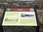
Visit Ombey, Transcontinental Railroad, Utah
Ombey, Utah is a ghost town located in the western part of Box Elder County, Utah. It was established by the Central Pacific Railroad (CPRR) on April 1869. Chinese railroad workers built a small community and facilities to support the track section. The town relied on the railroad through its entire history. In 1904 the site was abandoned when the Lucin Cutoff was fin... -
Explore Oregon Badlands Wilderness, Oregon
The Oregon Badlands Wilderness is a 29,301-acre (11,858 ha) wilderness area located east of Bend in Deschutes and Crook counties in the U.S. state of Oregon. The wilderness is managed by the Bureau of Land Management as part of the National Landscape Conservation System and was created by the Omnibus Public Land Management Act of 2009, which was signed into law by Pre... -
Visit Oregon Trail Fourmile Canyon Historic Site, Arlington, Oregon
Visible ruts from the wagons, oxen and horses of Oregon Trail travelers at the Oregon Trail Fourmile Historic Site. This segment of the Oregon Trail was part of the difficult transit of the Columbia Plateau. Interpretive panels explain the site’s deep rut scars and the emigrants’ ascent out of the canyon. From I-84, take exit 137, then drive four miles ... -
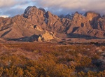
Explore Organ Mountains-Desert Peaks National Monument, New Mexico
The Organ Mountains-Desert Peaks National Monument is a United States National Monument in New Mexico, managed by the Bureau of Land Management as part of the National Landscape Conservation System. The 496,330 acre monument protects a variety of geological, paleontological and archaeological resources.President Barack Obama designated the monument on May 21, 2014.Hal... -
Explore Owens Peak Wilderness, California
The Owens Peak Wilderness is a 73,767-acre (298.52 km2) wilderness area comprising the rugged eastern face of the Sierra Nevada Mountains. Owens Peak (8,445 ft) is the high point. The land was set aside with the passage of the California Desert Protection Act of 1994 (Public Law 103-433) by the US Congress. The mountainous terrain has deep, winding, open and expansive... -
Explore Owyhee River Wilderness, Idaho
The Owyhee River Wilderness is located on the high basalt plateaus of Owyhee County in southwestern Idaho in the western United States. The wilderness area is named after and protects the upper Owyhee River, its tributaries, and the surrounding desert canyon landscape. Whitewater rafting is a popular recreational activity in this wilderness area. Managed by the Bureau... -
Explore Pahrump Valley Wilderness, California
The Pahrump Valley in the north, the Mesquite Valley in the southeast, and the California Valley in the west join forces in this desolate, seldom-visited Wilderness. Alluvial slopes in all three valleys ascend gradually southward into the northern Kingston Range, which also lies within the Wilderness. In the mountains, you'll find a rugged piece of earth with many can... -
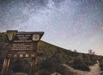
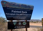
Camp At Painted Rock Petroglyph Site Campground, Arizona
The campground offers visitors 59 individual campsites and two large group sites featuring picnic tables and steel fire rings. There is no water or electric hookups at the campground, but there are two vault toilets and trash collection. The neighboring day-use site has two shaded picnic areas with tables and charcoal grills. The path to the Painted Rock Petroglyph Ca... -
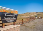
Explore Panoche Hills, California
Hilltops over 2,500 feet high offer scenic vistas of the lush San Joaquin Valley and spectacular Sierra Nevada Mountains. The Panoche Hills was once part of a vast inland sea. Fossils found include vertebrates such as mosasaurs, plesiosaurs, and marine turtles. -
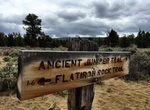
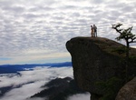
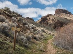
Hike Panther Ridge Trail to Hanging Rock, Oregon
The Panther Ridge Trail #1253 follows Panther Ridge from Clay Hill to Buck Point along the upper elevation of the northern wilderness border. A side trail provides access to the unique vista of Hanging Rock, which is a large rock outcrop on a sheer vertical cliff. It provides excellent views into Eden Valley and the Rogue River Canyon. Trail follows an old Native Ame... -
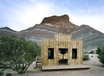
Visit Paria, Utah
Paria or Pahreah, is a ghost town on the Paria River in Grand Staircase-Escalante National Monument in central Kane County, Utah, United States. It was inhabited from 1870 to 1929, and later used as a filming location. The area was first settled in 1865 by a Mormon group led by Peter Shirts. This early settlement was namedRockhouse, for Shirts's strongly built sandsto... -
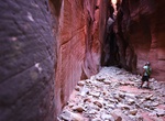
Hike Parunuweap Canyon, Utah
Parunuweap Canyon close to as spectacular as Zion Narrows. The canyon begins as a rocky gulch just south of the Mount Carmel Junction, and goes west for 16 miles, where it opens up and empties into the Virgin River. At some places, the river rushes between walls that are only 20 feet apart, and tower hundreds of feet over the riverbed. -
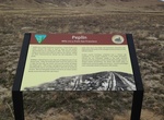
Visit Peplin, Transcontinental Railroad, Utah
Peplin, Utah is a ghost town located in the western part of Box Elder County, Utah. It was established by the Central Pacific Railroad (CPRR) on April 1869. Chinese railroad workers built a small community and facilities to support the track section. The town relied on the railroad through its entire history. In 1904 the site was abandoned when the Lucin Cutoff was fi... -
Hike Pike Creek Trail, Steens Mountains, Oregon
Pike Creek Trail is an old mining track that leads 1.4 miles up the canyon through a rugged rock narrows with wildflowers and views of the desert playa below. Continue for 1.3 miles to the end of the trail. Looks for an old cabin and an old mine on the way. Two creek crossings can be difficult to pass in early spring and after summer thunderstorms. -
Summit Pilot Rock, Cascade-Siskiyou National Monument, Oregon
Pilot Rock is a prominent volcanic plug located in the western Cascade Range near the east end of the Siskiyou Mountains, just east of the Siskiyou Summit near Ashland, Oregon. Rising thousands of feet above the Shasta and Rogue valleys, it is a landmark distinguishable from over 40 miles (64 km) away. At 25.6 million years old, it is one of the oldest formations of t...