Give us feedback!

Our philosophy is simple. We want to encourage you to dream. BIG! Then we help you plan your trip, get the most out of it while you're traveling and help you share your experience with friends.
Join Now It's FREE
Related Categories
Dreams Still To Do
Checked-Off Dreams
Dreams Still To Do
Checked-Off Dreams
Advertisement
Explore Bureau of Land Management (BLM)
-
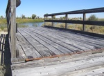
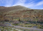
Visit Lombard Ferry, Wyoming
Lombard Ferry is one of many locations along the Green River where ferry crossings were built. During the time of the westward emigration, wagons, livestock and people crossing the river were faced with a choice to try to ford the river or pay to take the ferry. The price for the crossing depended on the depth of the water and speed of the current. The ferry here is a... -
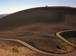
Drive Loop Road, Craters of the Moon National Monument, Idaho
The seven-mile loop road in Craters of the Moon National Monument, Idaho provides unequaled opportunities to explore the National Monument; including access to trails that take you over, under, and around various volcanic features. Trail mileages are round-trip distances. Allow half an hour for the drive itself and more time for stopping at viewpoints and for hiking t... -
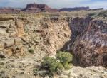
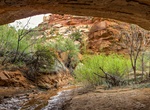
Canyoneer Lower Black Box, San Rafael Swell, Utah
The Lower Black Box is along the San Rafael River has carved a deep narrow slot canyon into the heart of the San Rafael Swell. It has 400 feet high and in places only 25 feet wide. PThe hike takes 7-7 hours and usually means in the water for 4 hours, so plan on being wet and cold. Many people use an inflated inner tube to float through the deep-water sections of the ... -
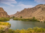
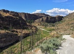
Explore Lower Owyhee Canyon, Oregon
A majestic and overlooked area on the primary road to Lake Owyhee State Park, the Lower Owyhee Canyon area includes the Owyhee River Below the Dam Area of Critical Environmental Concern -- 11,239 acres of public land in and around the Owyhee River canyon just north of the Owyhee Dam. This area features the controlled-flowing Owyhee River with its narrow canyon bottom... -
Camp at Macks Canyon Campground, Oregon
Macks Canyon site, which boasts riverside campsites, amazing canyon views and the occasional freight train encounter. Macks Canyon Campground was the location of a winter village occupied by Indian people more than 2,000 years ago. The occupants built semi-subterranean pit houses. The hunted bighorn sheep and deer, and gathered fresh water mussels for food. The site w... -
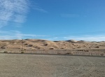
Camp at Mammoth Wash, Imperial Sand Dunes, California
Mammoth Wash camping area is a BLM-managed, dispersed camping area located on the north end of the Imperial Sand Dunes complex. This open area allows OHV use and offers a more isolated experience. Permits may be purchased off-site at vendors or on-site at the ranger stations -
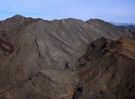
Explore Marble Mountains Fossil Beds, California
Marble Mountain Fossil Bed contains one of the classic Cambrian trilobite fossil sites within the Western United States. The Marble Mountain Fossil Beds lie in a beautiful shale formation that is 60-feet thick and over 550 million years old. Trilobites were small marine crustaceans that resemble modern-day horseshoe crabs. Trilobite refers to the three long spinal sec... -
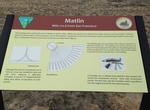
Visit Matlin, Transcontinental Railroad, Utah
Matlin, Utah is a ghost town located in the western part of Box Elder County, Utah. It was established by the Central Pacific Railroad (CPRR) on April 5, 1869. Chinese railroad workers built a small community and facilities to support the track section. The town relied on the railroad through its entire history. In 1904 the site was abandoned when the Lucin Cutoff was... -
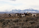
Explore McCullough Peaks HMA, Wyoming
The McCullough Peaks Wild Horse Herd Management Area (HMA) is located 12 to 27 miles east of Cody (70 miles east of Yellowstone National Park) and encompasses 109,814 acres of land, including the McCullough Peaks Wilderness Study Area. The climate is typical of a cold desert with annual precipitation averaging five to nine inches. Stock reservoirs and intermittent str... -
Explore McLoughlin Canyon, Tonasket, Washington
For millennia, people have named places in a variety of ways. Some places are named for their resemblance to objects, like Table Rock; some for their function, like Miner’s Flat or Fishermen’s Bend; and some for their features, like Split Rock. Some are also named for people, or events that have taken place there. Both of these are the case with McLoughlin... -
Explore Medicine Lodge WSA, Wyoming
The Medicine Lodge WSA consists of spectacular canyon walls towering 1,000 feet above Medicine Lodge Creek. Elevations range between 5,100 and 8,500 feet. Medicine Lodge Canyon rates extremely high in scenic value, which is based on the rich color combinations, vertical cliffs, spires, formations, and the variation in form, pattern, texture and type of vegetation foun... -
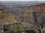
Hike Mee Canyon (Arch Tower & Mee Canyon Alcove), Colorado
Mee Canyon is a remote scenic area within the Black Ridge Canyons Wilderness which in turn forms the core of the Bureau of Land Management administered McInnis Canyons National Conservation Area in west central Colorado. Limited access and primitive facilities limit visitation and help preserve the wilderness in its natural state. Arch Tower is a 375-foot-tall (114 m)... -
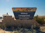
Camp at Midway Campground, Imperial Sand Dunes, California
Midway Campground is located off of Grey's Well Road and offers visitors areas to camp. Vaulted toilets and dumpsters are available on site. Access to Midway Campground is best made by taking Gray's Well Road Exit off of Interstate 8. Follow Gray's Well Road past the Buttercup Ranger Station and continue west. -
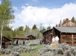
Visit Miner's Delight, Wyoming
Hamilton City, or Miner's Delight as it was commonly known, was a town in Fremont County, Wyoming, United States, on the southeastern tip of the Wind River Range, that prospered during the mining boom in the American West in the second half of the 19th century. It was a "sister city" of Atlantic City and South Pass City. Today a few buildings still stand as a reminder... -
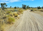
Off-road Mojave Road (Mohave Trail/Old Government Road), California
The Mojave Road, also known as Old Government Road formerly the Mohave Trail is a historic route and present day dirt road across what is now the Mojave National Preserve in the Mojave Desert in the United States. This rough road stretched 147 miles (237 km) from Beale's Crossing (the river crossing site on the west bank of the Colorado River, opposite old Fort Mohave...