Give us feedback!

Our philosophy is simple. We want to encourage you to dream. BIG! Then we help you plan your trip, get the most out of it while you're traveling and help you share your experience with friends.
Join Now It's FREE
Related Categories
Dreams Still To Do
Checked-Off Dreams
Dreams Still To Do
Checked-Off Dreams
Advertisement
Explore Bureau of Land Management (BLM)
-
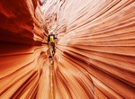
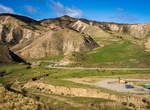
Explore Grand Staircase-Escalante National Monument, Utah
The Grand Staircase-Escalante National Monument contains 1.9 million acres (7,571 km2) of land in southern Utah, the United States. There are three main regions: the Grand Staircase, the Kaiparowits Plateau, and the Canyons of the Escalante. The Monument stretches from the towns of Big Water, Glendale and Kanab, Utah on the southwest, to the towns of Escalante and Bou... -
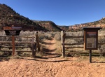
Hike Greenhalgh Trail, Kanab, Utah
The Greenhalgh (pronounced “Green-off”) Trail is a three- to four-mile roundtrip out-and-back hiking and equestrian trail north of Kanab, UT. The trail is named for the Greenhalgh brothers, two local characters who homesteaded the area in the 1900s. There are two primary trailheads. Hikers and equestrian users with full-sized vehicles can park on the north... -
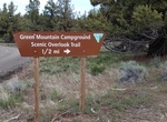
Camp at Green Mountain Campground, Oregon
Featuring panoramic views of the lava flows, cinder cones, and desert landscape of the Fort Rock and Christmas Valley area of central Oregon, the Green Mountain Campground offers a remote camping experience perfect for photography, solitude and stargazing. The site offers 6 first-come, first-served primitive campsites between the peaks of Green Mountain and East Gree... -
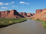
Explore Green River, Utah
The Green River, located in the western United States, is the chief tributary of the Colorado River. The watershed of the river, known as the Green River Basin, covers parts of the U.S. states of Wyoming, Utah, and Colorado. The Green River is 730 miles (1,170 km) long, beginning in the Wind River Mountains of Wyoming and flowing through Wyoming and Utah for most of i... -
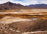
Visit Grimshaw Lake Important Bird Area, Tecopa, California
Often called the "Crown Jewel of the Mojave Desert," the Amargosa is the only free-flowing river in the Death Valley region of the Mojave, providing a rare and lush riparian area in the desert. The narrow Amargosa Canyon is known for its dense greenery and the shallow Amargosa River, complete with "hanging gardens" and a small waterfall. The river flows year-round dro... -
Explore Griswold Hills Recreation Area, California
Within the steep and rugged Griswold Canyon, BLM land straddles both sides of the road. There is a day use facility, which features a parking area, a shade structure, picnic benches, a vault toilet, and a kiosk providing an interpretive panel, a map, and information about the area. -
Explore Gulkana Wild and Scenic River, Alaska
The Gulkana River watershed drains approximately 2,140 square miles of Southcentral Alaska. The river begins in the Alaska Range near Summit Lake and flows south into the Copper River, which eventually empties into the Gulf of Alaska between Cordova and Katalla. Several hundred lakes and ponds are scattered throughout the spruce-dominated forest of the Gulkana River w... -
Explore Gunnison Gorge National Conservation Area, Colorado
The Gunnison Gorge National Conservation Area is a 62,844-acre (254.32 km2) National Conservation Area located in west-central Colorado near Montrose. It is managed by the Bureau of Land Management (BLM) as part of the National Landscape Conservation System. 57,725 acres (233.60 km2) were designated in the Black Canyon of the Gunnison National Park and Gunnison Gorge ... -
Camp at Hamburger Rock Campground, Utah
The Hamburger Rock Campground is located north off the Needles Highway (accessed from Highway 211), approximately three miles southeast of Canyonlands National Park and 17 miles northwest of Newspaper Rock. The campground provides 10 campsites, mostly situated at the base of the Hamburger Rock geologic feature. This is the closest site to Canyonlands National Park, an... -
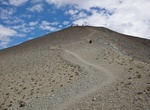
Hike Handies Peak, San Juan Mountains, Colorado
Handies Peak is a high and prominent mountain summit of the San Juan Mountains range in the Rocky Mountains of North America. The 14,058-foot (4284.8 m) fourteener is located in the Bureau of Land Management Handies Peak Wilderness Study Area, 13.4 miles (21.5 km) southwest by west (bearing 232°) of the Town of Lake City in Hinsdale County, Colorado, United States... -
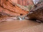
Hike to Harricane Wash to Coyote Gulch, Utah
Coyote Gulch is one of the most loved hiking destinations in southern Utah. The Hurricane Wash Trailhead is loacted at mile 33 on Hole-in-the-Rock Trail. Begin hiking East into the dry Hurricane Wash for 5.7 miles to reach Coyote Gulch. The hiker registration box is located 0.2 mile down the wash. It's 13 miles one-way from the Hurricane Wash Trailhead to Escalante R... -
Off-road Hart Point Road, Utah
Harts Point Road (San Juan County Road 137) is accessed on Route 211 in the Indian Creek Recreation Area. The road is 15 miles itself, with trails leading off all along the way. Harts Point Road puts you at a higher elevation than Indian Creek. No cell service, no GPS, no wifi; make sure to have paper maps and written out directions. -
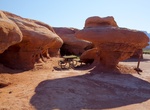
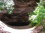
Hike Hidden Lake Recreation Site, Utah
Hidden Lake is a small water-filled cave peeking out from under a red sandstone cliff. It can be a fun side-trip for visitors to Best Friends Animal Sanctuary or Peek-A-Boo Canyon. The recreation site includes a small picnic area 200 feet from the cave. Do not drink from or swim in the cave; the water is stagnant and may contain debris. Please pick up after your group... -
Visit Historic Route 66 California Gateway Site, Needles, California
Bureau of Land Management has picnic area and informational at the Historic Route 66 California Gateway Site, south of Needles. The site is located near the intersection of Five Mile Road and Interstate 40 in San Bernardino County. -
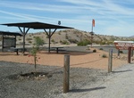
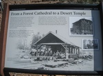
Visit Historic Sawmill Site, Nixon Spring & Mt Trumbull Trailhead, Arizona
There are no ruins remaining here but this is where the lumber mill processed the giant ponderosas for the frame of the St. George LDS Temple. The sounds of the steam-powered lumber mill would have rumbled in this valley, punctuated by the metallic screams of a blade cutting logs to size. The boards were loaded onto wagons and ox teams pulled the wagons over 80 miles ...