Give us feedback!

Our philosophy is simple. We want to encourage you to dream. BIG! Then we help you plan your trip, get the most out of it while you're traveling and help you share your experience with friends.
Join Now It's FREE
Related Categories
Dreams Still To Do
Checked-Off Dreams
Dreams Still To Do
Checked-Off Dreams
Advertisement
Explore Bureau of Land Management (BLM)
-
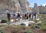
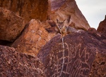
Off-road to Castle Gardens Petroglyph Site, Wyoming
The Castle Gardens Petroglyph Site is located in central Wyoming approximately 45 miles east of Riverton. The name of the area comes from the outcropping of sandstone which the wind has eroded into fanciful shapes resembling the turrets and towers of castle. This unusual formation has been luring visitors for thousands of years, and many of them left their mark in the... -
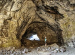
Hike Caves Trail (Dewdrop Cave, Indian Tunnel, Beauty Cave & Boy Scout Cave), Craters of the Moon National Monument, Idaho
The Caves Trail (1.6 mi/2.6 km) covers the Cave Area is the final stop on Loop Drive and, as the name indicates, has a collection of lava tube caves. On a summer day, the cool, dark lava tubes along the Caves Trail offer a radical change from the brilliant light and blistering heat on the surface. Formed from the Blue Dragon Flow, the caves are a half-mile (800 m) fro... -
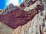
Off-road to Cedar Canyon Petroglyphs, Wyoming
The Cedar Canyon Petroglyphs are dated back more than 200 years, with some of the petroglyphs unique to this location, including several panels that include depictions of plants and markings referred to as calendars. Cedar Canyon is south of Fifteenmile Knoll and southwest of Pine Canyon. Cedar Canyon has an elevation of 6,542 feet. The panels are a 250 ft uphill wal... -
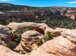
Explore Cedar Mesa Area, Bears Ears National Monument, Utah
NOTE: If you’re planning on backpacking or day hiking in this area, keep in mind that you may need a permit or pass to do so. Cedar Mesa is a plateau in San Juan County in the southeastern portion of the U.S. state of Utah. It extends from Elk Ridge in the north, Comb Wash to the east, the gorge of the San Juan River to the south, and Grand Gulch to the west, an... -
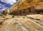
Hike to Cedar Mesa Citadel Ruins (The Citadel), Utah
Citadel Ruin is located at the end of a point overlooking Road Canyon in Cedar Mesa, Utah. The hike is about 4 mile roudtrip. There is a nice area to camp at the trailhead (which is at the end of a dirt road overlooking the canyon). Use is allocated by the total number of overnight visitors at each trailhead per day. Large groups (eight to twelve people), groups wit... -
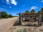
Explore Cedar Mountain Recreation Area, Castle Dale, Utah
The Cedar Mountain Recreation Area consists of 880 acres of public lands administered by the Bureau of Land Management (BLM). This horseshoe-shaped, juniper-rimmed mountain stands 1,000 feet above valley and provides vantage points with panoramic views of the Yampa Valley. There is a parking area, pit toilet and picnic tables with fire grates. Motorized vehicle use i... -
See Cedar Tree Arch (Rainbow Arch), Rattlesnake Canyon, Colorado
Cedar Tree Arch (also known as Rainbow Arch) has a span of 76 feet and an opening height of 43 feet. It's located in Rattlesnake Canyon in the Black Ridge Canyons Wilderness (BRCW) in western Colorado. -
Explore Ceja Pelon Mesa, New Mexico
Ceja Pelon Mesa is one of the lesser known badlands of northwest New Mexico that offers sandstone formations, extensive colorful badlands and one of the largest petrified wood concentration anywhere in New Mexico. It's 13 miles along a dirt road from Route 197 on BLM land close to the easternmost edge of the Navajo Indian Reservation. -
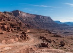
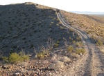
Off-road or Mountain Bike Chicken Corners Safari Trail & Kane Springs Road, Moab, Utah
Chicken Corners Safari Trail is a very popular ATV, UTV and dirt bike area near Moab, Utah. Descend the dramatic west side of Hurrah Pass to the Colorado River. Explore natural caves at Catacomb Rock. From Chicken Corners, look across river to see dramatic Thelma & Louise Point. Camp in designated sites only in Kane Creek Canyon. -
See Chidago Canyon Petroglyphs, California
The Volcanic Tableland offers exceptional bouldering opportunities, because of its unique geologic features formed by the cataclysmic volcanic eruption of the Long Valley Caldera 750,000 y.a. which left a highly dissected landscape of Bishop Tuff. Through time, this once barren tableau has evolved to support a unique and fragile environment that takes a keen eye and t... -
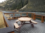
Camp at Chimney Rock Campground, Oregon
The Chimney Rock Campground has 15 campsites on a first come, first serve bases and it is open year-round. There are accessible toilets and water. -
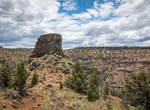
Hike Chimney Rock Trail, Oregon
The 2.6 mile round trip hike to Chimney Rock involves a moderate climb up a side drainage, some switchbacks, and ends with expansive views of the Crooked River Canyon and Cascades in the distance. The trailhead is located on the east side of State Highway 27, opposite Chimney Rock Campground. The Lower Crooked Wild and Scenic River is a 12-mile drive south from Prinev... -
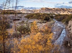
Hike China Ranch Date Farm Trail, California
China Ranch Date Farm Trail is in the Amargosa ACEC (River Area of Critical Environmental Conceern). The Amargosa ACEC is a desert oasis that covers approximately 21,552 acres of BLM-managed public lands along 3 sections of the Amargosa River in southeastern Inyo and northeastern San Bernardino Counties. -
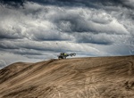
Off-road Christmas Valley Sand Dunes, Oregon
The Christmas Valley Sand Dunes are a natural sand dune complex covering 11,000 acres (45 km2) of public lands east of Christmas Valley in Lake County, Oregon, United States, about 100 miles (160 km) southeast of Bend. The area is accessible via the Christmas Valley National Back Country Byway. The dunes are up to 60 feet (18 m) high. It is the largest inland shifting... -
Explore Chuckwalla Mountains, California
The Chuckwalla Mountains are a mountain range in the transition zone between the Colorado Desert—Sonoran Desert and the Mojave Desert, climatically and vegetationally, in Riverside County of southern California. The range spans about 40 miles (64 km), running in a generally northwest-southeast direction. It is bordered to the north by Interstate 10 and the town ...