Give us feedback!

Our philosophy is simple. We want to encourage you to dream. BIG! Then we help you plan your trip, get the most out of it while you're traveling and help you share your experience with friends.
Join Now It's FREE
Related Categories
Dreams Still To Do
Checked-Off Dreams
Dreams Still To Do
Checked-Off Dreams
Advertisement
Explore Bureau of Land Management (BLM)
-
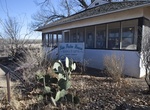
Visit San Pedro House Visitor Center, Sierra Vista, Arizona
The San Pedro House is located 9 miles east of Sierra Vista on Arizona Route 90, is a popular trailhead for birdwatchers, hikers, and mountain bikers. The Friends of San Pedro operate a bookstore and information center. -
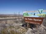
Explore San Pedro Riparian National Conservation Area, Arizona
The San Pedro Riparian National Conservation Area (San Pedro Riparian NCA) contains nearly 57,000 acres (23,000 ha) of public land in Cochise County, Arizona, between the international border with Mexico and St. David, Arizona. The riparian area, where some 40 miles (64 km) of the upper San Pedro River meanders, was designated by Congress as a Riparian National Conser... -
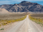
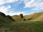
Explore San Rafael Swell, Utah
The San Rafael Swell is a large geologic feature located in south-central Utah, United States about 16 miles (26 km) west of Green River. The San Rafael Swell, measuring approximately 75 by 40 miles (121 by 64 km), consists of a giant dome-shaped anticline of sandstone, shale, and limestone that was pushed up during the Paleocene Laramide Orogeny 60–40 million y... -
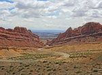
Drive through San Rafael Swell & Spotted Wolf Canyon, Utah
Interstate 70 (I-70) is a mainline route of the Interstate Highway System in the United States connecting Utah and Maryland. In Utah between Fremont Junction and the junction of SR-24 near Green River, Interstate 70 crosses a geologic feature called the San Rafael Swell. The construction of the freeway through the swell is listed as one of the engineering marvels of t... -
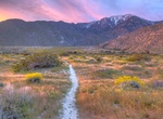
Explore Santa Rosa and San Jacinto Mountains National Monument, California
The Santa Rosa and San Jacinto Mountains National Monument is a National Monument in Southern California. It includes portions of the Santa Rosa and San Jacinto Mountain ranges, the northernmost ones of the Peninsular Ranges system. The national monument covers portions of Riverside County, west of the Coachella Valley, approximately 100 miles (160 km) southeast of do... -
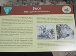
Visit Seco, Transcontinental Railroad, Utah
Seco, Utah is a ghost town located in the western part of Box Elder County, Utah. It was established by the Central Pacific Railroad (CPRR) on April 1869. Chinese railroad workers built a small community and facilities to support the track section. The town relied on the railroad through its entire history. In 1904 the site was abandoned when the Lucin Cutoff was fini... -
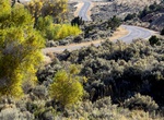
Drive Seminoe-Alcova Backcountry Byway, Wyoming
The 64-mile Seminoe-Alcova Back Country Byway lies in south central Wyoming. As you travel, you'll pass pronghorn-grazed prairie, stark desert, and you'll climb the rugged Seminoe Mountains. Attractions along the byway include Alcova and Pathfinder reservoirs, Seminoe Reservoir, the Seminoe and Pedro mountains, and Seminoe State Park. Although the road is in a remote ... -
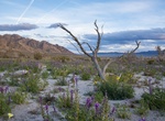
Explore Sheephole Valley Wilderness, California
The Sheep Hole Mountains are a mountain range in the Mojave Desert, to the north of Joshua Tree National Park, in San Bernardino County, California. The mountains were once Chemehuevi hunting grounds. Sheephole Valley Wilderness is the largest wilderness in Mojave Trails National Monument and the closest to the city of 29 Palms. It’s a great place to explore the... -
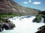
See Sherars Falls, Oregon
Sherars Falls i located along the Deschutes Wild and Scenic River at River Mile 44. It has a vertical drop of 15 feet. Native Americans still fish for salmon using traditional platforms and nets. -
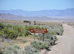
Camp at Simpson Springs Campground, Utah
Campground situated at an important station site along the Pony Express National Historic Trail's route across the Utah west desert. During 1860 and 1861, horse riders risked their lives delivering the mail along this route. Today, you can stop at stations and interpretive sites along the Backcountry Byway where riders rested before they raced on to their 1,800-mile m... -
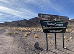
Explore Sloan Canyon National Conservation Area, Henderson, Nevada
In November 2002, Congress designated the Sloan Canyon National Conservation Area (NCA) to preserve and protect a portion of southern Nevada’s Mojave Desert for future generations. The 48,438 acre national conservation area forms the southern mountainous skyline of Las Vegas and the City of Henderson. The Sloan Canyon Petroglyph Site is one of the most signifi... -
Explore Sloan Canyon NCA (North McCullough Wilderness), Nevada
Sloan Canyon National Conservation Area’s 48,438 acres provide peace and solitude for those who visit the unique scenic and geologic features and extraordinary cultural resources. Surroundings can vary from lowland dry lake beds to volcanic rock peaks reaching more than 5,000 feet. The centerpiece of the area is the Sloan Canyon Petroglyph Site, one of the most... -
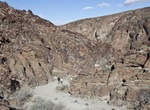
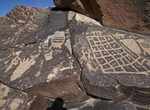
Hike to Sloan Canyon Petroglyph Site, Sloan Canyon, Nevada
The centerpiece of Sloan Canyon NCA is the Sloan Canyon Petroglyph Site, one of the most significant cultural resources in Southern Nevada. Archeologists believe the more than 300 rock art panels with 1,700 individual design elements were created by native cultures from the Archaic to historic era. The BLM currently maintains a policy of not publicizing the exact loc... -
Explore Slocum Creek WSA, Oregon
The Slocum Creek Wilderness Study Area (WSA) (OR-3-75) is located east of Owyhee Reservoir in Malheur County, approximately 47 miles south of Vale. U.S. Highway 95 is approximately 30 miles to the southeast. The WSA includes 7,600 acres of BLM land. It is pear-shaped, approximately 5.5 miles long and 3 miles wide. It is bounded by the high standard, gravel Leslie Gulc... -
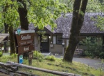
Explore Smullin Visitor Center, Oregon
Information center for Rogue Wild and Scenic River in Oregon.