Give us feedback!

Our philosophy is simple. We want to encourage you to dream. BIG! Then we help you plan your trip, get the most out of it while you're traveling and help you share your experience with friends.
Join Now It's FREE
Related Categories
Dreams Still To Do
Checked-Off Dreams
Dreams Still To Do
Checked-Off Dreams
Advertisement
Explore Bureau of Land Management (BLM)
-
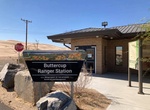
Visit Buttercup Ranger Station, Imperial Sand Dunes, California
Buttercup Ranger Station is located off of Grey's Well Road near Interstate 8. This station offers visitors a location to purchase their dunes permit, gather information and seek medical aid. This station is open Friday through Sunday from mid-October to mid-April during the high visitation period. Access the Buttercup Ranger Station by traveling on Interstate 8. Exi... -
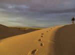
Off-road Buttercup Sand Dunes, California
Buttercup Sand Dunes is right off I-8 and is part of the greater Imperial Sand Dunes Recreation Area. Buttercup is also home to the last-remaining section of wooden plank road. -
Off-road to Cadiz Dunes Wilderness, California
The Cadiz Dunes Wilderness now contains a total of 19,935 acres and is managed by the Bureau of Land Management. All of the Wilderness is in the state of California. In 1994 the Cadiz Dunes Wilderness became part of the now over 109 million acre National Wilderness Preservation System. These small dunes, part of the Mojave Trails National Monument, were formed by nort... -
Off-road Cadiz Road, Mojave Trails National Monument, California
The 50 mile Cadiz Road goes through the southern section of Mojave Trails National Monument. It's a generally wide, flat, graded track suitable for regular vehicles unless wet, linking Chambless on Route 66 with Hwy 62. Along the way it passes close to the Cadiz Duneswilderness area - a small group of orange-pink sand dunes, entirely unvegetated, explorable from two t... -
Explore Cady Mountains, California
The Cady Mountains are a mountain range in the Mojave Desert and within Mojave Trails National Monument, in San Bernardino County, California. The mountains are one of the best ranges in the Mojave to see bighorn sheep. They are located between Interstate 15 and Interstate 40, just east of Newberry Springs. The range lies to the west of the Bristol Mountains, and reac... -
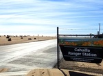
Visit Cahuilla Ranger Station, California
Cahuilla Ranger Station is located off of Gecko Road. This station offers visitors a location to purchase their dunes permit, gather information and seek medical aid. This station is open Friday through Sunday from mid-October to mid-April during the high visitation period. -
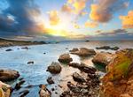
Explore California Coastal National Monument, California
The California Coastal National Monument is located along the entire coastline of the U.S. state of California. This monument ensures the protection of all islets, reefs and rock outcroppings along the coast of California within 12 nautical miles (22 km) of shore along the entire 1,100-mile (1,800 km) long California coastline. Conservative estimates are for at least ... -
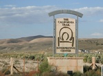
Visit California Trail Interpretive Center, Elko, Nevada
Between 1841 and 1869, up to 250,000 people sold their belongings, packed wagons, and set out for California. The California Trail Interpretive Center offers dioramas and interactive exhibits that immerse the visitor in the trail experience of those who endured the 2,000 mile trek. Curious about the California Trail? While many are familiar with the Oregon Trail, the ... -
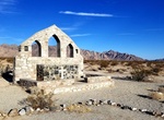
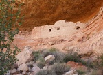
Off-road to Camp Iron Mountain Chapel, California
Camp Iron Mountain was a World War II installation, one of a number established during the 1942- 44 period. It was located in the Desert Training Center/California Arizona Maneuver Area, just north of Camp Granite, almost halfway between Indio and the Colorado River, south of Needles. Camp Iron Mountain was primarily used by the 3d Armored Division. Camp Iron Mountai... -
Explore Canyons of the Ancients National Monument, Colorado
Canyons of the Ancients National Monument is located in the southwestern region of the U.S. state of Colorado, and is managed by the U.S. Bureau of Land Management, an agency within the U.S. Department of the Interior. Auto routes through the Monument are few; most roads are unpaved and rough. Most of the archaeological sites in this "outdoor museum" are not apparent ... -
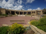
Visit Canyons Of The Ancients Visitor Center & Museum, Dolores, Colorado
Canyons of the Ancients Visitor Center and Museum (aka Anasazi Heritage Center) is Southwest Colorado's premier archaeological museum, operated by the Bureau of Land Management since 1988. All museum facilities are wheelchair-accessible. Canyons of the Ancients Visitor Center and Museum is a museum focusing on Ancestral Puebloan, Native American, and historic culture... -
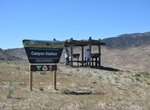
Visit Canyon Station, Pony Express Trail, Utah
This Pony Express station is the third one in this area due to the other two stations being burned by the indians. The original station is located up the canyon about three miles to the west. -
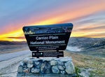
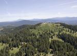
Explore Carrizo Plain National Monument & San Andreas Fault, California
The Carrizo Plain is one of the easiest places to see surface fractures of the San Andreas Fault; they are clearly visible along the eastern side of the plain, at the foot of the Temblor Range. They are best seen in early morning and evening light, when shadows enhance the topography. In addition to its spring wildflower displays, Carrizo Plain is famous for Painted R... -
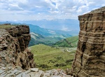
Explore Carter Mountain, Wyoming
Carter Mountain (12,324 ft (3,760 m)) is in Shoshone National Forest in the U.S. state of Wyoming. Carter Mountain slopes gently up from the Bighorn Basin to the east but has steep cliffs on its western face. The region is well known for large herds of bighorn sheep, pronghorn and elk. This area is a popular hunting and UTV/AVT riding area with great scenic views all ... -
Explore Cascade–Siskiyou National Monument, Oregon
The Cascade–Siskiyou National Monument is a federally protected area that encompasses approximately 52,940 acres at the junction of the Cascade Range and the Siskiyou Mountains in southwestern Oregon, United States. It was established by President Bill Clinton on June 9, 2000. Native Americans are known from archaeological excavations to have inhabited the regio...