Give us feedback!

Our philosophy is simple. We want to encourage you to dream. BIG! Then we help you plan your trip, get the most out of it while you're traveling and help you share your experience with friends.
Join Now It's FREE
Related Categories
Dreams Still To Do
Checked-Off Dreams
Dreams Still To Do
Checked-Off Dreams
Advertisement
Explore Bureau of Land Management (BLM)
-
Visit Crystal Wash, Crystal Springs, Nevada
Crystal Wash is an interpreted rock art site on BLM land near Ash Springs, Nevada. One panel in particular (#6 on the local guide available at the check-in register), is well worth visiting. -
Explore Dark Canyon Wilderness, Utah
Dark Canyon Wilderness is a designated Wilderness Area in the heart of southeast Utah's canyon country, part of the Bears Ears National Monument. The wilderness is named for its high steep walls that narrow in the lower section so that they block the light in the morning and late afternoon. The roughly horseshoe-shaped wilderness is made up of the upper part of 40-mil... -
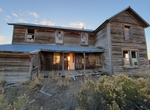
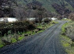
Visit David L. Shirk Ranch, Oregon
The David L. Shirk Ranch is a historic ranch located in the Guano Valley of eastern Lake County, Oregon, United States. The ranch was originally homesteaded in 1881. It was purchased by David L. Shirk in 1883. He operated the ranch until 1914. The property was acquired by the United States Government in 1942. The ranch is now administered by the Bureau of Land Managem... -
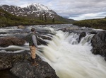
Explore Delta Wild and Scenic River, Alaska
The Delta River watershed extends from the Upper Tangle Lakes downstream to Black Rapids; the Tangle River flows through and connects the lakes (150,000 acres, 160 miles of streams, and 21 lakes) before finding its way to the Delta River. The Delta then flows north to join the Tanana River and, eventually, the Yukon River. The topography in the vicinity of the lower D... -
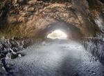
Explore Derrick Cave, Fort Rock, Oregon
A lava tube 30 feet high, 50 feet wide, and 1/4 mile long, Derrick Cave was named for H.E. Derrick, a pioneer rancher in the Devils Garden area. Derrick Cave developed just south of the main vent for the Devils Garden Flows and was the route of most of the lava which spread south from the vent. In the 1960s, Derrick Cave was designated a nuclear fallout shelter with s... -
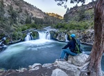
Drive Deschutes River Backcountry Byway, Oregon
From the Oregon-Washington border past the whitewater rafting community of Maupin, the BLM manages dozens of camping sites, boat ramps and picnic areas along the Deschutes. Also along the river is the 34-mile-long Deschutes River Backcountry Byway. The 9-mile-long paved section ends at Sherars Falls, where Native Americans still fish for salmon using traditional plat... -
Explore Deschutes Wild and Scenic River, Oregon
The Deschutes River is located in central Oregon. It provides much of the drainage on the eastern side of the Cascade Range on its way to its confluence with the Columbia River. The Deschutes was an important resource for thousands of years for Native Americans and in the 19th century for pioneers on the Oregon Trail. The river runs through a deep rimrock-lined canyon... -
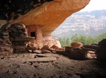
Explore Desolation Canyon Wilderness Area, Utah
The Desolation Canyon Wilderness Area is a true crown jewel in Utah and all public lands managed by the BLM. It was one of the areas that was expanded due to the John D. Dingell, Jr. Conservation, Management, and Recreation Act, signed into law on March 12, 2019 by President Trump. The 84-mile segment of the Green River winds through pristine views of the towering De... -
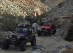
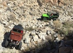
Off-road Devils Canyon (Jacumba Mountains), San Diego County, California
Devils Canyon is a steep canyon in the Jacumba Mountains in Imperial and San Diego County, California. Its mouth is located at an elevation of 1,109 feet (338 m) in Imperial County. Its head is at an elevation of 3,560 feet (1,090 m) in the Jacumba Mountains in San Diego County. From 1862 Devils Canyon was the route of a wagon road between San Diego and Yuma, Arizona... -
Off-road & Hike Devils Canyon & Meyer Creek Loop, San Diego County, California
Devils Canyon runs from Mountain Springs, off Interstate 8, to Ocotillo just East of the San Diego/Imperial County line. Descend Devils Canyon eastward to the desert floor, then loop around to follow Meyer Creek back up. This parallels and crisscrosses the eastbound lanes of Interstate 8. This offers a chance to explore sections of the old 1915 concrete highway. From... -
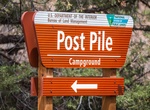
Camp at Devil's Post Pile Campground, Oregon
Devil's Post Pile Campground is located on the shores of the lower Crooked river near Prineville. It offers 7 single sites for tents and RV's with the majority located on the river. -
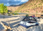
Camp at Dewey Bridge Campground, Utah
Campsites are located along the banks of the Colorado River looking across to the scenic sandstone "Entrada Bluffs" area. Individual sites are available on a first-come, first-serve basis. Two group sites are available for reservation through Recreation.gov. The campground accommodates tents and small RVs and offers quiet and shady sites.There is river access for smal... -
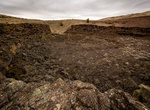
Explore Diamond Craters, Burns, Oregon
The Diamond Craters is a monogenetic volcanic field about 40 miles (64 km) southeast of Burns, Oregon. The field consists of a 27-square-mile (70 km2) area of basaltic lava flows, cinder cones, and maars. The reexamination of radiocarbon dates from older studies and interpretation of paleomagnetic data and new radiocarbon dates limits the eruption of volca... -
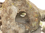
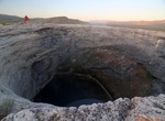
See Diana's Punchbowl (Devil's Cauldron), Nevada
Diana's Punchbowl, also called the Devil's Cauldron, is a geothermal feature located on a small fault in Nye County, Nevada. The spring is exposed through a cup-shaped depression about 49 feet (15 m) in diameter at the top of a domelike hill of travertine about 600 feet (183 m) in diameter. Warm water in the pool of the bowl is about 30 feet (9 m) below the rim, while... -
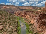
Explore Dolores River, Colorado
The lower stretch of the Dolores River offers technical rapids, stunning scenery, wildlife viewing, side-canyon hiking, and great camping. A free permit is required. Groups must read and adhere to all stipulations of the permit. Call the Moab Field Office at 435-259-2100 to secure a free permit for floating the Dolores River. Rapids on this section of the Dolores Riv...