Give us feedback!

Our philosophy is simple. We want to encourage you to dream. BIG! Then we help you plan your trip, get the most out of it while you're traveling and help you share your experience with friends.
Join Now It's FREE
Related Categories
Dreams Still To Do
Checked-Off Dreams
Dreams Still To Do
Checked-Off Dreams
Advertisement
Explore Bureau of Land Management (BLM)
-
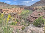
Explore Dominguez-Escalante National Conservation Area, Colorado
Known for its breathtaking scenery, the Dominguez-Escalante National Conservation Area is a fine example of the spectacular canyon country of Colorado's Uncompahgre Plateau. Red-rock canyons and sandstone bluffs hold geological and paleontological resources spanning 600 million years, as well as many cultural and historic sites. The Ute Tribes today consider these pin... -
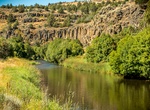
Explore Donner und Blitzen River, Oregon
From its headwaters on Steens Mountain to the Malheur National Wildlife Refuge boundary, the Donner und Blitzen Wild and Scenic River offers breathtakingly beautiful scenic glaciated canyons, unique ecosystems, and exceptional wild trout fisheries. The Donner und Blitzen River, known as the Blitzen River and its tributaries, is located approximately 70 miles south of... -
Explore Dripping Springs Natural Area, New Mexico
Overlooking Las Cruces from the east are the Organ Mountains, a haven for hikers and adventure seekers alike. The Organs, which rise to over 9,000 feet in elevation, are so named because of the steep, needle-like spires that resemble the pipes of an organ. This picturesque area of rocky peaks, narrow canyons and open woodlands shelters the Dripping Springs Natural Are... -
Explore Eagletail Mountains Wilderness, Arizona
The 100,600-acre (407 km2) Eagletail Mountains Wilderness is part of the Eagletail Mountains of central-west Arizona, about 65 mi west of Phoenix. The wilderness is of moderate size, with the Eagletail Mountains forming its northeast perimeter, and the much shorter Cemetery Ridge section, forming its southwest border. The wilderness covers nearly all of the Eagletail ... -
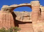
See East Rim Arch (Akiti Arch or Centennial Arch), Rattlesnake Canyon, Colorado
East Rim Arch (also known as Akiti Arch or Centennial Arch) has a span of 40 feet and an opening height of 120 feet. It's located in Rattlesnake Canyon in the Black Ridge Canyons Wilderness (BRCW) in western Colorado. -
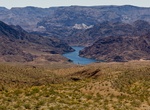
Explore Eldorado Wilderness, Nevada
Contained within this wilderness area are the striking Eldorado Mountains. They are an intricate web of peaks and side canyons with craggy cliffs extending to the waters of the Colorado River. The area is unmatched in its stark beauty. Jointly managed by the National Park Service and Bureau of Land Management, this prime bighorn sheep habitat of steep mountains contra... -
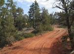
Off-road to Elephant Cove, Utah
The Elephant Cove Staging Area provides a parking and staging location for ATV/UTV enthusiasts interested in exploring the fantastic red-rock scenery and four-wheel-drive roads that make up the western side of the BLM Kanab Field Office. Amenities include a vault toilet, informational kiosk, picnic tables, fire pits, and a large, graveled parking lot. No other amenit... -
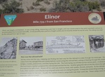
Visit Elinor, Transcontinental Railroad, Utah
Elinor, Utah is a ghost town located in the western part of Box Elder County, Utah. It was established by the Central Pacific Railroad (CPRR) on April 1869. Chinese railroad workers built a small community and facilities to support the track section. The town relied on the railroad through its entire history. In 1904 the site was abandoned when the Lucin Cutoff was fi... -
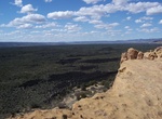
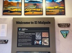
Explore El Malpais National Conservation Area, New Mexico
The El Malpais National Conservation Area (NCA) was established in 1987 to protect nationally significant geological, archaeological, ecological, cultural, scenic, scientific, and wilderness resources surrounding the Zuni-Bandera volcanic field. El Malpais translates to "the badlands" in Spanish. There are two visitor centers that serve the NCA, both off of I-40. El M... -
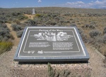
Visit El Malpais Ranger Station, Grants, New Mexico
The El Malpais Ranger Station is open Friday, Saturday, and Sunday from 8:30 am to 4:30 pm. For more information about the conservation area. A 1.5-mile graded and marked nature trail heads up the ridge behind the ranger station. Restrooms, water, and a picnic table are available. -
Visit False Parting of the Ways, Wyoming
This Interpretive pullout is at one of the locations where the Emigrant Trail crosses State Highway 28. The site was thought to be the Parting of the Ways, but was later shown to be the intersection of the Point of Rocks to South Pass Stage Route and the Emigrant Trail. This is a fee-free site and is ADA accessible. -
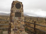
Visit Faust Pony Express Station, Utah
Faust Pony Express Station in Utah was operated by Henry J. Faust who was a native of Germany. The Faust monument can be seen about 30 miles south of Tooele on State Route 36 and five miles from Vernon. -
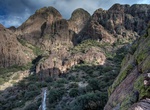
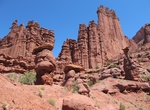
Hike Fisher Towers National Recreation Trail, Utah
This small campground accommodates tents only (no trailers or RVs) and offers some of the most expansive and striking views in the area. Individual sites are available on a first-come, first-served basis. The views of Colorado River basin, including Castle Rock, Castle Valley and the high mesas to the north, are stunning. This area features a National Scenic Trail wh... -
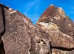
See Fish Slough Petroglyphs, California
The Volcanic Tableland offers exceptional bouldering opportunities, because of its unique geologic features formed by the cataclysmic volcanic eruption of the Long Valley Caldera 750,000 years ago, which left a highly dissected landscape of Bishop Tuff. Through time, this once barren tableau has evolved to support a unique and fragile environment that takes a keen eye... -
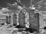
Visit Fort Craig National Historic Site, New Mexico
The 160 acre Fort Craig Historic Site, managed by the BLM in the ruggedly-beautiful Socorro County in western New Mexico. Commissioned in 1854, Fort Craig was one of the largest and most important frontier forts in the West. The Fort was situated on El Camino Real de Tierra Adentro (the Royal Road to the Interior Lands) — the 1,200-mile Spanish colonial trail f...