Give us feedback!

Our philosophy is simple. We want to encourage you to dream. BIG! Then we help you plan your trip, get the most out of it while you're traveling and help you share your experience with friends.
Join Now It's FREE
Related Categories
Dreams Still To Do
Checked-Off Dreams
Dreams Still To Do
Checked-Off Dreams
Advertisement
Explore Bureau of Land Management (BLM)
-
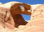
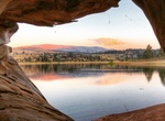
See Hole-in-the-Bridge Arch (Bridge Arch), Rattlesnake Canyon, Colorado
Bridge Arch (also known as Hole-in-the-Bridge Arch) has a span of 40 feet and an opening height of 30 feet. It's located in Rattlesnake Canyon in the Black Ridge Canyons Wilderness (BRCW) in western Colorado. -
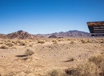
Explore Hollow Hills Wilderness, California
Hollow Hills is characterized by a large and gentle bajada that slopes east to west toward Silver Lake, a dry lake that lies just outside the Wilderness' southwest boundary. The bajada is interspersed with washes. Low hills in the east crawl toward the Turquoise Mountains, a gentle range with rounded peaks and smooth-sided ridges. Elevations range from about 300 feet ... -
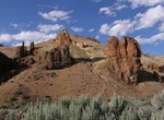
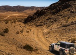
Explore Honeycombs WSA, Oregon
The Honeycombs Wilderness Study Area (WSA) is located in Malheur County, Oregon, east of the Owyhee Reservoir and approximately 31 miles south of Vale. Oregon State Highway 201 is approximately 15 miles northeast of this WSA. The WSA includes 39,000 acres of Bureau of Land Management (BLM) land. The WSA has an oblong configuration and is bounded on the south, east, an... -
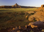
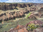
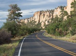
Explore Indian Creek Area, Bears Ears National Monument, Utah
The Indian Creek area contains the northern portion of Bears Ears National Monument. Indian Creek has something to offer everybody: rock climbers come to test their skills on world-class crack climbing routes, bird watchers scan high cliffs for Golden Eagles and Peregrine Falcons, and photographers seek to capture the moment when late afternoon light illuminates canyo... -
Camp at Indian Creek Campground, California
Indian Creek Campground is nestled in the eastern foothills of the Sierra Nevada between the California towns of Woodfords and Markleeville. Elevation in the area ranges from 5,600 feet at the reservoir to 6,400 feet in the surrounding foothills. Pine trees and sagebrush dot the landscape. Summers are generally warm and dry with daytime temperatures occasionally reach... -
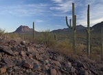
Explore Ironwood Forest National Monument, Arizona
Ironwood Forest National Monument is located in the Sonoran Desert and the U.S. state of Arizona. Created by Bill Clinton by Presidential Proclamation 7320 on June 9, 2000, the 129,022 acre monument is managed by the U.S. Bureau of Land Management, an agency within the U.S. Department of the Interior. Although the National Monument status applies only to federal lands... -
Explore Jacks Creek River, Idaho
Big Jacks Creek is located in Owyhee County, Idaho. Beginning north of Riddle, it flows north and east through the Big Jacks Creek Wilderness, ultimately flowing into the Bruneau River. Enveloped by sheer and terraced canyon walls, this perennial stream is surrounded by riparian vegetation. Redband trout are found in the creek, and bighorn sheep inhabit the canyon. Th... -
Explore Jawbone Canyon, Mojave, California
Jawbone Canyon is a geographic feature in the Mojave Desert and a Bureau of Land Management area located in Kern County, California, 20 miles (32 km) north of Mojave on CA 14 near Cantil, CA. The area is a popular destination for hikers and off road vehicle enthusiasts. Europeans first settled in the canyon around 1860—naming it Jawbone because its shape resembl... -
Off-road Jawbone Canyon OHV Area, California
The Jawbone Canyon Off-Highway Vehicle Area provides a wide variety of riding opportunities including cross country play, trail riding, and advanced technical hill climbing opportunities. Jawbone is also a great starting point to begin to explore the hundreds of miles of trail riding opportunities available in the area outside of the OHV Open Area. -
Camp at Joe Skeen Campground, Grants, New Mexico
This high desert campground is set back from the highway. Each of the 10 free campsites (no reservation system/first come, first served basis) has a covered picnic table, fire grill, and tent space. There are two vault toilets. Some of the sites have pull through parking ideal for total lengths up to 50 feet. There is a steep arroyo at the entrance and drivers should ... -
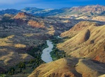
Explore John Day Wild and Scenic River, Oregon
The John Day River is the longest undammed river in Oregon. Located in eastern Oregon, the section from Service Creek to Tumwater Falls flows through a number of colorful canyons broad valleys, and breathtaking terrain. This segment offers exceptional anadromous steelhead and warm-water bass fishing; calm water boating punctuated with a few rapids; and locations of ar... -
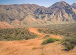
Off-road Johnson Valley OHV Area, Landers, California
Johnson Valley is a varied landscape for the off-highway vehicle driver. It is punctuated by steep red rocky mountains, rolling hills, open valley, dry lake beds and sandy washes. Elevations range from 4,600 feet at Hartwell Hills to 2,300 feet at Melville Dry Lake. Vegetation consists of creosote scrub, annual grasses, wild flowers and Joshua Trees. Johnson Valley of... -
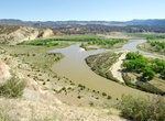
Explore John Wesley Powell National Conservation Area, Utah
John Wesley Powell National Conservation Area is located in the heart of dinosaur land. The NCA will protect and enhance significant historic, cultural, natural, scientific, scenic, recreational, archaeological, educational, and wildlife resources on 29,868 acres. The use of motorized vehicles and grazing within the NCA is permitted in accordance with the Vernal Field... -
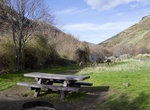
Camp at Jones Canyon Campground, Oregon
Fee campground, vehicle access, toilet, tables, garbage service. -
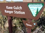
Visit Kane Gulch Ranger Station, Utah
Kane Gulch Ranger Station, located at the Grand Gulch Trailhead, should be your first stop when visiting Cedar Mesa. The station has archaeological exhibits and interpretive displays, in addition to staff that can answer your questions and give hiking recommendations. Permits are required for exploring Cedar Mesa—you can get day use permits at the trailheads or ...