Give us feedback!

Our philosophy is simple. We want to encourage you to dream. BIG! Then we help you plan your trip, get the most out of it while you're traveling and help you share your experience with friends.
Join Now It's FREE
Related Categories
Dreams Still To Do
Checked-Off Dreams
Dreams Still To Do
Checked-Off Dreams
Advertisement
Explore Bureau of Land Management (BLM)
-
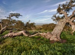
Visit Fort Ord National Monument, California
Fort Ord was a U.S. Army post on Monterey Bay in California. It was established in 1917 as a maneuver area and field artillery target range and was closed in September 1994. Fort Ord was one of the most attractive locations of any U.S. Army post, because of its proximity to the beach and California weather. The 7th Infantry Division (Light) was its main resident for m... -
Off-road Fort Sage OHV, California
The Fort Sage Off-Highway Vehicle Area is located in the high desert region of northeastern California outside the town of Doyle. The area is about 45 miles south of Susanville, California and 45 miles north of Reno, Nevada. The special Recreation Management Area consists of approximately 28,598 acres of public land that is managed for off-highway vehicle use such as ... -
Explore Fortymile Wild and Scenic River, Alaska
The Fortymile River is an extensive network of creeks and rivers in east-central Alaska, 392 miles of which are designated a National Wild and Scenic or Recreational River. The river's numerous forks flow into the 'mainstem' Fortymile River, which joins the Yukon River in Canada. River float trips, camping, and sightseeing from the Taylor Highway are the primary attr... -
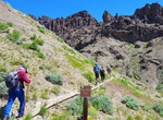
Hike Four Bear Trail, Wyoming
The Four Bear Trailhead provides access to the Four Bear Trail that is suitable for horseback riding, hiking, and limited mountain biking. Facilities at the trailhead include an information kiosk, horse trailer parking, horse hitching rails, and toilet facilities. The trail provides access to Four Bear Mountain climbing north approximately four miles to the Shoshone N... -
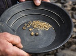
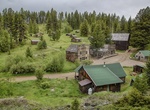
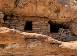
Visit Garnet, Montana
Garnet is a ghost town in Granite County, Montana, United States. Located on the dirt Garnet Range Road, it is an abandoned mining town that dates from the 1860s. In First Chance Gulch in western Montana, the town is located 11 miles up the Garnet Range Road, in beautiful mountains and forest. The town is at about 6,000 feet (1,800 m) elevation. Garnet was originally ... -
Explore Gila Box Riparian National Conservation Area, Arizona
The 23,000-acre Gila Box Riparian National Conservation Area includes four perennial waterways, the Gila and San Francisco rivers and Bonita and Eagle creeks. This region is a very special riparian ecosystem abounding with plant and animal diversity. A canyon section, known as the Gila Box, is composed of patchy mesquite woodlands, mature cottonwoods, and sandy beache... -
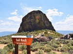
Off-road to Glamis Flag Pole, Imperial Sand Dunes, California
The Glamis Flag Pole is placed on a large metal box. The box is one of 4 or 5 that were supposedly dropped in the dunes and used for target practice for the military. It has become the place to be for Veteran’s Day in the dunes. -
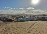
Camp at Glamis Flats Campground, Imperial Sand Dunes, California
Glamis Flats Campground is one of the most popular and busiest camping areas in the Imperial Sand Dunes. The campground offers dispersed camping with access to trash, vault toilets, and stores where you can buy supplies. The area is known for its large sand dunes, dirt bikes, dune buggies, and OHV riding. -
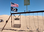
Off-road to Glamis Swingset, Imperial Sand Dunes, California
The Glamis Swingset in Glamis was just built to mremember Art Wood, who lost his battle with Cancer. If you’ve got kids, this is a definitely to put on your to-do list. The swing set isn’t far from the Flag Pole and is generally southwest of Oldsmobile Hill. -
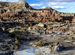
Off-road to Glass Eye Ruins, Kanab, Utah
4WD Route through Glass Eye Canyon to the ruins is a 9.6 mile out and back trail located near Kanab, Utah. -
Off-road or Mountain Bike Gold Bar Rim Safari Trail, Moab, Utah
Popular hard-core trail with great view at top from cliff rim that stands about 1200 feet above Highway 191's path in Moab Canyon. Gold Bar Rim Safari Trail connects Golden Spike Safari Trail with Gemini Bridges 4x4 Road. Often driven downhill in opposite direction described here as continuation of Golden Spike. For modified vehicles with very high ground clearance, ... -
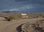
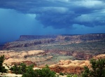
Explore Gold Butte National Monument, Nevada
Gold Butte National Monument is located northeast of Las Vegas, Nevada, around the ghost town of Gold Butte. The monument, managed by the Bureau of Land Management, protects 300,000 acres of desert landscapes featuring a wide array of natural and cultural resources, including rock art, sandstone towers, and important wildlife habitat for species like the Mojave Desert... -
Hike Gooseberry Badlands Scenic Overlook Trail, Wyoming
At a turnoff on Wyoming State Highway 431, the visitor is greeted by a panoramic view of colorful desert and endless blue sky at the Gooseberry Badlands Scenic Overlook. The colors of the soil, which mysteriously change with the seasons, accentuate the grotesque and intricately carved rock formations, inviting further exploration along a 1.5 mile interpretive trail. H... -
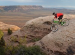
Mountain Bike Gooseberry Mesa National Recreation Trail, Utah
Gooseberry Mesa National Recreation Trail is located on Gooseberry Mesa in southern Utah's red rock country. At an elevation of 5,200 feet, views from the mesa rims are spectacular. Rising to the north are the massive sandstone sentinels of Zion National Park. Spread out below the west rim is a panorama of colorful desert mesas and water carved canyons. The Gooseberr... -
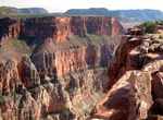
Explore Grand Canyon-Parashant National Monument, Arizona
Grand Canyon-Parashant National Monument (sometimes referred to as Parashant National Monument) is located on the northern edge of the Grand Canyon in northwest Arizona. The monument was established by Presidential Proclamation 7265 on January 11, 2000. A remote area of open, undeveloped spaces, the Grand Canyon-Parashant National Monument is an impressive and diverse...