Give us feedback!

Our philosophy is simple. We want to encourage you to dream. BIG! Then we help you plan your trip, get the most out of it while you're traveling and help you share your experience with friends.
Join Now It's FREE
Related Categories
Dreams Still To Do
Checked-Off Dreams
Dreams Still To Do
Checked-Off Dreams
Advertisement
Explore Bureau of Land Management (BLM)
-
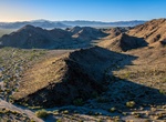
Explore Chuckwalla National Monument, California
Chuckwalla National Monument is a national monument in the Colorado Desert of Southern California. The monument's area protects more then 620,000 acres of desert woodlands and washes that provide critical habitat for millions of migrating birds, endangered desert tortoise, iconic chuckwalla lizards and other wildlife. It will stretch from south of Joshua Tree National... -
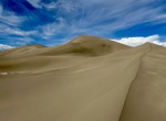
Explore Clayton Valley Dunes, Nevada
Clayton Valley Sand Dunes was designated as a SRMA in the Tonopah RMP and ROD. The site is closed to competitive recreational events. OHV use is limited to existing roads and trails. OHV use on un-vegetated sand areas is allowed. Travel SR 265 to Silver Peak continue on the road past the industrial plant, continue down the Oasis Divide Road for approximately 6.3 miles... -
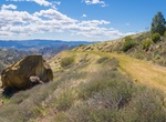
Explore Clear Creek Management Area (CCMA), California
Clear Creek Management Area (CCMA) encompasses approximately 75,000 acres, of which 63,000 acres are public lands managed by the Bureau of Land Management Central Coast Field Office. Topography is rugged with elevations ranging from 1,830 feet at Pine Canyon to 5,241 feet on San Benito Mountain. The Mediterranean climate is punctuated by cool, wet winters and hot, dry... -
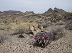
Explore Clipper Mountain Wilderness, Mojave Trails National Monument, California
The Clipper Mountain Wilderness is a wilderness area in the Clipper Mountains of the eastern Mojave Desert and within Mojave Trails National Monument, located in northeastern San Bernardino County, California. It is under the jurisdiction of the Bureau of Land Management. The 33,843-acre (13,696 ha) Clipper Mountain Wilderness is found mostly on the northern section o... -
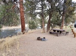
Camp at Cobble Rock Campground, Oregon
Located along the Crooked River National Back Country Byway, the 8-mile Chimney Rock segment boast diverse scenery and wildlife and provides access to year-round recreational activities. The Cobble Rock Campground has 14 first come, first serve campsites. -
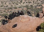
Visit Condor Viewing Site, Vermilion Cliffs National Monument, Arizona
From a low of 22 condors in 1982, over 200 California condors now live in the wild. The Peregrine Fund, in partnership with the Bureau of Land Management (BLM), has released condors from Vermilion Cliffs National Monument since 1996. A number of condors roost on top of the Vermilion Cliffs. This site offers visitors a chance to see these enormous endangered birds in t... -
Camp at Coon Hollow Campground, Colorado Desert, California
Located in the lower Colorado Desert in eastern Riverside County, the Coon Hollow campground is located adjacent to a desert riparian wash populated by palo verde, smoke tree, mesquite and ironwood trees. There is easy 4-wheel drive access to nearby rock-hounding sites: Hauser Geode Beds and Opal Hill Fire Agate Mine. The historic Bradshaw Trail National Scenic Byway ... -
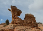
Hike Cottonwood Teepees Trail, South Coyote Buttes, Arizona
Cottonwood Teepees is located in the Coyote Buttes South area. Vivid earth-tone hues, swirling sandstone shapes and fragile rock layers are along the hike. You must have a permit to visit Coyote Buttes South. Permits are available for day use only. There is a daily limit on permits. In December, January, and February Coyote Buttes South online permits rarely sell out... -
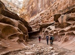
Hike Crack Canyon, San Rafael Swell, Utah
Crack Canyon is a narrow slot running through the San Rafael Reef, in the San Rafael Swell near Temple Mountain. From the signed trailhead, follow an old road as it heads down the wash. It gets progressively worse as you follow it toward Crack Canyon. As you near the reef, where the canyon deepens, the road ceases to exist, and a wooden fence marks the end of motor ve... -
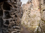
Hike Crack in the Ground, Oregon
Over time, earthquakes and volcanos have split and splintered the earth’s surface. Such shocks to the system are not uncommon over the span of six billion years. But still, they have caused many cracks and blisters in the ground. So…why doesn’t more of our earth look like the Grand Canyon, if not “Land of the Lost?” Rock rubble, along w... -
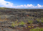
Explore Craters of the Moon National Preserve, Idaho
Craters of the Moon National Monument and Preserve is a United States National Monument in the Snake River Plain of Central Idaho. The park was created to protect a vast landscape of lava flows with scattered islands of cinder cones and sagebrush. Starting 15,000 years ago, the landscape was created by molten lava flows. While the park's landscape varies tremendously ... -
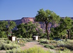
Camp at Creek Pasture Campground, Utah
Creek Pasture Campground is ideal for groups wishing to recreate in the Indian Creek area or to be close to the Canyonlands National Park Needles District and the Bears Ears National Monument Indian Creek Unit. The campground is located north off the Needles Highway (accessed from Highway 211), approximately 5 miles southeast of Canyonlands National Park and 15 miles ... -
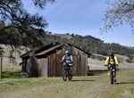
Hike or Ride Cronan Ranch Trail, California
Cronan Ranch Trailhead is located in Pilot Hill, California. The area contains 12 miles of trails for hiking, biking, horseback riding, fishing, bird watching and other passive recreation. There is a wide variety of terrain to choose from, including gently sloped to challenging hills, oak woodland and gentle riverfront trails. Each season offers a diverse experience. ... -
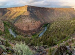
Explore Crooked Wild and Scenic River, Oregon
Lower Crooked Wild and Scenic River, which was designated a Federal Wild and Scenic River in 1988. Located along the Crooked River National Back Country Byway, the 8-mile Chimney Rock segment boast diverse scenery and wildlife and provides access to year-round recreational activities. The area provides for many types of recreation activities including: camping, fishin... -
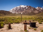
Camp at Crowley Lake Campground, California
This campground offers stunning views of Crowley Lake and the Glass Mountains to the east. To the west is the Sierra Nevada mountains and McGee Mountain and Canyon. Popular activities include lake and stream fishing, boating, windsurfing, horseback riding, hiking, and wildlife viewing. Crowley Lake and the Town of Crowley Lake are approximately 2 miles away. The Town ...