Give us feedback!

Our philosophy is simple. We want to encourage you to dream. BIG! Then we help you plan your trip, get the most out of it while you're traveling and help you share your experience with friends.
Join Now It's FREE
Related Categories
Dreams Still To Do
Checked-Off Dreams
Dreams Still To Do
Checked-Off Dreams
Advertisement
Explore Bureau of Land Management (BLM)
-
Explore Black Ridge Canyons Wilderness, Colorado & Utah
The Black Ridge Canyons Wilderness (BRCW) is located in western Colorado with a small portion extending into eastern Utah, USA, within the arid Colorado Plateau region approximately 15 miles (24 km) west of Grand Junction, Colorado. The wilderness lies on the northwest flank of the Uncompahgre Plateau. It is characterized by the high, east-west trending Black Ridge di... -
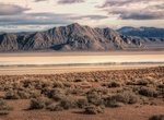
Explore Black Rock Desert, Nevada
The Black Rock Desert is a semi-arid region(in the Great Basin shrub steppe eco-region), of lava beds and playa, or alkali flats, situated in the Black Rock Desert–High Rock Canyon Emigrant Trails National Conservation Area, a silt playa 100 miles (160 km) north of Reno, Nevada that encompasses more than 300,000 acres (120,000 ha) of land and contains more than ... -
Explore Black Rock Desert – High Rock Canyon Emigrant Trails NCA, Nevada
The Black Rock Desert–High Rock Canyon Emigrant Trails National Conservation Area is the federal land in northwestern Nevada, under the Bureau of Land Management-BLM management and protection, and the ten Wilderness Areas within it. The long name has led people to often shorten it to the Black Rock–High Rock NCA, when not needing the official name. The pro... -
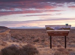
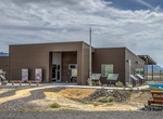
Visit Black Rock Station, Gerlach, Nevada
Black Rock Station hours vary but there are many informational displays around the facility. -
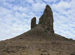
See Boar's Tusk, Wyoming
At 7100 ft elevation, Boar's Tusk is a dormant volcanic structure rising 400 ft above the valley floor. Used as a landmark for hikers, mountain bikers and railroad travelers, this distinct feature is the core of a long dormant volcanic eruption. The Lamporite material that makes up the feature dates back 2.5 million years. This is a fee-free site. A high-clearance ve... -
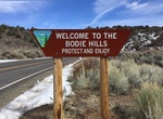
Explore Bodie Hills, California
The Bodie Hills are a low mountain range in Mono County, California, in the United States. The Bodie Hills are between Bridgeport and the Nevada border, where they become the Bodie Mountains in Mineral County, Nevada. The Sierra Nevada lies to the west. The mining district and town of Bodie, California, is located in the Bodie Hills. Summer and fall visitors to the Bo... -
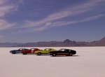
Drive on Bonneville Salt Flats, Utah
The Bonneville Salt Flats are a 30,000 acre expanse of hard, white salt crust on the western edge of the Great Salt Lake basin in Utah. “Bonneville” is also on the National Register of Historic Landmarks because of its contribution to land speed racing. The salt flats are about 12 miles long and 5 miles wide with total area coverage of just over 46 square ... -
Visit Boyd Station, Pony Express Trail, Utah
Boyd Station survives as one of the best preserved Express Stations in Utah. This preservation is probably due to the fact that Bid Boyd, station master, continued to occupy the site into the current century. Boyd Station can be found fourteen miles from Fish Springs Station, via a road around the north end of the Fish Springs Range and nine miles over the pass to th... -
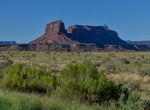
Explore Bridger Jack Mesa WSA, Utah
Bridger Jack Mesa Wilderness Study Area (WSA) is an elongated unit about 10 miles long from north to south, and a little more than 2 miles from east to west at the widest point. Located in the Canyonlands section of the Colorado Plateau Physiographic Province, Bridger Jack Mesa is bounded by spectacular orange-red cliffs. The WSA is in a natural state and has outstand... -
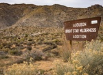
Explore Bright Star Wilderness, California
Bright Star Canyon encloses Kelso Creek and leaves Sequoia National Forest to cross the southern portion of the Bureau of Land Management's Bright Star Wilderness. In the northwestern portion, Cortez Canyon has been carved out of the Kelso Mountains. In the northeastern portion, Kelso Peak stands at 5,090 feet with drainages falling off to the north, south, and east. ... -
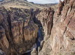
Explore Browns Canyon National Monument, Colorado
Browns Canyon National Monument is a 21,586 acres (8,736 ha) national monument in Chaffee County, Colorado that was designated as such by President Barack Obama under the Antiquities Act on February 19, 2015. The site will be centered along the Arkansas River between Buena Vista and Salida. Browns Canyon is the most popular destination for whitewater rafting in the co... -
Explore Bruneau River, Idaho
The Bruneau is formed from the Jarbidge River, which flows north from the mountains of northern Nevada through the beautiful basalt and rhyolite canyons of the Owyhee Uplands. There, it joins the West Fork of the Bruneau, then the East and West Forks join to form the mainstem. 40 miles of the Bruneau River are designated wild, and a 0.6-mile stretch at the Indian Hot ... -
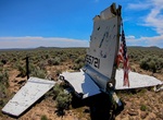
Find Burma Rim Plane Crash Sites, Oregon
NOTE: The map does not show the exact locations of these sites. Burma Rim in southern Oregon is a veritable air crash museum. Spanning nearly 30 years, this site has witnessed two major military airplane accidents. The first, a World War II airplane, dropped out of the sky to rapidly descend two miles before hitting the ground. And then in 1973, a Vietnam-era aircra... -
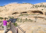
Hike to Butler Wash Ruins, Utah
Butler Wash Ruin is a cliff dwelling that was built and occupied by the Ancestral Puebloans, sometimes known as Anasazi, in about 1200 AD. Parts of the site has been stabilized and reconstructed, but most of it remains as it was found in the 1800s. There are habitation, storage and ceremonial structures, including four kivas. This ruin is located in a side canyon of B... -
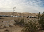
Camp at Buttercup Campground, Imperial Sand Dunes, California
Buttercup Campground is one of several campgrounds located on the sand dunes just off of Interstate 8 in the Imperial Sand Dunes Recreation Area. The campground is surrounded by hundreds of miles of sand dunes. A ranger station is located at the entrance to Buttercup Campground.