Give us feedback!

Our philosophy is simple. We want to encourage you to dream. BIG! Then we help you plan your trip, get the most out of it while you're traveling and help you share your experience with friends.
Join Now It's FREE
Related Categories
Dreams Still To Do
Checked-Off Dreams
Dreams Still To Do
Checked-Off Dreams
Advertisement
Explore Bureau of Land Management (BLM)
-
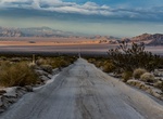
Explore Mojave Trails National Monument, California
Mojave Trails National Monument protects 941,000 acres (3,810 km2; 1,470 sq mi) of federal land between Joshua Tree National Park and the Mojave National Preserve along historic Route 66 in San Bernardino County. The purposes of the Monument are to preserve the nationally significant biological, cultural, recreational, geological, educational, historic, scenic, and sc... -
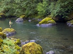
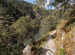
Explore Molalla River, Oregon
The Molalla River Recreation Area provides riparian habitat for species unique to the lower west slope of the Cascade Mountains. The area is home to many terrestrial and aquatic species, and provides habitat for a number of threatened fish and bird species. Riparian habitats adjacent to rivers and streams offer particularly high quality habitat for numerous species an... -
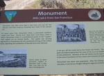
Visit Monument, Transcontinental Railroad, Utah
Monument, Utah is a ghost town located in the western part of Box Elder County, Utah. It was established by the Central Pacific Railroad (CPRR) on April 1869. Chinese railroad workers built a small community and facilities to support the track section. The town relied on the railroad through its entire history. In 1904 the site was abandoned when the Lucin Cutoff was ... -
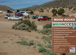
Off-road Moon Rocks OHV Area, Reno, Nevada
The Moon Rocks OHV Area is on the west side of Winnemucca Ranch Road. The recreation area features open OHV riding and multiple camping and staging areas. Due to its high-usage, open access is only possible because the area is maintained, respected, and well-kept by local OHV enthusiasts. Camping: Dispersed camping is allowed unless marked as prohibited (due to flash... -
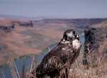
Birding Morley Nelson Snake River Birds of Prey National Conservation Area, Idaho
The Morley Nelson Snake River Birds of Prey National Conservation Area has one of the densest populations of nesting raptors. The National Conservation Area (NCA) is located 35 miles (56 km) south of Boise, Idaho along 81 miles (130 km) of the Snake River, and is managed by the Bureau of Land Management. The NCA covers 484,873 acres (1,962.21 km2). In descending order... -
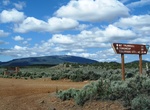
Off-road Mount Trumbull Scenic Loop Drive, Arizona
Start this loop at the Mt Trumbull Schoolhouse at Mohave County Road 5 (CR5 - Southern Section). To get there from Interstate 15, take Exit 2 east onto the Southern Parkway (Hwy 7) toward the airport. Take Exit 3 (River Road) and turn south. Set your vehicle trip odometer to 0 where the pavement ends at the state line. BLM Road 1069: You have now crossed into Ariz... -
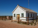
Visit Mt Trumbull Schoolhouse, Arizona
This is a historic schoolhouse that has been restored and is open to the public. The old schoolhouse holds fond memories for those who received some or all of their education there. It functioned as a school, church, dance hall, and a town meeting place. People came from miles around to attend dances and listen to music played by local musicians, which were their main... -
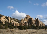
Explore Muggins Mountain Wilderness, Arizona
The Muggins Mountain Wilderness is a 7,711-acre (31.21 km2) wilderness area in the U.S. state of Arizona. It is located approximately 38 miles (61 km) east of Yuma, Arizona in the Muggins Mountains and adjacent to the agriculturalDome Valleyand Gila River. The wilderness area is made up of the highest peak in the southern section of Muggins Mountains, Klothos Temple a... -
Hike Mule Creek Trail, Oregon
The Mule Creek Trail #1159, located on the Bureau of Land Management portion of the wilderness, provides a steep route on an out mining trail between the river and Panther Ridge. In general cross-country travel is not advised due to steep slopes and heavy vegetation. The Forest Service administers the entire wilderness, including the Bureau of Land Management portion,... -
Hike Narrows Rim Trail, El Malpais National Conservation Area, New Mexico
Within the El Malpais National Conservation Area lies the Narrows. It is named for the 3-mile narrow corridor that developed when lava flowed close to the base of a 500-foot sandstone mesa. Most of the lava observed is from McCarty’s crater, and at approximately 1500 years old, it is the youngest flow in the area. The trailhead and parking area for the Narrows ... -
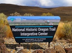
Visit National Historic Oregon Trail Interpretive Center, Baker City, Oregon
The National Historic Oregon Trail Interpretive Center is a 23,000-square-foot (2,100 m2) interpretive center about the Oregon Trail located 6 miles (9.7 km) northeast of Baker City, Oregon on Oregon Route 86 atop Flagstaff Hill. It is operated by the Bureau of Land Management in partnership with Trail Tenders and the Oregon Trail Preservation Trust, and offers living... -
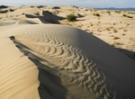
Hike or Sandboard North Algodones Dunes Wilderness, California
South of Mammoth Wash is the North Algodones Dunes Wilderness. Established in 1994, this area is closed to all mechanized traffic, so access is by foot or on horseback only. Here you will find endless miles of quiet solitude to hike and sandboard. The Algodones Sand Dunes System covers 200 square miles, making it one of the largest dune complexes in North America. Ot... -
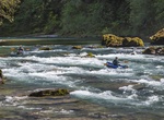
Raft or Kayak North Umpqua Wild and Scenic River, Oregon
This is a fun afternoon raft down the North Umpqua River with easy Class II and Class III rapids. You'll float by spires of volcanic rock on both sides, under several bridges and along a very twisty river with a lot of bends. There is even a fun place to stop and try out a rope swing into the river. The North Umpqua, a tributary of the Umpqua River that drains a sceni... -
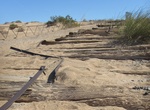
See Old Plank Road (Algodones Dunes), California
The Old Plank Road is a plank road in Imperial County, California, that was built in 1915 as an east–west route over the Algodones Dunes. It effectively connected the extreme lower section of Southern California to Arizona and provided the last link in a commercial route between San Diego and Yuma. Following Los Angeles' winning the right to be the western termi... -
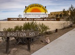
See Old Woman Meteorite at Desert Discovery Center, Barstow, California
The Desert Discovery Center houses the “Old Woman Meteorite”, the second largest meteorite found in the United States which weighed 6,070 pounds when discovered in 1975. It is 38" long, 30" wide and 34" high. It's mostly composed of iron, contains about 6% nickel and has trace amounts of cobalt, phosphorus, chromium and sulphur. The meteorite was d...