Give us feedback!


 See all

Our philosophy is simple. We want to encourage you to dream. BIG! Then we help you plan your trip, get the most out of it while you're traveling and help you share your experience with friends.
Join Now It's FREE
Dream Packages
Duration: 6 hours
Price: $162.00
Price: $162.00
Duration: 10 hours
Price: $270.00
Price: $270.00
Duration: 3 days
Price: $559.53
Price: $559.53
Duration: 4 days
Price: $772.57
Price: $772.57
Dreams Still To Do
Checked-Off Dreams
Dreams Still To Do
Checked-Off Dreams
Advertisement
Explore Driving Experiences
-
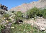
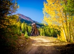
Offroad Wyman Creek Road, White Mountain, California
This road follows Wyman Creek, an old mining and pole line road. There are many stream crossings on this route, 4WD and High Clearance vehicles recommended. On the East end of Wyman Canyon is White Mountain City, in the 1860’s this was a silver processing town, only some stone walls and smelter stacks remain. The trailhead is at 10,500 ft with views west to the ... -
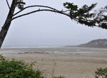
Drive Yachats Ocean Road State Natural Site, Oregon
The Yachats Ocean Road State Natural Site is a state park in southern Lincoln County, Oregon, in the town of Yachats. It is administered by the Oregon Parks and Recreation Department. It is located on the Pacific Ocean coast, adjacent to the Oregon Coast Highway and the mouth of the Yachats River. The park is open for day use only, and offers scenic driving on a 1-mil... -
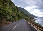
Drive Yakushima Coastal Road, Yakushima, Japan
The Coastal Road through Yakushima National Park is a great place to see wildlife along the road. -
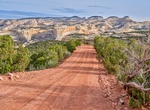
Drive Yampa Bench Road, Dinosaur National Monument, Colorado
The 18-mile Yampa Bench Road connects the Echo Park Road with the monument's southeast boundary. From there, several Moffat County dirt roads lead to US Highway 40. The Yampa Bench Road runs along a large "bench" or flat area above the Yampa River. Several viewpoints, trails and historic sites provide access to the area's dramatic scenery and history. Wildlife such as... -
Off-road or Hike to Yankee Girl Mine, Guston, Colorado
Guston was one of the many towns of the Red Mountain Mining District, Guston, Colorado. The mining camp began as a scattering of buildings around several mines, including the Guston, Robinson, Genessee, Vanderbilt, and the famous Yankee Girl. Yankee Girl Mine was the star of its time producing silver, and the fact that it was worked into the 1940's is probably why you... -
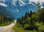
Drive Yellowhead Highway, Canada
The Yellowhead Highway is a major east-west highway connecting the four western Canadian provinces of British Columbia, Alberta, Saskatchewan, and Manitoba. Although part of the Trans-Canada Highway and the larger National Highway System, the highway should not be confused with the more southerly, originally-designated Trans-Canada Highway. The highway was officially ... -
Drive Yellowhead Pass, Canada
The Yellowhead Pass is a mountain pass across the Continental Divide of the Americas in the Canadian Rockies. It is located on the provincial boundary between the Canadian provinces of Alberta and British Columbia, and lies within Jasper National Park and Mount Robson Provincial Park. Due to its modest elevation of 1,131 m (3,711 ft) and its gradual approaches, the pa... -
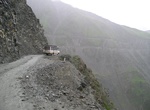
Cross Zing Zing Bar Leh–Manali Highway River Crossing, India
Zing Zing Bar is a potential dangerous river crossing on the Leh–Manali Highway. It has a small refreshment shop for riders and tourists. It has an altitude of 14010 ft above sea level. -
Drive Zion – Mount Carmel Highway, Zion National Park, Utah
The Zion – Mount Carmel Highway is a means to link Zion National Park with Grand Canyon National Park and other attractions in northern Arizona. The road runs from the entrance to Zion eastward to Mount Carmel Junction with US 89 as a portion of Utah State Route 9. The road became part of a loop tour of Zion, Bryce Canyon, Cedar Breaks and the North Rim of Grand... -
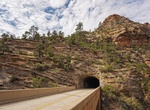
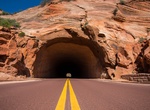
Drive through Zion - Mount Carmel Tunnel, Zion National Park, Utah
Zion - Mt. Carmel Tunnel is 1.1 mi long and is located just west of the eastern entrance to Zion National Park. The tunnel's restricted dimensions require that vehicles over 11.33 feet (3.45 m) in height or 7.83 feet (2.39 m) in width give advance notice so that two-way traffic can be shut down in the tunnel, allowing oversize vehicles to proceed down the center of th... -
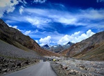
Drive Zoji La (Zojila Pass), India
Zoji La (sometimes Zojila Pass) is a high mountain pass in the Himalayas (3,528 m (11,575 ft)). It is in the Indian Union territory of Ladakh, Kargil district, Kashmir. Located in the Dras subdivision, the pass connects the Kashmir Valley to its west with the Dras and Suru valleys to its northeast and the Indus valley further east. National Highway #1 between Srinagar... -
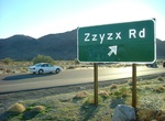
Drive Zzyzx Road to Soda Springs, Mojave National Preserve, California
Zzyzx Road is located 6 miles southwest of Baker, California on I-15. It leads 5 miles south into Mojave National Preserve along the western shore of Soda Lake (dry). Historically known as Soda Springs and later renamed Zzyzx (pronounced Zye-Zix), this oasis is home to the California State University Desert Studies Center. The buildings and pond were developed in the ...
Price: $1457.59