Give us feedback!


 See all

Our philosophy is simple. We want to encourage you to dream. BIG! Then we help you plan your trip, get the most out of it while you're traveling and help you share your experience with friends.
Join Now It's FREE
Dream Packages
Duration: 3 days
Price: $604.38
Price: $604.38
Duration: 3 days
Price: $559.53
Price: $559.53
Duration: 12 hours
Price: $154.81
Price: $154.81
Duration: 4 days
Price: $772.57
Price: $772.57
Dreams Still To Do
Checked-Off Dreams
Dreams Still To Do
Checked-Off Dreams
Advertisement
Explore Driving Experiences
-
Drive Wildlife Loop Road, South Dakota
Wildlife Loop Road (Csp Rd 1) twists and turns 18 miles on its way through the prairie and ponderosa pine-studded hills that harbor many of the park's wildlife species. On most days, guests will come face to face with the number one inhabitant of the park, 1,350 free roaming buffalo. White-tailed deer, mule deer, and elk are most visible early in the morning and late ... -
Visit Wild Rivers Back Country Byway, New Mexico
The Wild Rivers Back Country Byway is a designated one of the New Mexico Scenic Byways and operated between an area two miles north of Questa and Cerro. The 13 mile byway—NM 378—has panoramic views that include many mountain peaks like Blanca Peak. It also provides access to park facilities, like the Wild Rivers visitor center and parking lots to campgroun... -
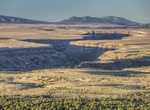
Drive Wildrose Canyon Road, Death Valley National Park, California
Wildrose Canyon Road is a mostly paved road with 2 mile section of graded gravel. RVs, trailers, and buses over 25 ft. not allowed due to a narrow, winding road. Sedans should use caution on gravel. Access to park from Panamint Valley Road. Subject to closure and flooding after heavy rains. -
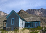
Off-road to Williams Ranch, Guadalupe Mountains National Park, Texas
To access Williams Ranch, check out a gate key at the Headquarters Visitor Center (Pine Springs). Only 4X4, high ground clearance vehicles are allowed along this rough, one-lane, dirt road. From Pine Springs drive west on highway 62/180 for 8.3 miles to a brown metal gate off the north side of the highway. The gate has a National Park Service arrowhead logo and an AT&... -
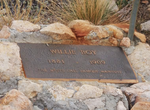
Off-road to Willie Boy Memorial Site, Landers, California
The Wests Last Famous Manhunt. Paiute Native American outlaw Willie Boy, who escapes with his lover, Lola, after killing her father in self defense. According to tribal custom Willie can then claim Lola as his wife. According to the law, Deputy Sheriff Cooper is required to charge him with murder. Willie Boy and Lola are hunted for several days by a posse led by Coope... -
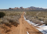
Off-road or Mountain Bike Willow Flats Road, Arches National Park, Utah
Offroad or mountain bike Willow Flats Road (BLM 378) in Arches National Park connects Hwy 191 with Willow springs Road and then Arches Scenic Drive. The Courthouse Wash crossing is often impassable. The trail is best used from March until September. -
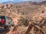
Off-road or Mountain Bike Willow Springs Trail, Herdina Park Section, Arches National Park, Utah
Herdina Park Section is located on the western side of Arches National Park in Utah that requires high-clearance 4×4. There are not too many arches in the area but it's still a great place to explore its secluded fins and canyons. Leaping Arch and Eye of the Whale Arch are must sees. The Willow Springs dirt road is less traveled than the paved roads, but they a... -
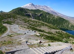
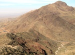
Climb Windy Ridge, Mount St. Helens, Washington State
Windy Ridge is a ridge and eponymous Forest Highway in the Mount St. Helens National Volcanic Monument. The ridge goes between Windy Pass and Independence Pass, 1 mile (1.6 km) east of Spirit Lake. Several road guides list Windy Ridge Road (NF-99) as one of the best roads in Washington State due to its good pavement, good views, and winding "sweeper" curves enjoyable ... -
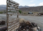
Off-road Wingate Road, California
Wingate Road started from the Ballarat ghost town and heads south along a semi-dry lake bead to Goler Canyon and beyond. Distances: Starts at Ballarat ghost town heading South Briggs Gold & Silver Mine: 8.4 miles Turnoff (West) to Goler Wash Rd/Coyote Canyon Road: 15.2 miles Turns into A Road: 17 miles -
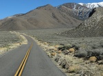
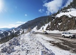
Drive Wolf Creek Pass, Colorado
Wolf Creek Pass (el. 10,857 ft.) is a high mountain pass on the Continental Divide, in the San Juan Mountains of Colorado. It is the route through which U.S. Highway 160 passes from the San Luis Valley into southwest Colorado on its way to New Mexico and Arizona. The pass is notable as inspiration of a C. W. McCall song. The pass is significantly steep on either side ... -
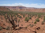
Drive Wolverine Loop Road, Staircase-Escalante National Monument
Wolverine Loop Road in Staircase-Escalante National Monument is a 28 mile unimproved road that offers access to some amazing canyon hiking. Vehicles should have high clearence and 4WD is preferred. The Wolverine road is the entry point to several canyons which are part of the larger Escalante River watershed. Some of the hikes include Horse Canyon, Wolverine Canyon, ... -
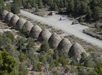
Drive Wood Canyon & Charcoal Kiln Road, Death Valley National Park, California
Woods Canyon is located off Emigrant Canyon Road in Death Valley National Park. This is a rarely visited mining camp from the early mining area of Death Valley. Because of its remote location, many of the items left behind by the miners still remain to make this a must when exploring the area. Alos off Emigrant Canyon Road is Wildrose Canyon Road. -
Drive Woodrow Bean Transmountain Drive (375), El Paso, Texas
Woodrow Bean Transmountain Drive is a 11 mile section of Loop 375 that passes through Franklin Mountains. -
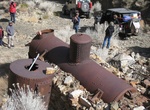
Off-road to World Beater Mine & Cabin, Pleasant Canyon Trail, Panamint Valley, California
World Beater Mine is located up Pleasant Canyon Trail from Ballarat in Panamint Valley. The tram workings are still there as well as the remains of the stamp mill structure which was burned to the ground in the 80’s by vandals. The cabin is not BLM nor adopt a cabin yet remains open for the weary traveler. -
Visit World of Wearable Art (WOW) & Classic Cars Museum, Nelson, New Zealand
The World of Wearable Art (WOW) is a museum devoted to wearable art and classic cars located in Nelson, New Zealand, opened in October 2001. The WOW Gallery shows the attending garments of the World of Wearable Art Awards Show, a two-hour performance spectacle held annually in Wellington during September. It started in Nelson in 1987 and is a popular show, attrac...


Price: $108.64