Give us feedback!


 See all

Our philosophy is simple. We want to encourage you to dream. BIG! Then we help you plan your trip, get the most out of it while you're traveling and help you share your experience with friends.
Join Now It's FREE
Dream Packages
Duration: 6 hours
Price: $162.00
Price: $162.00
Duration: 9 hours
Price: $229.00
Price: $229.00
Duration: 4 hours
Price: $135.27
Price: $135.27
Duration: 3 days
Price: $604.38
Price: $604.38
Dreams Still To Do
Checked-Off Dreams
Dreams Still To Do
Checked-Off Dreams
Advertisement
Explore Driving Experiences
-
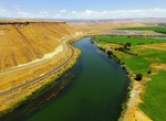
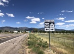
Drive U.S. Route 30 along Snake River, Idaho
US 30 along the Snake River offers many gorges and rocky terrain along the river also make it prime for a number of stunning waterfalls, many of which you’ll see along this route. the waterfalls include: Cauldron Linn Falls Shoshone Falls Perrine-Coulee Falls Auger Falls Pillar Falls Niagara Springs Falls Box Canyon Falls Lemmon Falls Falls at Malad ... -
Drive U.S. Route 50
U.S. Route 50 or U.S. Highway 50 (US 50) is a major east–west route of the U.S. Highway system, stretching 3,073 miles (4,946 km) from Interstate 80 (I-80) in West Sacramento, California, to Maryland Route 528 (MD 528) in Ocean City, Maryland, on the Atlantic Ocean. Until 1972, when it was replaced by Interstate Highways west of the Sacramento area, it extended ... -
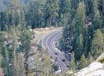
Drive U.S. Route 50 in California
In the U.S. state of California, U.S. Route 50 (US 50) runs east from I-80 in West Sacramento to the Nevada state line in South Lake Tahoe. Portions within Sacramento are known as the Capital City Freeway and El Dorado Freeway. The western half of the highway in California, from I-80 through Sacramento and Placerville to Exit 60 in Pollock Pines is a four-or-more-lane... -
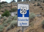
Drive U.S. Route 50 in Nevada (The Loneliest Road in America), Nevada
U.S. Route 50 (US 50) is a transcontinental highway in the United States, stretching from West Sacramento, California, in the west to Ocean City, Maryland, on the east coast. The Nevada portion crosses the center of the state and was named "The Loneliest Road in America" byLifemagazine in July 1986. The name was intended as a pejorative, but Nevada officials seized it... -
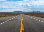
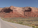
Drive U.S. Route 50 in Utah
U.S. Route 50 (US-50) in Utah crosses the center of the state. The highway serves no major population centers in Utah, with the largest city along its path being Delta. Most of the route passes through desolate, remote areas. Through the eastern half of the state the route is concurrent with Interstate 70 (I-70). US-50 both enters and exits Utah concurrent with US-6, ... -
Drive U.S. Route 60 (Apache Junction to Salt River Canyon), Arizona
U.S. Route 60 (US 60) is an east–west United States Highway within Arizona. The highway continues towards the southeast passing through Gold Canyon to an interchange with SR 79 at Florence Junction. US 60 curves towards the east at this junction as it heads to Superior and an interchange with SR 177. Beyond Superior: From Superior the highway begins to head towa... -
Drive U.S. Route 89A, Arizona & Utah
U.S. Route 89A is a 91.74-mile (147.64 km) north–south auxiliary U.S. highway (though its actual direction of travel is more east–west) in southwestern Kane County, Utah and northeastern Coconino County, Arizona in the southwestern United States. The highway is an old routing of U.S. Route 89 from Bitter Springs, Arizona to Kanab, Utah. The state of Arizon... -
Drive U.S. Route 95 in Arizona
U.S. Route 95 (US 95) is a major U.S. Highway in the American state of Arizona. Starting at the Mexican border in San Luis, US 95 acts as the main highway north through Gadsden, Somerton and Yuma before arriving in Quartzsite. Between Quartzsite and the California border on the Colorado River in Ehrenberg, US 95 runs entirely concurrent with I-10. Part of US 95 betwee... -
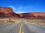
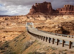
Drive Utah Scenic Byway 279, Utah
State Route 279 is a state highway in the U.S. state of Utah. The highway was constructed in 1962–1963 to service the Cane Creek potash mine and processing plant southwest of Moab. The highway was named one of the most beautiful highways opened to traffic in 1963. The entire length of SR-279 has been designated the Potash – Lower Colorado River Scenic Bywa... -
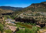
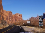
Camp along Utah State Route 128
State Route 128 (SR-128) is a state highway in the U.S. state of Utah. The entire length of the highway has been designated the Upper Colorado River Scenic Byway, as part of the Utah Scenic Byways program. This road also forms part of the Dinosaur Diamond Prehistoric Highway, a National Scenic Byway. Residents of Moab frequently refer to SR-128 as "the river road", af... -
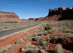
Drive Utah State Route 211 (Canyonlands Needles District), Utah
State Route 211 is a state route in Utah that is an access road for Newspaper Rock State Historic Monument and the Needles district of Canyonlands National Park. The entire length of the highway has been designated theIndian Creek Corridor Scenic Byway. The highway begins near Church Rock, a notable rock formation along U.S. Route 191 between Moab and Monticello.... -
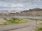
Drive Utah State Route 24 (SR-24), Utah
Utah State Route 24 (SR-24) is a state highway in south central Utah which runs south from Salina through Sevier County then east through Wayne County and north east through Emery County. At a total of 163.294 miles (262.796 km), it is the longest contiguous state route in Utah. A portion of the highway has been designated theCapitol Reef Scenic Bywayas part of the Ut... -
Drive Utah State Route 261, Utah
Utah State Route 261 is a state highway located entirely within south-central San Juan County, Utah. It runs 34 miles (55 km) north, from the junction of U.S. Route 163 (3 miles (5 km) north of Mexican Hat), to the junction with State Route 95, just east of Natural Bridges National Monument. The highway is part of the Utah section of the Trail of the Ancients, a Natio... -
Drive Utah State Route 95, Utah
State Route 95 or Bicentennial Highway is a state highway located in the southeast of the U.S. state of Utah. The highway is an access road for tourism in the Lake Powell and Cedar Mesa areas, notably bisecting Bears Ears National Monument and providing the only access to Natural Bridges National Monument. The highway does not serve any cities, but the small town of H... -
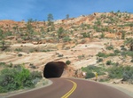
Drive Utah State Route 9 (Zion Park Scenic Byway), Utah
State Route 9 (SR-9) is a state highway in southern Utah, serving Zion National Park. It starts at the western terminus at exit 16 on I-15, passing through Zion National Park, and ending at the eastern junction with US-89. The entire length of the highway has been designated the Zion Park Scenic Byway. There is a fee to travel through Zion National Park, but the Zion-...
Price: $289.36