Give us feedback!


 See all

Our philosophy is simple. We want to encourage you to dream. BIG! Then we help you plan your trip, get the most out of it while you're traveling and help you share your experience with friends.
Join Now It's FREE
Dream Packages
Duration: 2 days
Price: $335.27
Price: $335.27
Duration: 12 hours
Price: $103.26
Price: $103.26
Duration: 6 hours
Price: $499.00
Price: $499.00
Duration: 10 hours
Price: $180.27
Price: $180.27
Dreams Still To Do
Checked-Off Dreams
Dreams Still To Do
Checked-Off Dreams
Advertisement
Explore Driving Experiences
-
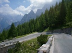
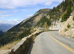
Drive to Vršič Pass, Slovenia
The Vršič Pass, with an elevation of 1,611 metres (5,285 ft), is a high mountain pass across the Julian Alps in northwestern Slovenia. It is the highest pass in Slovenia, as well as the highest in the Eastern Julian Alps. It connects Upper Carniola with the Trenta Valley in the Slovene Littoral. The road across the pass, now known as Russian Road (Ruska cesta),... -
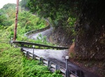
Drive Waipio Valley Road, Big Island, Hawaii
NOTE: The County of Hawaii issued an Emergency Rule announcing the closure of Waipio Valley Road to visitors indefinitely as a precautionary safety measure and to further assess and mitigate the road’s conditions, effective today, Friday, February 25, 2022. To limit vehicular traffic, the road remains open to Waipio Valley residents, farmers, property owners and... -
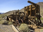
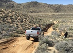
Off-road Warm Springs Road & Butte Valley Road, Death Valley, California
Warm Springs Rd requires High-clearance first ten miles to Warm Springs Talc mine and camp, then 4WD to Butte Valley due to deep ruts and rocky areas. Although mined for talc as recently as the early 1980s, Warm Springs Canyon is returning to nature. Goler Canyon Road continues west from Warm Springs Rd into Panamint Valley. Barker Ranch, hideout of the infamous Manso... -
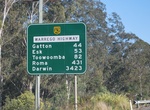
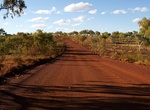
Drive Warrego Highway, Queensland, Australia
The Warrego Highway is located in southern Queensland, Australia. It connects coastal centres to the south western areas of the state, and is approximately 715 km in length. It takes its name from the Warrego River, which is the endpoint of the highway. The entire highway is part of the National Highway system linking Darwin and Brisbane: formerly National Highway 54,... -
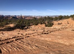
Off-road & Hike to Warrior's Walk, Utah
Warrior’s Walk in the Kanab, Utah area is a mysterious site that leaves more questions than answers try to understand who would’ve built and designed this special path lined with large boulders on either side. Some feel the historical site to be around 700-1000 years old, putting it within the same time frame as the Anasazi. -
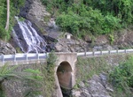
Drive Waterfall Way, New South Wales, Australia
The Waterfall Way is a road and State Highway 78 in New South Wales, Australia. It runs east-west from the Pacific Highway to the New England Highway at Armidale. The route passes through some of New South Wales' most scenic countryside and has become well known as New South Wales best and Australia's third most beautiful tourist drive. Seven national parks, three of ... -
Drive Waterton-Glacier International Peace Park Loop, Canada & USA
The Waterton-Glacier International Peace Park is the name of the union of the Waterton Lakes National Park in Canada and the Glacier National Park in the United States. Both parks are declared Biosphere Reserves by UNESCO and their union as a World Heritage Site. The stunning loop route goes through the Montana Rockies with breathtaking scenery and includes the popul... -
Off-road Watson Wash, Mojave National Preserve, California
Watson Wash Road, Mojave National Preserve, California -
Drive Weano Road, Karijini National Park, Western Australia
Weano Road in Karijini National Park end at the trailheads to Weano Gorge, Hancock Gorge, Joffre Gorge and Handrail Pool. -
Drive on Wedge Island (Western Australia)
Wedge Island is a settlement located north of Lancelin and south of Cervantes on the Western Australian coast. The name mainly refers to the mainland settlement but also refers to a 400-metre (1,300 ft) long wedge shaped island located just south of "the point". The settlement of Grey is about 15 kilometres (9.3 mi) north-west. Both are within the Shire of Dandaragan.... -
Drive West Coast, Suriname
The West Coast region of Suriname comprises the three coastal districts between Paramaribo and the western border with Guyana: Coronie, Nickerie and Saramacca. It's a region celebrated for its bird life and the Bigi Pan nature reserve can be an absolute highlight in any Suriname travels. There are a few towns and some choices as far as accommodation goes, but this is ... -
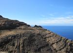
Drive West Coast of Gran Canaria Island
The drive from Puerto de Mogán to Puerto de las Nieves (Agaete) on Gran Canaria island in the Canary Islands is spectacular with its high 600 meter cliffs and narrow road. The drive has some increatable views but s not for the faint of hart. There are many turns and most of the road is very narrow. Think of the “Road to Hana” but with 1,500 foot cli... -
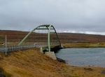
Drive Westjord Road N61 (Djúpavegur), Iceland
Route 61 (Djúpavegur) is a paved road that is 249 km (155 miles) long, running from Vestjarðavegur (Road 60) to Ísafjörður, the largest town in the Westfjords peninsula. -
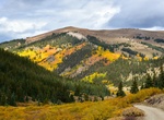
Off-road to Weston Pass, Colorado
Weston Pass OHV Road is a 34.9 mile point-to-point trail located near Leadville, Colorado. Weston Pass is a high mountain pass at an elevation of 3.633m (11,921ft). This trail is not difficult though there are a few rocks in the trail that you may want to avoid if you do not have much clearance. Four-wheel drive is not necessary. -
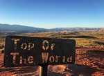
Off-road West Rim to Top of the World, Sand Hollow State Park, Utah
The route takes you south from main Sand Hollow State Park to the Top of the Rock with some fantastic views. After that head to the west side of Sand Mountain on the West Rim for Wimps looking down on the St. George area. On the way back make sure to make the right tirn about 2/3 of the way around the mountain.
Price: $1457.59