Give us feedback!


 See all

Our philosophy is simple. We want to encourage you to dream. BIG! Then we help you plan your trip, get the most out of it while you're traveling and help you share your experience with friends.
Join Now It's FREE
Dream Packages
Duration: 6 hours
Price: $499.00
Price: $499.00
Duration: 14 hours
Price: $551.14
Price: $551.14
Duration: 2 days
Price: $335.27
Price: $335.27
Duration: 3 days
Price: $559.53
Price: $559.53
Dreams Still To Do
Checked-Off Dreams
Dreams Still To Do
Checked-Off Dreams
Advertisement
Explore Driving Experiences
-
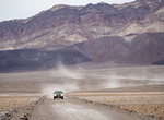
Off-road West Side Road, Death Valley National Park, California
West Side Road is a 40-mile-long graded road that parallels Badwater Road on the west side of Death Valley and is passable by two-wheel-drive vehicles. West Side Road provides access to multiple high-clearance four-wheel-drive roads, including Hanaupah Canyon, Johnson Canyon, and Warm Springs Canyon. Warm Springs Canyon Road provides a route into remote Butte Valley a... -
Drive Wetherill Mesa Road, Mesa Verde National Park, Colorado
Wetherill Mesa, known as the quieter side of Mesa Verde, is open from mid-May through the end of October. However, it has two seasonal operations, spring/fall and summer. There are no services in the spring and fall, but the trails are open for hiking and bicycling. In the summer, Wetherill Mesa is fully staffed and both cliff dwellings (Step House and Long House) are... -
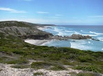
Off-road to Whalebone Point, Bremer Bay, Western Australia
Whalebone Point is a point and is east of House Beach and Peppermint Beach and northwest of Hood Point. Whalebone Beach is a scenic beach stretching between rocky headlands in a remote part of the park. When the access track is open it can reached by four-wheel-drive, otherwise on foot via the Hakea Trail. Take a 4WD east of Bremer Bay and navigate your way through th... -
Attend Whangamata Beach Hop, New Zealand
The Whangamata Beach Hop is an event held in the town of Whangamatā, on the southeast coast of the Coromandel Peninsula in the North Island of New Zealand. The first Beach Hop Whangamata Event was held in April 2001 and was established to coincide with the local Rock and Roll Club's birthday hop, which was bringing people to the town. The 2002 Beach Hop Festival put W... -
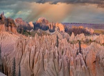
4WD & Hike to Wheeler Geologic Area, Colorado
The Wheeler Geologic Area is a highly eroded outcropping of layers of volcanic ash, in the La Garita Mountains of Mineral County, in southern Colorado in the western United States about 10 miles east north-east of Creede. The ash is the result of eruptions from the La Garita Caldera approximately 25 million years ago. The area was designated a National Monument from 1... -
Drive Wheeler Peak Scenic Drive, Great Basin National Park, Nevada
Taking a drive along the Wheeler Peak Scenic Drive is a highlight of any visit to Great Basin National Park. A true mountain road, the scenic drive hugs the mountains of the South Snake Range, slowly winding you to a point above all others, where vistas reach the horizon, and one is met with a pristine view of the rugged, harsh, yet surprisingly beautiful Great Basin ... -
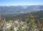
Off-road to White Bark Vista, Sierra National Forest, California
Located along a rough, one-mile long dirt road off Kaiser Pass Road, White Bark Vista features spectacular views of the Sierra Crest, Florence and Edison Lakes. While the access road is suitable only for high clearance vehicles, those traveling in passenger cars or vans may park near the beginning of the road and take a pleasant two-mile round-trip hike to the vista. -
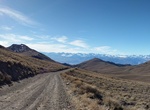
Offroad White Mountain Road, California
White Mountain Road is a very scenic mountain road located in White Mountains, Inyo County. It's starts from CA-168 road with the first 10.2 miles being paved. The remaining 18.1 miles is dirt. The road climbs up several mountain passes and runs entirely at 3.000m above the sea level. The road is very steep. The average gradient is 6.02%. -
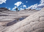
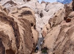
Off-road & Hike to White Pocket, Arizona
White Pocket is located on the Paria Plateau in Northern Arizona in Vermilion Cliffs National Monument. Visit this area if you can't get a permit to visit The Wave. It can only be reached by four-wheel-drive car. Once there, visitors encounter towering coral pink sand dunes. Beautiful colors of red, gold and white swirling in unique rock formations. It's about 2.5 h... -
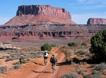
Off-road or Mountain Bike White Rim Road, Canyonlands National Park
The 100-mile White Rim Road loops in Canyonlands National Park in Utah usually take two to three days by four-wheel-drive vehicle or three to four days by mountain bike. When the weather is good the road is considered moderately difficult for high-clearance, four-wheel-drive vehicles. The steep, exposed sections of the Shafer Trail, Lathrop Canyon Road, Murphy's Hogb... -
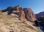
Off-Road to Whitmore Trail (BLM 1045/NPS 1245), Arizona
Whitmore Trail is accessed from a 3-hour drive west of Tuweep Overlook, St. George or Colorado River (river mile 188). This moderate 4 mile (6.5 km) roundtrip trail starts at Whitmore Overlook and goes down to the Colorado River 920 feet elevation drop from the trailhead. Watch for some rock art along the way. The road is through Grand Canyon - Parashant National Monu... -
Off-road to Whitney Pockets, Gold Butte National Monument, Nevada
Whitney Pocket is a popular undeveloped camping area out in the desert in Gold Butte National Monument, Nevada. The area has rock art left by the ancients, and The Cistern, a cement dam built by CCC (Civilian Conservation Corp) in the 1930s. From Highway 170 turn south onto the paved Gold Butte Road. Follow it for about 18 miles to Whitney Pockets. -
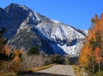
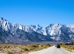
Drive Whitney Portal Road, Lone Pine, California
Whitney Portal Road starts in Lone Pine and ends at Whitney Portal. This spectacular drive takes you up the eastern Sierra Nevada mountains and is renowned for its scenic views as it ascends toward Mt Whitney. -
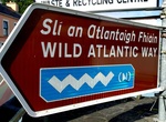
Drive Wild Atlantic Way, Ireland
The Wild Atlantic Way is a 1,500-mile route along Ireland's rugged coast from Kinsale in County Cork to the Inishowen Peninsula in County Donegal. The route includes 157 'Discovery Points' where drivers can stop and learn more about the must-sees. -
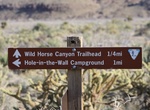
Off-road & Hike Wild Horse Mesa Road, Mojave National Preserve, California
Spectacular scenery aroound Hole-in-the-Wall includes Wild Horse Mesa, easily accessible via Wild Horse Canyon Road.

Price: $229.00