Give us feedback!


 See all

Our philosophy is simple. We want to encourage you to dream. BIG! Then we help you plan your trip, get the most out of it while you're traveling and help you share your experience with friends.
Join Now It's FREE
Dream Packages
Duration: 6 hours
Price: $162.00
Price: $162.00
Duration: 8 hours
Price: $108.64
Price: $108.64
Duration: 10 hours 30 minutes
Price: $129.01
Price: $129.01
Duration: 9 hours
Price: $229.00
Price: $229.00
Dreams Still To Do
Checked-Off Dreams
Dreams Still To Do
Checked-Off Dreams
Advertisement
Explore Driving Experiences
-
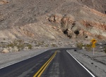
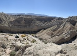
Drive Ubehebe Crater Road, Death Valley National Park, California
5 mile paved road off the Scotty's Castle Road. Subject to closure after heavy rains. -
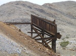
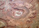
Off-road to Ubehebe Lead Mine, Death Valley National Park, California
Ubehebe Lead Mine is an interesting, but dangerous, mining area located just northwest of the Racetrack Playa in Death Valley. There are planety of holes, lots of toxic lead and other heavy metals in the soil, and therefore camping in prohibited here. -
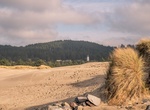
Visit Umpqua Beach #2 Day Use /OHV Staging Area, Oregon
Located south of Winchester Bay, Oregon this area is home to the tallest sand dunes in the Oregon Dunes National Recreation Area. Umpqua Beach #2 Day Use and OHV Staging Area provides parking and access for pedestrian beach access as well as off-highway vehicle (OHV) staging for open sand riding opportunities in the Umpqua dunes. A ride to the top of a tall dune offer... -
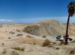
Visit Una Palma, Anza-Borrego Desert State Park, California
Una Palma is located just north of Tule Wash in Anza-Borrego Desert State Park. Use the Cut Across Trail to access or hike from walking over the ridges of the 17 and 5 Palms locations. -
Drive Upheaval Dome Road, Canyonlands National Park, Utah
Drive Upheaval Dome Road in Canyonlands National Park. -
Off-road Upper Arroyo Tapiado, Anza-Borrego Desert State Park, California
Continue to explore Arroyo Tapiado above the mud caves. At about 1.5 miles there is a right turn onto another arroyo that connects with the Arroyo Seco Del Diablo cut accross road to get to the Diablo Drop-off. It's about 4.5 miles from the mud caves to the end. Continue up the canyon to the "Dead End" fork. Turn left and continue up the creek. Narrow in spots. There ... -
Off-road Upper Coyote Canyon, Anza-Borrego Desert State Park, California
Coyote Canyon Until the mid 80’s this canyon was drivable all the way from the Terwilliger Valley to Borrego Springs City and back, now the 3.2 miles between the Upper willows and middle willows is permanently closed to motor vehicles year around. The trail is now divided in Upper Coyote Canyon and Lower Coyote Canyon and both of these sections are closed betwee... -
Drive US 191, Arizona, Utah, Wyoming & Montana
U.S. Route 191 (US 191) is a spur of U.S. Route 91 that has two branches. The southern branch runs for 1,465 miles (2,358 km) from Douglas, Arizona on the Mexican border to the southern part of Yellowstone National Park. The northern branch runs for 440 miles (710 km) from the northern part of Yellowstone National Park to Loring, Montana, at the Canada–US border... -
Drive US 64 between Morganton and Franklin, North Carolina
150 miles that is near Asheville. Among the waterfalls are Dryfalls, Bridalveil Falls, and bust your butt falls. Wolf lake. Lots of things to explore in region to north. From Asheville, Blue Ridge parkway. -
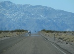
Drive US 95 (Las Vegas to Tonopah), Nevada
This 211 mile portion of US 95 from Las Vegas to Tonopah goes by ghost towns, puzzling art installations, wierd hotels, alien stuff, nuclear bomb testing sites and other stange things - in between a whole lot of nothing. -
Drive U.S. Route 101, California, Oregon & Washington
U.S. Route 101, or U.S. Highway 101, is a north–south U.S. highway that runs through the states of California, Oregon, and Washington, on the West Coast of the United States. It is also known as El Camino Real (The Royal Road) where its route along the southern and central California coast approximates the old trail which linked the Spanish missions, pueblos, an... -
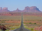
Drive U.S. Route 163, Arizona & Utah
U.S. Route 163 (also U.S. Highway 163, US 163) is a 64-mile (103 km) U.S. Highway that runs from US 160 northward to US 191 in the U.S. states of Arizona and Utah. The southernmost 44 miles (71 km) of its length is within the Navajo Nation. The highway forms part of the Trail of the Ancients, a National Scenic Byway. The highway cuts through the heart of Monument Vall... -
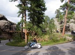
Drive U.S. Route 16A (Iron Mountain Road), South Dakota
U.S. Highway 16A (US 16A) is a 36.971-mile (59.499 km) scenic United States Numbered Highway. It is an alternate route for US 16. It splits from US 16 in the Black Hills of the southwestern part of the U.S. state of South Dakota. The highway's western terminus is an intersection with US 16, US 385, and South Dakota Highway 89 (SD 89) in Custer. The eastern terminus is... -
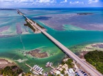
Drive U.S. Route 1 (Key West to Maine)
U.S. Route 1 is a major north–south U.S. Highway that serves the East Coast of the United States. It runs 2,369 miles (3,813 km), from Fort Kent, Maine, at the Canadian border, south to Key West, Florida. US 1 is generally paralleled by Interstate 95, though the former is significantly farther west (inland) between Jacksonville, Florida, and Petersburg, Virginia... -
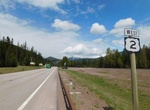
Drive U.S. Route 2 in Montana
U.S. Highway 2 (US 2) is an east–west United States Numbered Highway in the state of Montana. It extends approximately 666.645 miles (1,072.861 km) from the Idaho state line east to the North Dakota state line. US 2 is a vital northern corridor for Montana. The road has more of its mileage within Montana than in any other state. It passes through three Indian re...

Price: $772.57