Give us feedback!


 See all

Our philosophy is simple. We want to encourage you to dream. BIG! Then we help you plan your trip, get the most out of it while you're traveling and help you share your experience with friends.
Join Now It's FREE
Dream Packages
Duration: 10 hours 30 minutes
Price: $129.01
Price: $129.01
Duration: 10 hours
Price: $199.57
Price: $199.57
Duration: 14 hours
Price: $551.14
Price: $551.14
Duration: 8 hours
Price: $108.64
Price: $108.64
Dreams Still To Do
Checked-Off Dreams
Dreams Still To Do
Checked-Off Dreams
Advertisement
Explore Driving Experiences
-
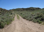
Off-road to Aurora, Nevada
Aurora is a ghost town in Mineral County in the west central part of the US state of Nevada, approximately 22 mi (35 km) southwest of the town of Hawthorne, three miles from the California border. Today the townsite is much diminished, having been damaged by vandals. After World War II many of the buildings were razed for their brick. The road to Aurora was once diffi... -
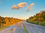
Drive Autobahn 81 (A81) from Gottmadingen to Weinsberg, Germany
195 kilometers of open highway with no speed limit through farms, vineyards, the Black Forest and medieval villages, the A81 highway just north of Stuttgart, Germany is what the Autobahn is supposed to represent: an open highway that provides pedal-to-the-metal excitement. Germany’s highway system maintains the reputation of limitless speed but in reality much ... -
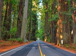
Drive Avenue of the Giants, California
The Avenue of the Giants is a scenic highway in Northern California, U.S.A., running through Humboldt Redwoods State Park. It is an old alignment of U.S. Route 101, and continues to be maintained by the state as State Route 254. The southern entrance to the Avenue is just north of Garberville, and the northern entrance is south of Fortuna. The highway is notable for t... -
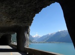
Drive Axenstrasse, Switzerland
The Axenstrasse is an 11.4-kilometre-long (7.1 mi) segment of the A4 motorway and European route E41 between the resort of Brunnen in the Canton of Schwyz, to the municipality of Flüelen in the Canton of Uri in Central Switzerland. The road is built along steep cliffs on the east side of Lake Lucerne, weaving through many rock fall galleries and tunnels along its... -
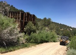
Off-road Backway 4x4 Road to Bodie Ghost Town, California
Most tourists reach Bodie Ghost Town (Bodie State Historic Park) via paved Hwy. 270. The trip described here is a more interesting backcountry route starting north of Bridgeport. On the way you’ll see great views, structures at the Chemung Mine and the historic site of Masonic. Located in Humboldt-Toiyabe National Forest. Rating: Easy. Any high clearance SUV ca... -
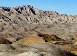
Drive or Cycle Badlands Loop Road (Hwy 240), Badlands National Park, South Dakota
The Highway 240 Badlands Loop Road, accessed from Interstate 90, is a two-lane, paved surface that takes you through the North Unit of the park. The Badlands Loop Road is open to cyclists who prefer a paved riding experience. While bicycles are allowed on the road, it is not without its hazards. The scenic road is narrow with many curves. Traffic is heavy from Memori... -
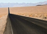
Drive Badwater Road, Death Valley National Park, California
Badwater Road is a 70 mile, paved road in Death Valley National Park which becomes State Hwy 178 the last few miles south to Hwy 127. Provides access to Golden Canyon, West Side Road, Artist’s Drive, Devil’s Golf Course, Natural Bridge, and Badwater. Road is narrower and rougher south of Badwater. Subject to flooding and closure after heavy rains. -
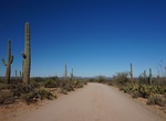
Drive or Cycle Bajada Loop Drive, Saguaro National Park, Arizona
The Bajada Loop Drive in the Tucson Mountain District (west) is a 6-mile gravel loop that includes Hohokam Road and Golden Gate Roads. Drive the loop counter clockwise since one section is one-way. Golden Gate and Hohokam Roads are dirt roads and close at sunset. Travel on Hohokam Road is not recommended for long vehicles. -
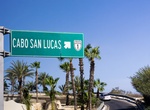
Drive Baja's Trans-peninsular Highway (Federal Highway 1), Baja California, Mexico
Federal Highway 1, known to many as 'Baja's Trans-peninsular Highway', is a toll-free (libre) part of the federal highway corridors of Mexico, and the highway follows the length of the Baja California Peninsula from Tijuana in the north to Cabo San Lucas in the south. The road connects with Via Rapida, which merges into the American Interstate 5 (I-5) at the San Ysidr... -
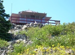
Stay at Bald Knob Lookout, Rogue River–Siskiyou National Forest, Oregon
Bald Knob was originally developed as a lookout site in 1931 when a gable-roofed "L-4" style lookout was built here. The Forest Service removed the old lookout in 1963 and replaced it with the present flat top structure that same year. Bald Knob served as an Aircraft Warning Service (AWS) observation station during 1942-44 (a small cabin was added for the observers to... -
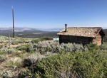
Off-road to Bald Mountain Warming Hut & Lookout, Inyo National Forest, California
Leaves Hwy. 395 from the top of Deadman Summit at Logging Camp road and goes to the Bald Mountain fire lookout station. Stay on 1S05 and follow the directions signs to Bald Mountain lookout. There are great views and the road is well-maintained. A log cabin warming hut at the top is open to the public. The warming hut, a historic cabin at the Lookout is maintained by... -
Drive up Baldwin Street in Dunedin, New Zealand
Baldwin Street in a suburban part of New Zealand's southern city of Dunedin, is considered the world's steepest residential street. It is located in the suburb of North East Valley, 3.5 kilometres (2.2 mi) northeast of Dunedin's city centre. A short straight street a little under 350 metres (1,150 ft) long, Baldwin Street runs east from the valley of the Lindsay Creek... -
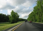
Drive Baltimore–Washington Parkway, Maryland
The Baltimore–Washington Parkway (also referred to as the B–W Parkway) is a highway in the U.S. state of Maryland, running southwest from Baltimore to Washington, D.C. The road begins at an interchange with U.S. Route 50 (US 50) and Maryland Route 201 (MD 201) near Cheverly in Prince George's County at the D.C. border, and continues northeast as a parkway ... -
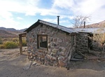
Off-road to Barker Ranch, Goler Canyon, Death Valley National Park, California
Barker Ranch is located inside Death Valley National Park in eastern California. Used as a mining and recreational property from the 1940s to the 1960s, it is infamous due to its association with Charles Manson and his "family". It was the family's de facto headquarters. NOTE: Due to a fire in May 2009, most of the main structure has been destroyed with only the concr... -
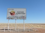
Drive Barkly Highway, Queensland & Northern Territory, Australia
The Barkly Highway is a national highway of both Queensland and the Northern Territory in Australia. It is the only sealed road between Queensland and the Northern Territory. The highway runs between Cloncurry and the junction with the Stuart Highway north of Tennant Creek, known as the "Threeways". The entire highway is part of the National Highway system: in the Nor...

Price: $154.81