Give us feedback!


 See all

Our philosophy is simple. We want to encourage you to dream. BIG! Then we help you plan your trip, get the most out of it while you're traveling and help you share your experience with friends.
Join Now It's FREE
Dream Packages
Duration: 3 hours
Price: $120.56
Price: $120.56
Duration: 4 days
Price: $772.57
Price: $772.57
Duration: 6 hours
Price: $499.00
Price: $499.00
Duration: 12 hours 30 minutes
Price: $289.36
Price: $289.36
Dreams Still To Do
Checked-Off Dreams
Dreams Still To Do
Checked-Off Dreams
Advertisement
Explore Driving Experiences
-
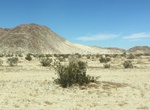
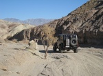
ATV Blow Sand Hill, Ocotillo Wells SVRA, California
The strong winds that blow through Ocotillo Wells Recreation Area have piled sand in this notch. The finest sand grains, being the lightest, are deposited on the top; the larger, heavier grains collect at the bottom. This is the largest concentration of sand at Ocotillo Wells SVRA and a popular, fun spot to ride. -
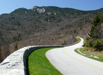
Drive Blue Ridge Parkway, North Carolina & Virginia
The Blue Ridge Parkway is a National Parkway and All-American Road in the United States, noted for its scenic beauty. It runs for 469 miles (755 km), mostly along the famous Blue Ridge, a major mountain chain that is part of the Appalachian Mountains. Its southern terminus is on the boundary between Great Smoky Mountains National Park and the Cherokee Indian Reservati... -
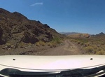
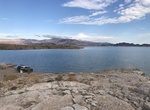
Off-road Boathouse Cove Road, Lake Mead, Nevada
Boathouse Cove Road is a 9-mile backcountry road that runs from Northshore Road south to the Virgin Basin of Lake Mead. Although the road starts out fairly flat, it does get more difficult, so a 4WD vehicle is recommended. Hiking near this road includes beautiful mountains and scenic washes as well as two backcountry campgrounds--one of which boasts a spectacular view... -
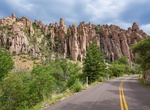
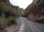
Drive Bonita Canyon Drive, Chiricahua National Monument, Arizona
Bonita Canyon Drive in Chiricahua National Monument, Arizona is a gradual climb through oak, cypress, and pine forests. This 8-mile paved drive winds to Massai Point, a perfect place for a picnic.The overlook has a 360-degree view of Rhyolite Canyon, adjacent valleys, and surrounding mountain peaks. Massai Nature Trail is a .5 mile loop trail which allows you to disc... -
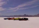
Drive on Bonneville Salt Flats, Utah
The Bonneville Salt Flats are a 30,000 acre expanse of hard, white salt crust on the western edge of the Great Salt Lake basin in Utah. “Bonneville” is also on the National Register of Historic Landmarks because of its contribution to land speed racing. The salt flats are about 12 miles long and 5 miles wide with total area coverage of just over 46 square ... -
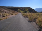
Drive Bonnie Clare Road, California & Nevada
Death Valley Route 11 also known as Bonnie Clare Road begins at the intersection of California State Highway 190 just south of the turn off for Daylight Pass Road and proceeds north then east to the Park Boundary at the Nevada state line. Bonnie Clare Road is located within Inyo County in southwestern California. The road is located within Death Valley National Park a... -
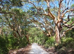
Drive Boranup Drive, Margaret River, Western Australia
In the Margaret River wine region take the unpaved Boranup Drive, which winds through a gorgeous forest of slender, towering karri trees, a native species found only in Western Australia. Stop at the lookout spot to gaze over the forest canopy to the waters of Hamelin Bay. -
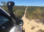
Off-road Border Track in Ngarkat Conservation Park, South Australia
Ngarkat Conservation Park is a protected area located in South Australia's south-eastern corner about 200 kilometres (120 miles) south east of the Adelaide city centre. The conservation park was proclaimed in 1979 "to conserve the mallee heath habitat of the 90 Mile Desert". On 27 May 2004, the following conservation parks which adjoined the boundaries of the Ngarkat ... -
Off-road Borrego Mountain Wash Road, Anza Borrego, California
This is a moderate one way 5.4 mile trail that runs from Hwy 78 to San Felipe Was in Anza-Borrego Desert State Park. This trail goes by The Slot Trailhead. The drop-in is steep and usually very sandy and loose. -
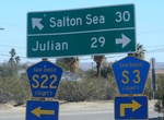
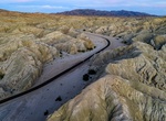
Drive Borrego Salton Sea Way (S-22), Borrego Springs, California
CR S22, Borrego Salton Sea Way, branches west off SR 86 at Salton City and heads into the heart of the Borrego Badlands towards Borrego Springs. The rugged Santa Rosa Mountains providing an impressive backdrop. If you have a 4WD vehicle, there are several great side trips along the way including: Peg Leg Smith Historical Marker Font's Point - especially at sunset... -
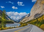
Drive Bow Valley Parkway, Banff National Park
The Lake Louise to Banff section of the Banff National Park 1A route is also known as the Bow Valley Parkway. It begins at Highway 1 at Lake Louise, generally paralleling it until it meets Highway 1 again approximately 6 km (3.7 mi) west of Banff. It provides more immediate access to attractions in Banff National Park such as Castle Mountain and Johnston Canyon. This ... -
Off-road Box Canyon at Hassayampa River, Wickenburg, Arizona
Box Canyon Hassayampa River is near Wickenburg, Arizona. The canyon allows riders to traverse up a dry and sandy river bottom, then find themselves in a narrow and wet river channel. -
Off-road Box Canyon (Florence), Tonto National Forest, Arizona
Box Canyon near Florence, Arizona is a popular off-roading spot for Phoenix adventurers, offering scenic trails from easy dirt roads to extreme obstacles like "Axel Alley," featuring diverse terrain (sand, rock, slot canyons), camping opportunities, and cooler temps at higher elevations, but requires an Arizona State Trust Land Permit and caution for flash floods, bes... -
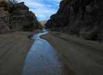
Drive Box Canyon Road, Mecca Hills, California
Box Canyon Road is a nice two lane road scenic off highway drive between I-10 and Mecca, California. It cuts through Mecca Hills. Box Canyon Road is used by hikers, campers, leisure travelers, and workers, with access to the Painted Canyons, a spectacular natural attraction in the eastern Coachella Valley. Box Canyon connects to Cottonwood Springs Road, which leads in... -
Off-road to Boxcar Cove & Crawdad Cove, Lake Mead, Nevada
Grab your sunscreen and beach chair and head out to Crawdad and Boxcar coves. Reached via boat or dirt road, these coves offer clear, clean water for taking a dip. While there are no designated campsites, dry camping is permitted for 7 days at Boxcar Cove and 15 days at Crawdad Cove. Access: Driving off of designated roads is prohibited. Located on Lake Mead on t...
Price: $211.46