Give us feedback!


 See all

Our philosophy is simple. We want to encourage you to dream. BIG! Then we help you plan your trip, get the most out of it while you're traveling and help you share your experience with friends.
Join Now It's FREE
Dream Packages
Duration: 12 hours
Price: $211.46
Price: $211.46
Duration: 12 hours 30 minutes
Price: $289.36
Price: $289.36
Duration: 12 hours
Price: $103.26
Price: $103.26
Duration: 10 hours 30 minutes
Price: $129.01
Price: $129.01
Dreams Still To Do
Checked-Off Dreams
Dreams Still To Do
Checked-Off Dreams
Advertisement
Explore Driving Experiences
-
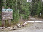
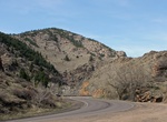
Off-road Barlow Road, Mount Hood, Oregon
The Barlow Road (at inception, Mount Hood Road) is a historic road in what is now the U.S. state of Oregon. It was built in 1846 by Sam Barlow and Philip Foster, with authorization of the Provisional Legislature of Oregon, and served as the last overland segment of the Oregon Trail. Its construction allowed covered wagons to cross the Cascade Range and reach the Willa... -
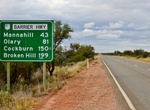
Drive Barrier Highway, New South Wales & South Australia
Barrier Highway is a highway in South Australia and New South Wales, and is designated part of route A32. The name of the highway is derived from the Barrier Ranges, an area of moderately high ground in the far west of New South Wales, through which the highway traverses. Barrier Highway branches off Horrocks Highway at Giles Corner, between Riverton and Tarlee, and h... -
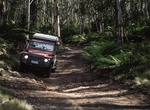
Off-road Barrington Trail, Barrington Tops National Park, NSW, Australia
If you’ve got power at all 4 wheels and a bit of clearance, you’ll want to time your trip between October and May when the Barrington 4WD trail is open to traffic. The 12.5km track winds through a unique mix of ferns and gums typical of Barrington, ending at Junction Pools campground (which is accessed via this trail). -
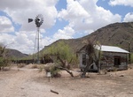
Off-road to Bates Well Ranch, Organ Pipe Cactus National Monument, Arizona
The Bates Well Ranch, also known as the Bates Well, Growler Well, Gray Ranch and El Veit, was one of the fifteen ranches and line camps in the Gray family cattle business in the Sonoran Desert country north of the US-Mexico border in Pima County, Arizona. Operating for nearly 60 years, the ranch is now part of Organ Pipe Cactus National Monument. The main ranch house ... -
Drive Bear Creek Canyon Scenic Mountain Drive, Colorado
Bear Creek Canyon Drive, a linear district, includes two miles of scenic road, which is now part of State Highway 74. The drive is between the town of Morrison and the town of Idledale. The scenic drive connects to the west border of the Red Rocks Mountain Park District. The Denver Mountain Parks owns a 200 feet (61 m) strip of canyon on both sides of Bear Creek. The ... -
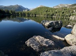
Drive to Bear Lake, Rocky Mountain National Park
Bear Lake is a scenic trailhead and destination in Rocky Mountain National Park. Sitting at an elevation of 9,450 feet (2,880 m), the alpine lake rests beneath the sheer flanks of Hallett Peak and the Continental Divide. Several trails, from easy strolls to strenuous hikes, start from the lake. The Bear Lake Road is open year round, though it may temporarily close due... -
Drive Beartooth Highway, Montana & Wyoming
The Beartooth Highway is an All-American Road that has been called "the most beautiful drive in America," by late CBS correspondent Charles Kuralt. Because of heavy snowfall at the top, the pass is usually open each year only from mid May through mid October, weather conditions permitting. The Beartooth Highway is the section of U.S. Highway 212 between Red Lodge, Mon... -
Off-road Bee Canyon Truck Trail, Hemet, California
4.1 mile BEE Canyon OHV Road runs from just north of State Route 74 (east of Cranston Fire Station) to the junction with San Jacinto Ridge OHV Road 5S09. Gets drivers from Hemet to Idyllwild. The routes is open to all vehicles. Vehicle registration or green/red sticker required for Off Highway Vehicles. -
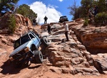
Off-road or Mountain Bike Behind the Rocks Safari Trail, Moab, Utah
Behind the Rocks 4x4 Trail is a 29.8 mile loop trail located near Moab, Utah. Inclused two of the most dangerous obstacles in Moab, High Dive and White Knuckle. Only extreme 4x4 vehicles should try this trail. Recommend the following 4x4 equipement: 2 Locking Differentials, 33" or Larger Tires, Winch, Oil Spill Containment Material. High possibility of rollover, break... -
Off-road to Bickel Camp, El Paso Mountains, California
Bickel Camp and its cabin is a historic 1930's era mining camp close to Ridgecrest, California, in the El Paso Mountains. Thanks to the Garlock fault, geothermal action, and other geological events, the El Paso Mountains are a picturesque, colorful, and mineralized area. Native Americans revered Black Mountain, the highest elevation within the El Paso range at just ov... -
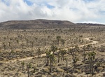
Off-road Big Bear’s Gold Fever Off Road Trail, California
Big Bear’s Gold Fever Trail is an 4WD 11-mile dirt road trail through Holcomb Valley that is only accessible with a high clearance. Explore the thriving gold rush area in the mid-1800’s. Holcomb Valley. It was here, in 1859, that Bill Holcomb discovered what was to become the richest gold field in southern California. There are still a few historic areas... -
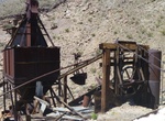
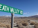
Off-road & Hike Big Bell Mine, Death Valley National Park, California
Big Bell Mine, Death Valley can be reach by 4WD road for about 13 miles to the top of the cable road (5,000 feet elevation) above the mine. Hike down to the mine at 3,600 feet. The drive passes the Chloride City ghost town. The Big Bell mine lay idle from 1912 to 1935, when the Coen Company acquired mining rights to the property. After a preliminary testing period, t... -
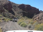
Off-road or Mountain Bike Bighorn Cove Road, Arizona
Bighorn Cove Road begins just south of Willow Beach and ends at Bighorn Cove on Lake Mohave. The road is a dirt road and can get pretty rocky in spots, but can be done with 2WD if you’re careful. Bikers, just look out for large or sharp rocks and for high-sitting vehicles. Access: From Willow Beach, take Jumbo Washington Road south for 1.7 miles. Turn right ... -
Off-road Bighorn Pass Road, Joshua Tree National Park
Bighorn Pass Road is a connector road between Big Horn Pass Road and Queen Valley Road. It can be a little sandy. -
Off-road Big Pine/Death Valley Road, Death Valley National Park, California
If you are coming south on the 396 from Mammoth or Reno and want to see the northern attractions of Death Valley National Park and want to do some offroading then this is the best way to enter the park. If ou plan on seeing Eureka Dunes, Racetrack Playa, Ubehebe Crater or Scottys Castle then this is the fastest way to get there from northern 395. Warning: The road mig...
Price: $133.44