Give us feedback!


 See all

Our philosophy is simple. We want to encourage you to dream. BIG! Then we help you plan your trip, get the most out of it while you're traveling and help you share your experience with friends.
Join Now It's FREE
Dream Packages
Duration: 10 hours
Price: $270.00
Price: $270.00
Duration: 10 hours
Price: $180.27
Price: $180.27
Duration: 10 hours 30 minutes
Price: $129.01
Price: $129.01
Duration: 12 hours
Price: $154.81
Price: $154.81
Dreams Still To Do
Checked-Off Dreams
Dreams Still To Do
Checked-Off Dreams
Advertisement
Explore Driving Experiences
-
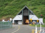
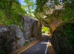
Drive through Anton Anderson Memorial Tunnel (Whittier Tunnel), Alaska
The Anton Anderson Memorial Tunnel, often called the Whittier Tunnel after the town at its eastern terminus, is a dual-use ("bimodal") highway and railroad tunnel that passes under Maynard Mountain. At a length of 13,300 ft (4,100 m), it is the second-longest highway tunnel and longest combined rail and highway tunnel in North America. The tunnel was upgraded to bimod... -
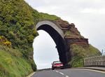
Drive Antrim Coast Road, Northern Ireland
The A2 is a major road in Northern Ireland, a considerable length of which is often referred to the Antrim Coast Road because it follows the scenic coastline of County Antrim. Mainly a single lane in each direction, the road follows most of the coastline of Northern Ireland. It is connected in several places to other major roads. The Antrim Coast Road is regarded as o... -
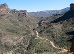
Drive Apache Trail, Arizona
Note: Road is closed indefinitely at Fish Creek Hill Overlook due to flood damage. Check here for current status. The Apache Trail, also known more officially as Arizona State Route 88, is a 40-mile drive starting in Apache Junction and ending at Theodore Roosevelt Dam. The Apache Trail in Arizona was a stagecoach trail that ran through the Superstition Mountains. It ... -
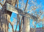
Drive Arch Canyon Road, Utah
Arch Canyon is a twelve mile long box canyon located north of highway 95. The canyon has beautiful redrock walls, and it is possible to see several arches. The creek that runs along the bottom of the canyon normally has water (all water should be treated prior to drinking). Look along the canyon walls for hanging gardens. As you look for hanging gardens, you are also ... -
Drive Arches Scenic Drive (Hwy 128), Arches National Park, Utah
The scenic drive in Arches passes many outstanding natural features. Parking is limited at all destinations, and popular trailheads like Delicate Arch and Devils Garden may fill for hours at a time, especially on weekends and holidays. If you have 1.5 hoursDrive to The Windows Section and see some of the park's largest arches. (Add a half hour to stroll beneath eithe... -
Drive though Arch Rock Entrance, Yosemite National Park, California
The Arch Rock Entrance, located on Highway 140 just past the entrance gate. A unique natural feature welcomes visitors to the park, via the Arch Rock entrance. Two house-sized boulders, situated on either side of the inbound road, form an archway for visitors to pass through. It's a truly exceptional experience upon first entering Yosemite National Park. -
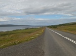
Drive Arctic Coast Way, Iceland
On June 8, 2019 Iceland is unveiling a rebranded Arctic Coast Way, which connect 21 villages, 17 communities, and four islands located along the 560-mile stretch of northern coastline spanning from Hvammstangi to Bakkafjörður. The route includes six peninsulas reaching far out in the ocean, taking you from black sandy beaches to spectacular cliffs, along glac... -
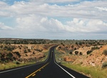
Drive Arizona State Route 77 (SR 77), Arizona
State Route 77 (SR 77) is a 253.93-mile (408.66-kilometre) long state highway in Arizona that traverses much of the state's length, stretching from its southern terminus at a junction with I-10 in Tucson to its northern terminus with BIA Route 6 at the Navajo Nation boundary just north of I-40. Between Tucson and the Navajo Nation, SR 77 passes through Oro Valley, Ora... -
Drive Arizona State Route 98 (SR 98), Arizona
State Route 98 (SR 98) is a state highway in Coconino County in the U.S. state of Arizona. SR 98 begins at an intersection with US 89 just south of the Glen Canyon Dam along the Colorado River. It runs along the southern portion of the city of Page and turns southeast to the Navajo Nation. It enters the town of Kaibito in the reservation, but otherwise the stretch thr... -
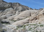
Off-road Arroyo Hueso, Anza-Borrego, Anza-Borrego Desert State Park, California
Hueso Arroyo is to the east of Palm Sprins/Mesquite Oasis along Vallecito Creek Road. Shortly after entering Arroyo Hueso, take the left fork. The trail on the right fork is pretty short walk and ends at a high canyon wall and narrow mud cave. -
Off-road to Arroyo Salado Trail to Pumpkin Patch, 17 Palms & 5 Palms Oasis, Anza-Borrego Park & Ocotillo Wells, California
To reach Pumpkin Patch, Seventeen Palms, Una Palma & Five Palms turn off S-22 at Truckhaven Rocks Campground. There is a sign for 17 Palms on the Arroyo Salado Wash. The drive to 17 Palms is very short from this point. This is a watering hole for the wildlife with a couple of palms in the area. You cannot camp at this spot. Continue on the main route for a short ... -
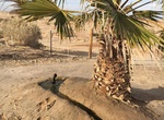
Off-road to Artesian Well (Ocotillo Wells SVRA), California
In 1919, a massive derrick was built here to drill for oil, but hit geothermal water instead. The well was abandoned and has since become a local landmark. A plane fuselage holds water and recently palm trees were planted. Panels here, and elsewhere, detail the captivating search for “black gold” at Ocotillo Wells. Accessed from the east end of Gas Domes T... -
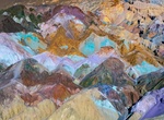
Drive Artist's Drive to Artist's Palette, Death Valley National Park, California
Artist's Drive rises up to the top of an alluvial fan fed by a deep canyon cut into the Black Mountains. Artist's Palette is on the face of the Black Mountains and is noted for having various colors of rock. These colors are caused by the oxidation of different metals (red, pink and yellow is from iron salts, green is from decomposing tuff-derived mica, and manganese ... -
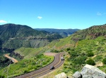
Drive through Atal Tunnel (Rohtang Tunnel), Himachal Pradesh, India
Atal Tunnel (also known as Rohtang Tunnel), named after former Prime Minister of India, Atal Bihari Vajpayee is a highway tunnel built under the Rohtang Pass in the eastern Pir Panjal range of the Himalayas on the National Highway 3 in Himachal Pradesh, India. At a length of 9.02 km, it is the highest highway single-tube tunnel above 10,000 feet (3,048 m) in the world... -
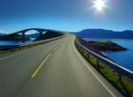
Drive Atlantic Ocean Road (Atlanterhavsveien), Norway
The Atlantic Ocean Road or the Atlantic Road (Atlanterhavsveien) is a 8.3-kilometer (5.2 mi) long section of County Road 64 which runs through an archipelago in Eide and Averøy in Møre og Romsdal, Norway. It runs along the unsheltered Hustadvika between the villages of Kårvåg on Averøy with Vevang in Eide, and is a fixed link connectin...


Price: $289.36