Give us feedback!


 See all

Our philosophy is simple. We want to encourage you to dream. BIG! Then we help you plan your trip, get the most out of it while you're traveling and help you share your experience with friends.
Join Now It's FREE
Dream Packages
Duration: 12 hours
Price: $103.26
Price: $103.26
Duration: 8 hours
Price: $133.44
Price: $133.44
Duration: 12 hours 30 minutes
Price: $289.36
Price: $289.36
Duration: 3 days
Price: $559.53
Price: $559.53
Dreams Still To Do
Checked-Off Dreams
Dreams Still To Do
Checked-Off Dreams
Advertisement
Explore Driving Experiences
-
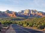
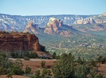
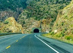
Drive Boynton Pass Loop Scenic Drive, Sedona, Arizona
Boynton Pass Loop Scenic Drive goes past spectacular views of Boynton Canyon and Dry Creek just northwest of the town of Sedona, Arizona. Pass by colorful canyons, red rock pinnacles, and high mountains. -
Off-Road Bradshaw Trail National Scenic Byway, California
The Bradshaw Trail, nicknamed the Gold Road at one time, is an historic overland stage route in Southern California which originally connected San Bernardino, California to gold fields in La Paz, Arizona Territory some 5 miles northeast of Ehrenberg, and the road to the mining districts of Central Arizona Territory, near Wickenburg and Prescott. In later years it was ... -
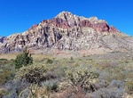
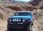
Off-road Bridge Mountain Trail, Red Rock Canyon, Nevada
Bridge Mountain Trail is accessible from the summit of Rocky Gap Road. Difficulty: challenging. Off-road/4x4 required. -
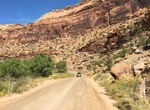
Off-road Bridger Jack Road & Beef Basin Road Loop
This challenging 74-mile loop trail near Monticello, Utah. The road starts off Park Hwy (211) about 21 miles from US Route 191. There is a restroom at this turn off. The road is suitable for both 2 and 4WD vehicles but may be muddy after inclement weather. The road climbs to over 8000 feet and may be impassable in winter months and the National Park Service Canyonlan... -
Off-Road or Hike Broken Arrow Trail, Sedona, Arizona
Broken Arrow Trail near Sedona is considered one of the best in Arizona. It's an extremely popular route and traffic can be very heavy at times. Many hikers will avoid this trail because of the jeep traffic on a road parallel to the trail, but it's still a great hike. At 0.6 miles, look for the fence around Devil's Dining Room Sinkhole 100 feet to the left and downhi... -
Off-road to Brooklyn Mine & Gold Standard Mine, California
4X4 to the Brooklyn Mine & Gold Standard Mine off the Brooklyn Mine Jeep Trail (aka Mecca Dale Road) just outside of Joshua Tree National Park. Other mines in the area are Los Angeles Mine and Rose of Peru Mine. Start the drive at the dirt Old Dale Road turn off from the paved Pinto Basin Road in Joshua Tree National Park. Turn onto Brooklyn Mine Jeep Trail 11.4 m... -
Off-road Buckhorn Draw Road, Utah
Buckhorn Draw Road (Buckhorn Wash Road) is the main route through the northern half of the San Rafael Swell. Sites include mines, old bridges and pictographs. -
Drive Buckman Springs Road (S1), San Diego, California
County Route S1, also known as Sunrise Highway for a portion of its length, is a 34.08 mi (54.85 km) long county route located entirely in San Diego County, California. It begins at SR 94 near Barrett and moves northward across Interstate 8, just west of the Laguna Summit. This segment is also known as Buckman Springs Road. North of I-8, it is the Sunrise Scenic Byway... -
Drive Buffalo Bill Cody Scenic Byway, Wyoming
Buffalo Bill Cody Scenic Byway is in the U.S. state of Wyoming and spans most of the distance from Cody, Wyoming to Yellowstone National Park. The 27.5-mile (44.3 km) scenic highway follows the north fork of the Shoshone River through the Wapiti Valley to Sylvan Pass and the eastern entrance to Yellowstone. Most of the scenic byway is contained within Shoshone Nationa... -
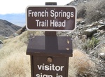
Off-road to Burgess Mine (French Spring Trail), Inyo Mountain Wilderness Area, California
The Burgess Mine Trail is located in the Inyo Mountain Wilderness Area. This 8.0-mile long trail starts at 4,600 feet at the end of the French Spring Road in Owens Valley. -
Drive Burkett Road, Western Australia
Burkett Road is a main east-west road in Exmouth Gulf near the northern edge of the Gascoyne. It links North West Coastal Highway with Minilya–Exmouth Road. -
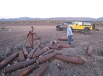
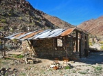
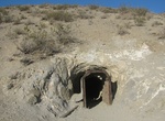
Off-road to Burro Schmidt Tunnel, California
The historic Burro Schmidt Tunnel is located in the El Paso Mountains of the northern Mojave Desert, in eastern Kern County, Southern California. It is a 0.5 miles (0.80 km) mining tunnel dug with hand tools and dynamite over a 38-year period by William "Burro" H. Schmidt (1871–1954) in the El Paso Mountains of eastern California. The tunnel is below the summit ... -
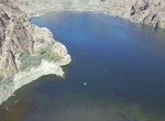
Off-road to Burro Wash, Colorado River, Nevada
The end of the trail at Burro Wash is a great place for picnicking, relaxing and even taking a quick dip! Just make sure you’re equipped to reach it. The road to Burro Wash requires a 4x4 vehicle and will take you down some rocky descents, sandy washes and over a few minor (but fun) rock obstacles. Don’t forget your chairs, shade and lunch! Access: Burro... -
Off-road Burro Wash 4x4 Trail, Colorado River, Nevada
Burro Wash 4x4 Trail is an out-and-back trail that starts just south of Boulder City and ends at the Colorado River, so be sure to pack a picnic, swim gear and some shade. The trail will have some minor washed-out areas, slightly off-camber spots and minor rocky obstacles, but is considered moderate and fun. You can expect to initially follow a dirt and rock trail alo... -
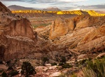
Drive Burr Trail Road in Capitol Reef National Park
The Burr Trail road in Capitol Reef National Park, Utah was originally a cattle trail blazed by stockman John Atlantic Burr, extends from the town of Boulder on Utah Hwy 12 to the Notom-Bullfrog Road, and continues to the Bullfrog Marina and Glen Canyon National Recreation Area. Views of the Henry Mountains, the colorfully contorted Waterpocket Fold, red Circle C...
Price: $229.00