Give us feedback!


 See all

Our philosophy is simple. We want to encourage you to dream. BIG! Then we help you plan your trip, get the most out of it while you're traveling and help you share your experience with friends.
Join Now It's FREE
Dream Packages
Duration: 3 days
Price: $604.38
Price: $604.38
Duration: 12 hours
Price: $154.81
Price: $154.81
Duration: 3 hours
Price: $312.25
Price: $312.25
Duration: 4 days
Price: $1457.59
Price: $1457.59
Dreams Still To Do
Checked-Off Dreams
Dreams Still To Do
Checked-Off Dreams
Advertisement
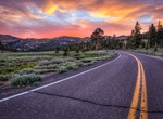
Explore Driving Experiences
-
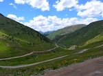
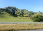
Off-road California Gulch Road, Colorado
This trail is absolutely beautiful from start to finish. Though it isn't a technically challenging trail it does follow very narrow shelf roads. All drivers will need to be very careful. You can start at either end. This means you can start at Animas Forks at the intersection of California Gulch, Cinnamon Pass and Engineer Pass, or you can start at Lake Como at the i... -
Drive California Incline, Santa Monica, California
The California Incline is a slanted road in Santa Monica, California, connecting Ocean Avenue with State Route 1 (Pacific Coast Highway or PCH). It technically is the last link, the western end of California Avenue, a minor east–west street in Santa Monica. The California Incline was originally a walkway known as Sunset Trail, which was cut through the blu... -
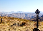
Hike or Ride California Riding and Hiking Trail (Chariot & Banner Canyons), California
The California Riding and Hiking Trail has its own interesting history. The vision for it began in 1945 when the state Legislature passed the California Riding and Hiking Trails Act, calling for a single 3,000-mile loop trail from Mexico to the Oregon border. By the 1960s, some 1,060 miles of the trail had been completed statewide. In San Diego, 108 miles of the trail... -
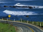
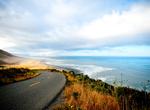
Drive California Route 1 (PCH) - Morro Bay to Monterey, California
State Route 1 (SR 1) is a major north-south state highway that runs along most of the Pacific coastline of the U.S. state of California. Highway 1 has several portions designated as either Pacific Coast Highway (PCH), Cabrillo Highway, Shoreline Highway, or Coast Highway. Its southern terminus is at Interstate 5 (I-5) near Dana Point in Orange County and its northern ... -
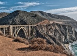
Drive California Route 1 (PCH) - San Francisco to Los Angeles
State Route 1 (SR 1), more often called Highway 1, is a state highway that runs along much of the Pacific coast of the U.S. state of California. It is famous for running along some of the most beautiful coastlines in the world, leading to its designation as an All-American Road. Highway 1 has several portions designated as either Pacific Coast Highway (PCH), the Cabri... -
Explore California's Lost Coast, California
Northern California's Lost Coast starts where Highway 1 end, defeated by mountains that rise nearly straight out of the water. The Lost Coast is a mostly undeveloped section of the California North Coast in Humboldt and Mendocino Counties, which includes the King Range. It was named the "Lost Coast" after the area experienced depopulation in the 1930s. In addition, th... -
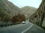
Drive California State Route 108, California
State Route 108 (SR 108) is a state highway in the U.S. state of California that runs from the Central Valley and across the Sierra Nevada via the Sonora Pass. It generally runs northeast from downtown Modesto near the SR 99/SR 132 interchange, to U.S. Route 395 near the Nevada state line. The route was once recommended to continue south of Modesto to Interstate 5, al... -
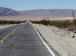
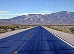
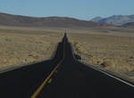
Drive California State Route 127, California
State Route 127 (SR 127) is a state highway in the U.S. state of California that connects Interstate 15 in Baker to Nevada State Route 373 at the Nevada state line, passing near the eastern boundary of Death Valley National Park. The entire length of the highway closely follows the central portion of the former Tonopah and Tidewater Railroad and loosely follows the Am... -
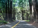
Drive California State Route 128
State Route 128 (SR 128) is a state highway in the U.S. state of California, connecting the Mendocino coast to the Central Valley through the state's Wine Country. Route 128 begins at Route 1 near the mouth of the Navarro River at the Pacific Ocean. The highway travels upriver through the coast redwood forests of Navarro River Redwoods State Park and through the viney... -
Drive California State Route 152
State Route 152 (SR 152) is a state highway that runs near the latitudinal middle of the U.S. state of California from Watsonville to Route 99 southeast of Merced. Its western portion (which is also known as Pacheco Pass Road and Pacheco Pass Highway) provides the best access to and from Interstate 5 toward southern California for motorists in or near San Jose. This r... -
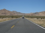
Drive California State Route 178 (Bakersfield to Trona), California
State Route 178 (SR 178) is a state highway in the U.S. state of California that exists in two constructed segments. The gap in between segments is connected by various local roads and State Route 190 through Death Valley National Park. The western segment runs from State Route 99 in Bakersfield and over the Walker Pass in the Sierra Nevada to the turnoff for the Tron... -
Drive California State Route 178 (Death Valley to Nevada), California
State Route 178 (SR 178) is a state highway in the U.S. state of California that exists in two constructed segments. The gap in between segments is connected by various local roads and State Route 190 through Death Valley National Park. The western segment runs from State Route 99 in Bakersfield and over the Walker Pass in the Sierra Nevada to the turnoff for the Tron... -
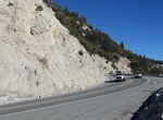
Drive California State Route 18 (CR 18), California
California State Route 18 (SR 18) is a state highway in the U.S. state of California. It serves as a primary route into the San Bernardino Mountains, both from the Riverside–San Bernardino metropolitan area from the south and the Mojave Desert from the north. SR 18 runs from State Route 210 in San Bernardino to State Route 138 in Llano. It has two discontinuitie... -
Drive California State Route 190, California
State Route 190 (SR 190) is a state highway in the U.S. state of California that is split into two parts by the Sierra Nevada. The western portion begins at Tipton at a junction with State Route 99 and heads east towards Porterville before ending at Quaking Aspen in the Sequoia National Forest. The eastern portion begins at US 395 at Olancha, heads east through Death ... -
Drive California State Route 247 (Old Woman Springs Road), California
California State Route 247 (SR 247) is a state highway in the U.S. state of California. The road passes through the Mojave Desert in San Bernardino County, connecting SR 62 in Yucca Valley to Interstate 15 (I-15) in Barstow. SR 247 runs along Old Woman Springs Road between Yucca Valley to Lucerne Valley, and Barstow Road between Lucerne Valley and Barstow. SR 247 was ...

Price: $199.57