Give us feedback!


 See all

Our philosophy is simple. We want to encourage you to dream. BIG! Then we help you plan your trip, get the most out of it while you're traveling and help you share your experience with friends.
Join Now It's FREE
Dream Packages
Duration: 2 days
Price: $335.27
Price: $335.27
Duration: 10 hours 30 minutes
Price: $129.01
Price: $129.01
Duration: 3 hours
Price: $120.56
Price: $120.56
Duration: 8 hours
Price: $133.44
Price: $133.44
Dreams Still To Do
Checked-Off Dreams
Dreams Still To Do
Checked-Off Dreams
Advertisement
Explore Driving Experiences
-
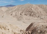
Off-road to Cannonball Wash & Diablo Formation, California
Off-road to the aptly named Cannonball Wash where an amazing collection of large and small, sometimes-round, sometimes very oddly-shaped concretions . -
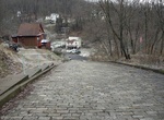
Go up Canton Avenue, Pittsburgh, Pennsylvania
Canton Avenue, in Pittsburgh, Pennsylvania's Beechview neighborhood, is the steepest officially recorded public street in the United States. Canton Avenue is 630 ft (190 m) long (the hill is about 65 meters long) and is claimed to include a 37 percent grade 21 ft (6.4 m) feet long. According to the Guinness Book of World Records, Baldwin Street, in Dunedin, New Zealan... -
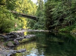
Drive Canton Creek Road, Oregon
Travelers crossing the Cascade Mountainss on Oregon’s North Umpqua Highway 138 – also known as the Rogue-Umpqua National Scenic Byway – might easily miss Canton Creek, a tributary of Steamboat Creek and the North Umpqua River. A visit to Canton Creek is well worth the effort, though - and just a short drive north of the community of Steamboat, known... -
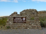
Drive Canyon Loop Drive, Chaco Culture National Historical Park, New Mexico
Six major sites are located along the 9-mile long Canyon Loop Drive. These sites include Una Vida, Hungo Pavi, Pueblo Bonito, Chetro Ketl, Pueblo del Arroyo, and Casa Rinconada. You may purchase self-guided trail guides at the Visitor Center bookstore. Loop Road will remain open from 7:00 am until close (hours listed above), with the entrance gate to Loop Road closin... -
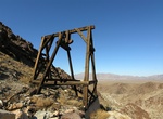
Drive Canyon Of Gold Auto Tour (Bullion Canyon), Utah
From at least 1865, flecks of gold in the creek and veins of gold inside her walls have drawn the hopeful to this canyon by the thousands. This is a driving tour along national forest roads that passes many buildings, mines, and other cultural history artifacts. Use the list below to access each of the stops along the Canyon of Gold Driving Tour. Toll Road Mill S... -
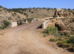
Hike or Off-road to Canyon Padre Bridge, Arizona
Luten arch bridge over Padre Canyon on an old alignment of Route 66. To get t the bridge take the Winona exit off Interstate 40 and double back east on the north frontage road. -
Drive Cape Borda Road, Kangaroo Island, South Australia
Cape Borda Lighthouse (formerly known as the Flinders Light) is a lighthouse in the Australian state of South Australia located at Cape Borda on Kangaroo Island. Located on the north western corner of Kangaroo Island, this unique square lighthouse was built in 1858 and is steeped in European history. The road can be rough a... -
Drive Cape Royal Road, Grand Canyon National Park, Arizona
Cape Royal on the North Rim provides a panorama up, down, and across the canyon. With seemingly unlimited vistas to the east and west, it is popular for both sunrise and sunset. The sweeping turn of the Colorado River at Unkar Delta is framed through the natural arch of Angels Window. Look for the Desert View Watchtower across the canyon on the South Rim. This popular... -
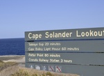
Drive Cape Solander Drive, Kurnell, New South Wales, Australia
Head to one of Sydney's best whale watching spots. Cape Solander, located in the Kurnell section of Kamay Botany Bay National Park is an unbeatable lookout during whale watching season. If you're driving into the Kurnell area of Kamay Botany Bay National Park please note that gates are open: 7am-7.30pm (August to May) 7am-5.30pm (June to July) -
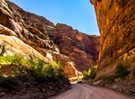
Drive Capitol Gorge Road, Capitol Reef National Park, Utah
The Capitol Gorge Road dirt road is located in the southern part of Capitol Reef National Park. The Capitol Gorge spur road was a through road from 1884 to 1962, the drive now ends in a few miles. From there you get out and hike the rest of the way through the Gorge. On this hike you see historic inscriptions from pioneers of the 19th and 20th century who traveled alo... -
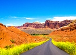
Drive Capitol Reef Road (Route 24), Utah
Capitol Reef Road (Route 24) is a road that cuts through the mountains at Capitol Reef National Park, Utah. This all-weather State Route 24 was built in 1962 through the Fremont River canyon near Fruita. State Route 24 replaced the narrow Capitol Gorge wagon road about 10 mi (16 km) to the south that frequently washed out. The old road has since only been open to foot... -
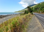
Drive Captain Cook Highway, Queensland, Australia
The Captain Cook Highway is a short, regional highway in Queensland which originates in Cairns and terminates in Mossman, where it joins Mossman-Daintree Road, continuing to Daintree. The Captain Cook Highway is used to connect the CBD of Cairns to the Northern Beaches; a collection of suburbs which comprise the northern section of Cairns. It is also used by many tour... -
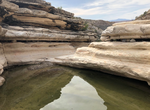
Off-road to Carlota Tinaja, Big Bend National Park, Texas
Tinaja Carlota is located along the dirt Old Ore OHV Road and is similar to nearby Ernst Tinaja. Tinaja is Spanish for a tank or pool. -
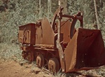
Off-road & Hike Carlysle Mine, 29 Palms, California
Carlysle Mine is located 7 miles northwest of New Dale. It consisted of two tunnels; the upper following 1,200 feet along the vein and the lower 1,500 feet long with crosscuts, drifts and saises. A 2,680 foot long aerial tram connecting the mine to the mill. A puming plant was built on the southwest shore of Sale Dry Lake with a 3" pipeline to the mill. It was last op... -
Drive Carretera Austral (Route 7), Chile
The Carretera Austral (CH-7,in english: Southern Way) is the name given to Chile's Route 7. The highway runs south for about 1,240 kilometers (770 mi) from Puerto Montt to Villa O'Higgins, passing through rural Patagonia. The 130-140 km from Caleta Tortel to the end in Villa O'Higgins is the wildest and remotest stretch of the highway. Carretera Austral provides road...
Price: $229.00