Give us feedback!


 See all

Our philosophy is simple. We want to encourage you to dream. BIG! Then we help you plan your trip, get the most out of it while you're traveling and help you share your experience with friends.
Join Now It's FREE
Dream Packages
Duration: 10 hours 30 minutes
Price: $129.01
Price: $129.01
Duration: 14 hours
Price: $551.14
Price: $551.14
Duration: 4 days
Price: $772.57
Price: $772.57
Duration: 3 days
Price: $604.38
Price: $604.38
Dreams Still To Do
Checked-Off Dreams
Dreams Still To Do
Checked-Off Dreams
Advertisement
Explore Driving Experiences
-
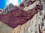
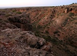
Off-road to Cedar Canyon Petroglyphs, Wyoming
The Cedar Canyon Petroglyphs are dated back more than 200 years, with some of the petroglyphs unique to this location, including several panels that include depictions of plants and markings referred to as calendars. Cedar Canyon is south of Fifteenmile Knoll and southwest of Pine Canyon. Cedar Canyon has an elevation of 6,542 feet. The panels are a 250 ft uphill wal... -
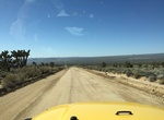
Drive Cedar Canyon Road, Mojave Desert, California
Cedar Canyon Road is a mostly unpaved 33.47km (20.8 miles) scenic drive running east-west across the central part of the Mojave National Preserve, connecting Kelso Cima Road with Lanfair Road. -
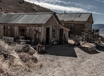
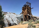
Off-road to Cerro Gordo Mines, California
The Cerro Gordo Mines are a collection of abandoned mines located in the Inyo Mountains, in Inyo County, California. Mining operations were undertaken from 1866 until 1957, producing high grade silver, lead, and zinc ore. Some ore was smelted on site, but larger capacity smelters were eventually constructed along the shore of nearby Owens Lake. These smelting operatio... -
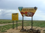
Drive Chain of Craters Backcountry Byway, New Mexico
The Chain of Craters Backcountry Byway is a 33-mile backcountry byway located in El Malpais National Conservation Area (NCA) and National Monument in northwestern New Mexico. The byway, which is County Road 42, passes almost exclusively through public lands. County Road 42 forms the western boundary of the West Malpais Wilderness and connects NM 53 and NM 117. The C... -
Drive Chain of Craters Road, Hawaii Volcanoes National Park
Chain of Craters Road is a 19-mile winding paved road through the East Rift and coastal area of the Hawaii Volcanoes National Park on the island of Hawaii, in the state of Hawaii, United States. The original road, built in 1928, connected Crater Rim Drive to Makaopuhi Crater. The road was lengthened to reach the tiny town of Kalapana in 1959. The road has had parts co... -
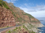
Drive or Cycle Chapman's Peak Drive, South Africa
Chapman's Peak is the name of a mountain on the western side of the Cape Peninsula, about 15 kilometres south of Cape Town, South Africa. It is opposite the inlet on which the town of Hout Bay is centred. The western flank of the mountain falls sharply for hundreds of metres into the Atlantic Ocean. A spectacular road, known as Chapman's Peak Drive, hugs the near-vert... -
Off-road Chappie-Shasta OHV Area, Shasta Lake, California
Visitors to the rolling, brushy hills near Shasta Lake in northern California will find off-highway vehicle (OHV) riding challenges for all abilities. More than 250 miles of roads and trails are open to motorcyclists, all-terrain vehicle drivers and four-wheelers. The area is near massive Shasta Dam and Shasta Lake, and there are overlooks of the Sacramento River belo... -
Drive Charles Knife Gorge Rd, Cape Range National Park, Western Australia
The Charles Knife Canyon drive takes you on a winding road from the main road south of Exmouth up to the top of the range. Located at the top is Charles Knife lookout. The Charles Knife Canyon includes a picnic area and the historical Wapet Oil Well No. 3 site. Visitors can also walk the Badjirrajirra Loop Trail via the picnic area. For more information on this wal... -
Off-road to Chemung Mine, Bridgeport, California
Located off the Masonic Road between Bridgeport, CA and the Masonic town site, are the remains of the Chemung gold mine. The Chemung gold mine operated from from 1909 to 1938 and produced over one million dollars in gold. In the 1920s, the Chemung mine was producing low grade and high grade ore. The ore was processed onsite, and then shipped to near by Bodie for smelt... -
Drive Cherokee Orchard Road, Great Smoky Mountains National Park
Cherokee Orchard Road povides access to Rainbow Falls Trail and Roaring Fork Motor Trail. -
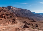
Off-road or Mountain Bike Chicken Corners Safari Trail & Kane Springs Road, Moab, Utah
Chicken Corners Safari Trail is a very popular ATV, UTV and dirt bike area near Moab, Utah. Descend the dramatic west side of Hurrah Pass to the Colorado River. Explore natural caves at Catacomb Rock. From Chicken Corners, look across river to see dramatic Thelma & Louise Point. Camp in designated sites only in Kane Creek Canyon. -
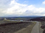
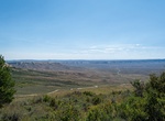
Drive Chicken Creek Road Scenic Drive, Fossil Butte National Monument, Wyoming
A 5.5 mile scenic drive (2.5 miles paved, 3 miles improved gravel) provides scenic views of Fossile Butte, the Wasatch Formation badlands and wildlife. CAUTION: The gravel road begins with a 17% grade. Moter homes and vehicles towing trailers are encouraged to turn around at the picnic area. There are a few side dirt roads along the route: Cundick Ridge Road - 4... -
Drive Chief Joseph Scenic Highway (HWY 296), Wyoming
Wyoming Highway 296 also known as the Chief Joseph Scenic Highway is in the U.S. state of Wyoming and follows the route taken by Chief Joseph as he led the Nez Perce Indians out of Yellowstone National Park and into Montana in 1877 during their attempt to flee the U.S. Cavalry and escape into Canada. Access to Yellowstone National Park's northwest entrance is off the ... -
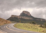
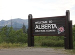
Drive or Ride Chief Mountain Highway, US & Canada
The Chief Mountain Highway offers exhilarating vistas of the Waterton and Blakiston valleys. The Chief Mountain Highway is the primary route between Waterton Lakes National Park and Glacier National Park (U.S). The highway climbs from the grasslands near Maskinonge Lake to a viewpoint which offers a magnificent panorama of the Waterton and Blakiston valleys (Chief Mou... -
Drive China Hat Road, Deschutes National Forest, Oregon
China Hat Road, named after the butte, starts in Bend and heads to Fort Rock. The road is a hotspot for law enforcement. China Hat Campground is a campground located near China Hat butte along this road.
Price: $499.00