Give us feedback!


 See all

Our philosophy is simple. We want to encourage you to dream. BIG! Then we help you plan your trip, get the most out of it while you're traveling and help you share your experience with friends.
Join Now It's FREE
Dream Packages
Duration: 8 hours
Price: $133.44
Price: $133.44
Duration: 4 days
Price: $772.57
Price: $772.57
Duration: 12 hours
Price: $103.26
Price: $103.26
Duration: 3 days
Price: $559.53
Price: $559.53
Dreams Still To Do
Checked-Off Dreams
Dreams Still To Do
Checked-Off Dreams
Advertisement
Explore Driving Experiences
-
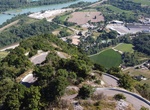
Ride or Drive up Col du Grand Colombier, Jura mountains, France
Col du Grand Colombier (el. 1,501 metres or 4,925 feet) is a mountain pass in the Jura mountains in France. This pass lies at the southern extremity of the Jura in the massif of the Grand Colombier. With the Col du Chasseral, it is the highest road pass in the Jura. It passes between the Grand Colombier (el. 1,531 m (5,023 ft)) and the Croix du Colombier (1,525 m (5,0... -
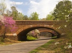
Drive Colonial Parkway, Virginia
Colonial Parkway is a 23-mile (37 km) scenic parkway linking the three points of Virginia's Historic Triangle, Jamestown, Williamsburg, and Yorktown. It is part of the National Park Service's Colonial National Historical Park. With portions built between 1930 and 1957, the Colonial Parkway links the three communities via a roadway carefully shielded from views of comm... -
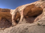
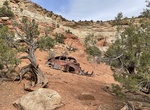
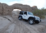
Off-road & Hike to Colonnade Arch (Five Hole Arch), Utah
Colonnade Arch, or Five Hole Arch as it is also commonly known by, is a stunning arch high above the Green River and Two Mile Canyon. This hike features incredible views of Canyonlands National Park the La Sal Mountains and the Green River. It's about 40 miles south of Green River, Utah. The hike to Colonnade Arch begins on Keg Knoll in a remote section of the San R... -
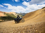
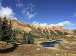
Off-road Colorado Backcountry Discovery Route (COBDR), Colorado
This trip can take a lot of planning. Make sure to check out https://ridebdr.com/cobdr/ for more details. The full route can take 5-10 days depending on how many side trips you make. The trail starts at Four Corners Monument, where the borders of New Mexico, Arizona, Utah and Colorado converge. The 744 mi (1,200 km) route winds its way north through the Rocky Mountai... -
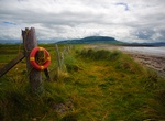
Drive to Coney Island (Inishmulclohy), Sligo, Ireland
Coney Island or Inishmulclohy, in County Sligo, Ireland, is one of several islands of the same name off the coast of Ireland. It is an island of approximately 400 acres and is named after the vast quantity of rabbits which can be spotted on the island at any time (Coney (/ˈkoʊni/, historically /ˈkʌni/) is an English word for a rabbit or rabbit hair, deriving from the ... -
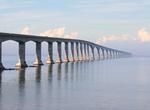
Drive across Confederation Bridge, Canada
The Confederation Bridge is a bridge spanning the Abegweit Passage of Northumberland Strait, linking Prince Edward Island with mainland New Brunswick, Canada. It was commonly referred to as the "Fixed Link" (cf. fixed link) by residents of Prince Edward Island prior to its official naming. The 12.9-kilometre (8 mi) long bridge opened on 31 May 1997. The bridge is a tw... -
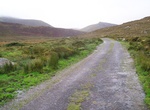
Drive Conor Pass, Dingle Peninsula, Ireland
The Conor Pass is the highest mountain pass in Ireland. It is situated on the Dingle Peninsula in County Kerry, on the road that crosses the peninsula between Dingle Town and the coast the other side. The road which runs from Dingle on the south-western end of the peninsula towards Brandon Bay and Castlegregory in the north-east The Mountains the Pass crosses are the... -
Off-road to Copper Globe Mine, San Rafael Swell, Utah
The Copper Globe mining area provides visitors with an opportunity to explore standing structures and features associated with a historic mine in operation from 1900-1905. While no copper was actually successfully smelted due to the low quality of the ore, the tale of the site is interesting in itself. Features at the site include a 75’ foot pile of logs used to... -
Off-road to Coral Wash Arch (Truckhaven Arch), Ocotillo Wells SVRA, California
This astounding arch is found along Coral Wash, one of the drainage channels in the northern area of Ocotillo Wells SVRA known locally as “Truckhaven.” Driving up Coral Wash offers the challenge of a variety of technical OHV maneuvers as one winds through the narrow walls lined with prehistoric layers -
Off-road Corkscrew Gulch Road, Colorado
This scenic trail cuts through the heart of old mining country as it winds between Red Mountain #1 and #2. Watch for logging trucks on lower part of trail. You can park and camp at bottom end of trail off Highway 550. From the bottom, you can also explore Brown Mountain and Gray Copper Gulch, which is left at the first major fork, marked as Brown Mountain. This side r... -
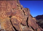
Off-road to Corn Springs, California
Corn Springs is a palm oasis situated in the Chuckwalla Mountains of the Colorado Desert in Riverside County, California, United States, seventeen miles southeast of Desert Center. Native Americans relied on the springs, and they engraved many petroglyphs on the rocks in the area. In the late 19th century, miners in the area also relied on the springs, and they establ... -
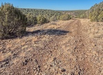
Off-road Corva Road, Arizona
Corva Road is access it from old Route 66. Corva was a populated place situated in Coconino County, Arizona. It has an estimated elevation of 6,227 feet (1,898 m) above sea level. Corva was situated along the Santa Fe railroad. In 1913, houses were completed and occupied for area railroad workers. High clearance vehicle required. -
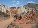
Drive Cottonwood Canyon Road (Road 400), Utah
Road 400 (Cottonwood Canyon Road) is a scenic 47-mile (76 km) dirt road connecting U.S. Highway 89 with Utah S.R 12 at Cannonville. It traverses portions of Grand Staircase-Escalante National Monument offering a unique view into the heart of the Monument. This road is considered impassable in wet weather and high clearance vehicles are recommended. Patient drivers of ... -
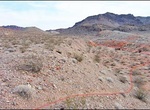
Off-road to Cottonwood East (Pot Cove), Arizona
This road is great as a break from the hustle and bustle of Vegas, and an excellent place to enjoy stunning views. Entirely dirt, Cottonwood Road’s eastern half is smooth and well-traveled but still requires 4WD. Once you climb up into the Black Mountains, the terrain and road get more rough and washboard-like before descending toward Lake Mohave. Look up around... -
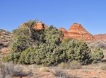
Off-road Cottonwood Spring Road, Coyote Buttes South, Arizona
Cottonwood Spring Road starts at the end of Paw Hole Road (BLM 1079 in Coyote Buttes South, Arizona. To access Cottonwood Spring Road take Paw Hole Road (BLM 1079) near the soutern part of House Rock Valley Road. From the north take House Rock Valley Road 16.5 miles to Paw Hole Road (BLM 1079) and turn left. If coming from the south at 89A take House Rock Road 13.2 m...
Price: $129.01