Give us feedback!


 See all

Our philosophy is simple. We want to encourage you to dream. BIG! Then we help you plan your trip, get the most out of it while you're traveling and help you share your experience with friends.
Join Now It's FREE
Dream Packages
Duration: 12 hours
Price: $103.26
Price: $103.26
Duration: 6 hours
Price: $162.00
Price: $162.00
Duration: 10 hours
Price: $180.27
Price: $180.27
Duration: 9 hours
Price: $229.00
Price: $229.00
Dreams Still To Do
Checked-Off Dreams
Dreams Still To Do
Checked-Off Dreams
Advertisement
Explore Driving Experiences
-
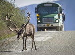
Ride Denali Park Shuttle Bus, Alaska
On a clear day, this 8-hour shuttle bus trip into the park offers outstanding views of Denali and the Alaska Range, and excellent wildlife viewing opportunities. Destination/Service: Toklat River (Mile 53) Eielson Visitor Center (Mile 66) Wonder Lake (Mile 85) Kantishna (Mile 92) All non-narrated buses, called transit or shuttle buses, are designed to move people a... -
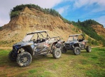
ATV Denali Toy Rentals, Healy, Alaska
ATV rental service in the Healy, Alaska -
Drive Deschutes River Backcountry Byway, Oregon
From the Oregon-Washington border past the whitewater rafting community of Maupin, the BLM manages dozens of camping sites, boat ramps and picnic areas along the Deschutes. Also along the river is the 34-mile-long Deschutes River Backcountry Byway. The 9-mile-long paved section ends at Sherars Falls, where Native Americans still fish for salmon using traditional plat... -
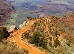
Drive Desert View Drive, Grand Canyon National Park, Arizona
Desert View Drive is a scenic route to the east of Grand Canyon Village on the South Rim which follows the rim for 25 miles (40 km) out to the Desert View Watchtower and East Entrance. While Hopi Point is unquestionably a desirable viewpoint for sunset, it attracts crowds of people and buses, especially in the summer. Yaki and Pima Points offer spectacular views ... -
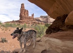
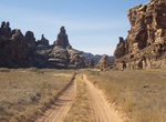
Off-road to Determination Towers, Utah
Determination Towers are located near Moab, Utah near the Mill Canyon Road. Dirt and sand road. Some points are pretty narrow -
Off-road Devil’s Canyon 4x4 Road, Colorado
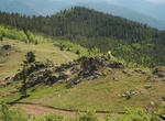
A fun loop with several side roads to explore. Trail is open to motorized traffic June 15 through Nov. 15. Gate is locked the rest of the year. Broad views from top of mountain. Parking along Highway 103 near start of trail. Before or after you drive this trail, consider a trip to Echo Lake and Mt. Evans, just another 2.5 miles past the trailhead on Hwy. 103. Fun area... -
Off-road Devils Canyon (Jacumba Mountains), San Diego County, California
Devils Canyon is a steep canyon in the Jacumba Mountains in Imperial and San Diego County, California. Its mouth is located at an elevation of 1,109 feet (338 m) in Imperial County. Its head is at an elevation of 3,560 feet (1,090 m) in the Jacumba Mountains in San Diego County. From 1862 Devils Canyon was the route of a wagon road between San Diego and Yuma, Arizona... -
Off-road & Hike Devils Canyon & Meyer Creek Loop, San Diego County, California
Devils Canyon runs from Mountain Springs, off Interstate 8, to Ocotillo just East of the San Diego/Imperial County line. Descend Devils Canyon eastward to the desert floor, then loop around to follow Meyer Creek back up. This parallels and crisscrosses the eastbound lanes of Interstate 8. This offers a chance to explore sections of the old 1915 concrete highway. From... -
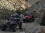
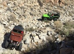
Off-road to Devil's Cove, Nevada
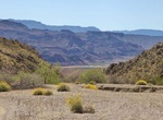
Devil’s Cove Road travels through Gold Butte National Monument to deliver you to Devil’s Cove just off the Colorado River. Much of the road provides 2WD, high-clearance vehicle access, but 4WD is required to do the full drive and reach the cove. This area is wild and remote, so you won’t find any restrooms, water or gas. Cell service is also bad to n... -
Visit Devil's Golf Course, Death Valley National Park
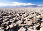
The Devil's Golf Course is a large salt pan on the floor of Death Valley, located in the Mojave Desert within Death Valley National Park. The park is in eastern California. It was named after a line in the 1934 National Park Service guide book to Death Valley National Monument, which stated that "Only the devil could play golf" on its surface, due to a rough texture f... -
Off-road Devils Lane, Canyonlands National Park, Utah
Devils Lane goes from Elephant Hill Loop at mile 4.1 to Confluence Overlook Trail in Canyonlands National Park. At mile 3 is a short spur road to the east to the Joint Trail. Continuing beyond this junction goes into a much narrower graben with pinnacles rising hundreds of feet overhead. -
Off-road to Devil's Nostril (Mud Wash N Rd), Gold Butte National Monument, Nevada
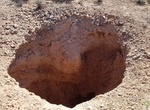
Devils Nostril is small sinkhole out in the middle of nowwhere in Gold Butte National Monument. It's like a small version of Devil's Throat. This one was also caused by the roof of a limestone cave collaspsing. -
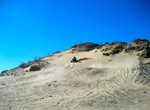
ATV Devil's Slide, Ocotillo Wells SVRA, California
Devil's Slide is a 200 foot-high granite and sand island in Ocotillo Wells Recreation Area named for the challenge it presents to the OHV enthusiast. It is actually an ancient decomposing mountaintop. A dark coat of desert varnish covers the rocks as a result of exposure to sunlight. There are several old hidden mine shafts along the mountainside. The mines are said t... -
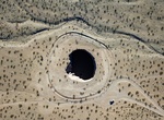
Off-road to Devils Throat, Gold Butte National Monument, Nevada
Devils Throat is a sinkhole in the middle of the open desert in Gold Butte National Monument, Nevada. It has chain-link fence that surrounds the sink hole. From The Cistern (Whitney Pockets), drive south on Gold Butte Road for 7.25 miles to a signed turnoff to Devils Throat and the Red Bluff Byway. -
Off-road to Dexter #7 Mine at Calf Mesa, San Rafael Swell, Utah
The old Dexter 7 mine is near the south end of Calf Mesa in the northern part of the San Rafael Swell. From 1950 through 1957 the mine produced more than 500 tons of ore which averaged about 0.20 percent U308 and 0.05 percent V205.
Price: $289.36