Give us feedback!


 See all

Our philosophy is simple. We want to encourage you to dream. BIG! Then we help you plan your trip, get the most out of it while you're traveling and help you share your experience with friends.
Join Now It's FREE
Dream Packages
Duration: 3 hours
Price: $120.56
Price: $120.56
Duration: 10 hours
Price: $270.00
Price: $270.00
Duration: 6 hours
Price: $499.00
Price: $499.00
Duration: 12 hours
Price: $211.46
Price: $211.46
Dreams Still To Do
Checked-Off Dreams
Dreams Still To Do
Checked-Off Dreams
Advertisement
Explore Driving Experiences
-
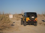
Off-road to Diablo Drop-Off (Arroyo Seco Del Diablo), Anza-Borrego Desert State Park, California
Arroyo Seco Del Diablo is a trail through Anza-Borrego Desert State Park to get from S2 to Fish Creek via Vallecito Creek Road. High clearance 4WD required. There are two very narrow sections and many areas requiring high clearance. The Diablo Drop-off section of the trail is ONE-WAY going south-to-north. There are a few primative campsite along the road that are... -
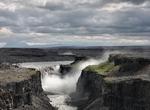
Drive Diamond Circle, Iceland
The Diamond Circle is a popular tourist route around Húsavík and Lake Mývatn in North Iceland. The four primary stops on the route are The town of Húsavík, Ásbyrgi Canyon, Lake Mývatn and Dettifoss Waterfall, the most powerful waterfall in Europe. Other stops include Vatnajökull National Park, Goðafoss Waterfal... -
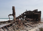
Drive Diamond Coast Shipwreck 4x4 Trail, South Africa
The Shipwreck 4x4 Trail is a one-way drive along sandy, under-used roadways between Koingnaas and Kleinzee on the north-west part of South Africa's Diamond Coast. The trail links three major wrecks – the Piratiny, Border and Arosa. The coastline, much of which is owned by De Beers, remains largely unchartered territory thanks to former diamond mining in the are... -
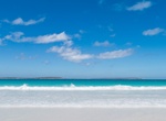
Off-road to Dillon Beach, Bremer Bay, Western Australia
Dillon Beach is quite long and stretches across the western half of Dillon Bay. -
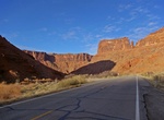
Drive Dinosaur Diamond Scenic Byway, Utah & Colorado
The Dinosaur Diamond Scenic Byway is a 512-mileNational Scenic Byway in the U.S. states of Utah and Colorado. The highway forms a diamond-shaped loop with vertices at Moab, Helper, Vernal and Grand Junction. The segment within Utah is known as the Dinosaur Diamond Prehistoric Highway. The segment within Colorado is known as the Dinosaur Diamond Scenic and Historic Byw... -
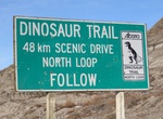
Drive Dinosaur Trail, Alberta, Canada
The Dinosaur Trail is a name applied to three provincial highways in the province of Alberta, Canada, paralleling the Red Deer River on both sides, from Drumheller to the Bleriot Ferry. This 48 KM circular driving route start and end in the town of Drumheller. The trail includes the Tyrrell Museum, and amazing badlands scenery. Stop at the Horshoe Canyon Lookout and... -
Off-road Doll House Road, The Maze, Canyonland National Park, Utah
Doll House Road is accessed from Flint Trail in The Maze, Canyonland National Park. The Flint Trail is often closed during winter. The road between Teapot Rock campsite and the Land of Standing Rocks is considered very difficult under any conditions and involves considerable risk of vehicle damage. Four-wheel-drive roads in The Maze are extremely remote, very difficu... -
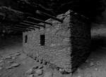
Off-road & Hike to Doll House Ruins, Bears Ears National Monument, Utah
The 800 year old Doll House is located in the Bears Ears National Monument west of Blanding, Utah. It located on a branch of Wooden Shoe Canyon, on the edge of the Dark Canyon Wilderness Area. Constructed by Ancient Pueblan indians around 1260 AD. There are still corn cobs from the original residents in the ruin. Doll House Ruin requires a long drive on dirt roads an... -
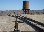
Off-road to Dolly Varden Mine, Mojave National Preserve, California
Dolly Varden Mine is an adandoned mine southwest of Cima in Mojave National Preserve. Take Kelso Cima Road to just north of Cima and turn east on Cina Road. Drive 2.7 miles on the dirt road to the mine. -
Off-road or Hike to Dolomite Mine Ruins & Peak, Anza Borrego, California
The Dolomite Mine Ruins are located in Anza Borrego State Park and date back to the 1930s. The peak above the Mine is one of the easiest peaks in the park and considered moderate with some small boulders to enjoy a short scramble across the rock strewn ridge to the rounded summit. The elevation is 1850 feet. There is an impressive overlook across the Carrizo Badlands... -
Off-road Dome Plateau ATV Trail, Utah
Off-road the Dome Plateau ATV Trail to the end for a great view from the cliffs 1,700 feet above the Colorado River Canyon. Dome Plateau is a large highland area north of the Colorado River and east of Arches National Park. This trail offers dramatic arches, several overlooks, cathedral-size caves and an old mining camp with cabins. A great trail for ATVs and UTVs. -
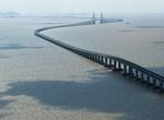
Drive across Donghai Bridge, China
Donghai Bridge ("East Sea Grand Bridge") is one of the longest cross-sea bridges in the world. It was completed on December 10, 2005. It has a total length of 32.5 kilometres (20.2 mi) and connects mainland Shanghai and the offshore Yangshan deep-water port in China. Most of the bridge is a low-level viaduct. There are also cable-stayed sections to allow for the passa... -
Drive Donohue Highway, Queensland, Australia
The Donohue Highway is a 249 km (155 mi) mostly unpaved outback track that leads through the northern foothills of the Simpson Desert in Queensland to Tobermorey Homestead, Northern Territory near the Northern Territory/Queensland border in Australia. The road branches from the Diamantina Developmental Road 7 km (4 mi) north-west of Boulia and proceeds towards the Nor... -
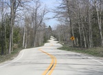
Drive Door County Curvy Highway (WI-42), Ellison Bay, Wisconsin
Near the northern terminus of Wisconsin Highway 42 is a section known as the Door County Curvy Highway. This unusually twisty stretch of Highway 42 was built in the early 1930s. Why was it built this way? It's probably a mix of a local landscape architect Jens Jensen who did not like stright lines - that locals have even nicknamed it “Jensen’s Road” ... -
Off-road Dos Cabezas Road, Anza-Borrego Desert State Park, California
Dos Cabezas Road in Anza-Borrego Desert State Park starts at the Imperial Highway (S2), 4 miles northwest of Ocotillo. It follows the Bajada along the base of the Jacumba Mountains. It continues along the wide sandy trail between the Jacumba and Coyote Mountains. In spring the valley is covered with orange ocotillos in full bloom, making this a pleasant sight. Part o...

Price: $551.14