Give us feedback!


 See all

Our philosophy is simple. We want to encourage you to dream. BIG! Then we help you plan your trip, get the most out of it while you're traveling and help you share your experience with friends.
Join Now It's FREE
Dream Packages
Duration: 4 days
Price: $1457.59
Price: $1457.59
Duration: 4 hours
Price: $135.27
Price: $135.27
Duration: 10 hours
Price: $270.00
Price: $270.00
Duration: 6 hours
Price: $162.00
Price: $162.00
Dreams Still To Do
Checked-Off Dreams
Dreams Still To Do
Checked-Off Dreams
Advertisement
Explore Driving Experiences
-
Drive Echo Park Road, Dinosaur National Monument, Colorado & Utah
The turnoff for Echo Park Road is located on Harpers Corner Drive, 25 miles (40 km) from Highway 40. The 13-mile (21-km), unpaved Echo Park Road is steep, with hairpin turns for the first several miles. The road ends at Echo Park which has a campground, boat launch, and hiking trails. Echo Park Road is impassable when wet. -
Drive Egmont Road, Egmont National Park, New Zealand
Egmont Road is one of three entry points to Egmont National Park. The other two being Manaia Road and Pembroke Road. -
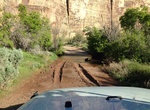
Off-road Elbow Canyon (BLM 1299) & Black Rock Road (BLM 1004), Grand Canyon-Parashant National Monument, Arizona
Black Rock Road (BLM 1004) is a point-to-point 6-mile trail in Arizona. The trail connects Black Rock Mountain Road (BLM 1022) and Black Mountain Gulch Road (BLM 1009). This trail may be closed during winter months. 4WD may be required. -
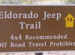
Off-road or Mountain Bike Eldorado Jeep Trail, Arizona
The Eldorado Jeep Trail Road is 13 miles of backcountry trail located in Arizona. It follows washes west from U.S. 93, running through the Black Mountains to the shore of Lake Mohave. The road is mostly smooth and flat (although the word “Jeep” in the name implies otherwise) with a just a few rocky areas. This road is a good 25 miles south of Hoover Dam an... -
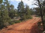
Off-road to Elephant Cove, Utah
The Elephant Cove Staging Area provides a parking and staging location for ATV/UTV enthusiasts interested in exploring the fantastic red-rock scenery and four-wheel-drive roads that make up the western side of the BLM Kanab Field Office. Amenities include a vault toilet, informational kiosk, picnic tables, fire pits, and a large, graveled parking lot. No other amenit... -
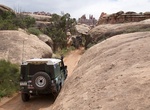
Off-road or Mountain Bike Elephant Hill Road, Canyonlands National Park, Utah
One of the most technical four-wheel-drive roads in Utah, Elephant Hill presents drivers and mountain bikers with steep grades, loose rock, stair-step drops, tight turns and tricky backing. Once over the hill, equally challenging roads lead to various features as well as BLM lands south of the park. No water is available at the campsites, but vault toilets are provide... -
Off-road El Mirage Dry Lake, California
El Mirage Lake is a dry lake bed in the Mojave Desert of San Bernardino County, California. The lake is located about 9 miles (14 km) west-northwest of the town of Adelanto and 10 mi (16 km) north of Highway 18 in San Bernardino County. The dry lake, at an elevation of 2,840 ft (870 m), is approximately 6 mi (9.7 km) long. Formerly open to all visitors, it has been a ... -
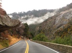
Drive El Portal Road (Highway 140), Yosemite Valley, California
NOTE: Due to a landslide, California State Route 140 will remained fully closed between Briceburg to the Yosemite Cedar Lodge and there is no estimated time when it will reopen. Drivers should avoid this route and seek alternative highways (SR-41, SR-120) to and from Yosemite National Park. The El Portal Road (Highway 140) into Yosemite Valley is only about 12 miles i... -
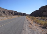
Drive Emigrant Canyon Road, Death Valley National Park, California
Emigrant Canyon Road is a 21.5 mile paved road in Death Valley National Park. The road provides access to Skidoo, Aguereberry Point, and Wildrose roads. Highway 178 (east) Watch for potholes in pavement. Subject to flooding in heavy rains. RVs, trailers, and buses over 25 ft. not allowed due to narrow canyon and roadway. -
Explore Emma Peak, Nevada
Emma Peak is located in the Flowery Range in Northwest Nevada. It is the highest point on the Flowery Ridge, a 5-mile long ridge east of Virginia City. Emma Peak is actually on the south side of Six Mile Canyon Road, and follow a parallel ridge heading east. -
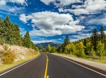
Drive Enchanted Circle Scenic Byway, New Mexico
The Enchanted Circle Scenic Byway is a New Mexico Scenic Byway and National Forest Scenic Byway located in Northern New Mexico. It begins and ends in Taos, New Mexico. The 84-mile (135 km) Enchanted Circle Scenic Byway makes a loop through Taos following four main highways: U.S. Route 64 between Eagle Nest and Taos NM 522 between Taos and Questa NM 38 between Questa,... -
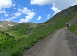
Off-road Engineer Pass Road, Colorado
This trail, combined with Cinnamon Pass, constitutes the famous Alpine Loop. Engineer Pass Road is a 20.5 mile point-to-point trail located near Ouray, Colorado. There are many waterfalls, mines and points of historical interest along the route. 4x4 high clearance vehicle is almost always required to do this road. -
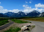
Drive Entrance Parkway, Waterton Lakes National Park, Alberta, Canada
The Entrance Parkway is an 8 km route from the Maskinonge wetlands, past the park gate to the Waterton Lakes townsite and provides scenic views overlooking the Waterton Valley. It starts out on the prairie and follows the Waterton Lakes chain past the Prince of Wales Hotel National Historic Site to the townsite. It is one of the best roads in the park for viewing wild... -
Off-road Escalante Creek Rd (650 Rd), Dominguez-Escalante National Conservation Area, Colorado
The 650 Road along Escalante Creek in Dominguez-Escalante National Conservation Area passes several landmarks. -
Hike or Ride Espinosa Trail, San Diego, California
Espinosa Trail is in Cleveland National Forest and a portion of the trail is located in the Pine Creek Wilderness. The eastern end of the trail is non-wilderness and goes through chaparral. Best time to visit is Winter and Spring. The western end of trail is mostly through oak woodland and riparian. The eastern end is mostly through chaparral. Espinosa crosses Pine Va...


Price: $312.25