Give us feedback!


 See all

Our philosophy is simple. We want to encourage you to dream. BIG! Then we help you plan your trip, get the most out of it while you're traveling and help you share your experience with friends.
Join Now It's FREE
Dream Packages
Duration: 10 hours
Price: $180.27
Price: $180.27
Duration: 6 hours
Price: $499.00
Price: $499.00
Duration: 12 hours
Price: $154.81
Price: $154.81
Duration: 8 hours
Price: $133.44
Price: $133.44
Dreams Still To Do
Checked-Off Dreams
Dreams Still To Do
Checked-Off Dreams
Advertisement
Explore Driving Experiences
-
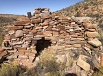
Off-road & Hike to Fort Garrett (BLM 1681), Grand Canyon-Parashant National Monument, Arizona
BLM 1681 is the thr trail below Snap Point and accessible from BLM 1012. Recommended for UTVs only. Rough and seldom traveled. The road is closed at the Grand Canyon National Park boundary to motorized vehicles. Foot traffic only to the Fort Garrett site. -
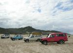
Off-road Fort Sage OHV, California
The Fort Sage Off-Highway Vehicle Area is located in the high desert region of northeastern California outside the town of Doyle. The area is about 45 miles south of Susanville, California and 45 miles north of Reno, Nevada. The special Recreation Management Area consists of approximately 28,598 acres of public land that is managed for off-highway vehicle use such as ... -
Off-road & Hike Fossil Canyon, Coyote Mountains Wilderness, California
Fossil Canyon is rocky and high walled, starting out narrow but widens considerably further up. Start at Sheep Canyon Rd from S2 and turn right up the canyon road to the barrier. The dirt road is good, but you need a bit of ground clearance. -
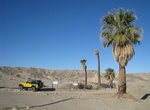
Off-road to Four Palms Oasis, Anza Borrego, California
Four Palms Oasis is located in the Truckhaven area in Anza Borrego. -
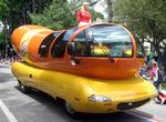
Drive or ride in Frankmobile (Wienermobile)
A "Wienermobile" (Frankmobile) is an automobile shaped like a hot dog on a bun that is used to promote and advertise Oscar Mayer products. It was created in 1936 by Oscar's nephew, Carl G. Mayer, and variants are still used by Oscar Mayer today. Drivers of the Wienermobiles are known as Hotdoggers and often hand out toy whistles shaped as replicas of the Wienermobile,... -
4WD around Fraser Island, Queensland, Australia
One of the most enjoyable ways to visit Fraser Island is by 4WD. To visit most of the main sites you should allow three days. You can hire vehicles with camping gear or stay in accommodation on the island. Fraser Magic 4WD Hire - Family run business, with a Swiss-Australian background. Provides 4wd hire from 2 up to 8 seater landrovers. Accommodation or camping packa... -
Drive & Hike Freita Route (Arouca Geopark), Portugal
The Freita Route in Portugal's Arouca Geopark crosses one of the most beautiful areas of the park. This route will guide you in a trip of almost 22 km by motor vehicle and 3.5 km by foot. Along the “Enchanted Mountain”, you can visit 11 geosites, nine of them situated in the Freita Mountain’s plateau. G1: Detrelo da Malhada Panoramic G3: S. Pedro... -
Drive Fundy Coastal Drive, New Brunswick, Canada
The 391 km (243 mi.) Fundy Coastal Drive along the Bay of Fundy, home to the world's highest tides, along the dramatic coastal between St. Stephen and Sackville. Watch for whales breaching off the coast, discover fossil-filled mudflats and play on coastal islands. -
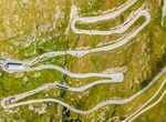
Drive over Furka Pass, Switzerland
Furka Pass (el. 2429 m.) is a high mountain pass in the Swiss Alps connecting Gletsch, Valais with Realp, Uri. The Furka Pass was used as a location in the James Bond film Goldfinger. -
Off-road Galena Canyon Road, Death Valley National Park, California
Galena Canyon Road is loctaed off West Side Road in Death Valley National Park, California. Several old mines are along the canyon. The mines on the left (south) side of the road are Bonny Mine and Mammoth Mine, while the mines on the right (north) side is the Mongolian Mine. Will need 4WD to get to the mines. NOTE: Pfizer, Inc. still owns and (sometimes) operates the... -
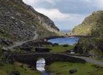
Drive or Cycle Gap of Dunloe, Ireland
The Gap of Dunloe is a narrow mountain pass between Macgillycuddy's Reeks (west) and Purple Mountain (east) in County Kerry, Ireland. It is about 11 km (6.8 mi) from north to south. Within it are five lakes: Coosaun Lough, Black Lake, Cushnavally Lake, Auger Lake, and Black Lough (north to south). These lakes are connected by the River Loe. Between the first two lakes... -
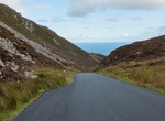
Drive Gap of Mamore, Ireland
The Gap of Mamoreis a twisting narrow road (about 2 km) over a hilltop route in the Urris Hills. For a long time the narrow road has been the only connection between Urris and Buncrana. Near the summit of Mamore Gap a number of holy relics can be found. -
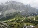
Drive over Gardena Pass, Italy
Gardena Pass is a high mountain pass in the Dolomites of the South Tyrol in northeast Italy. At an elevation of 2,136 m (7,008 ft) above sea level, the pass connects Sëlva in the Val Gardena on the west side with Corvara in the Val Badia. The road over it comprises part of the famous Sella Ring, in which four linked passes (Gardena, Sella, Pordoi, and Campolongo)... -
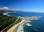
Drive Garden Route Biosphere Reserve, South Africa (UNESCO Site)
The Garden Route is a popular stretch of the south-eastern coast of South Africa. It stretches from Heidelberg in the Western Cape to the Storms River which is crossed along the N2 coastal highway over the Paul Sauer Bridge in the extreme western reach of the neighbouring Eastern Cape. The name comes from the verdant and ecologically diverse vegetation encountered her... -
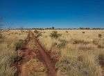
Off-road Gary Highway, Western Australia
The Gary Highway is a remote unsealed track in central Western Australia running through the Gibson Desert and the Great Sandy Desert. It was built by Len Beadell's Gunbarrel Road Construction Party in April and May 1963 and named after Beadell's son who was born in February that year. It connects the Gunbarrel Highway from Everard Junction in the south, to the Gary J...

Price: $312.25