Give us feedback!


 See all

Our philosophy is simple. We want to encourage you to dream. BIG! Then we help you plan your trip, get the most out of it while you're traveling and help you share your experience with friends.
Join Now It's FREE
Dream Packages
Duration: 8 hours
Price: $108.64
Price: $108.64
Duration: 4 days
Price: $772.57
Price: $772.57
Duration: 10 hours 30 minutes
Price: $129.01
Price: $129.01
Duration: 6 hours
Price: $162.00
Price: $162.00
Dreams Still To Do
Checked-Off Dreams
Dreams Still To Do
Checked-Off Dreams
Advertisement
Explore Driving Experiences
-
Off-road to Five 'Corners' of Australia
Visiting all five border corners of Australia isn't so straight forward but can be a fun adventure. The 5 corners are: Poeppel Corner Cameron Corner Haddon Corner MacCabe Corner Surveyor Generals Corner New Year's Eve occurs three times each year at thirty minute intervals in Poeppel Corner (also in Cameron Corner and Surveyor Generals Corner), because it is... -
Drive Fjallabaksleið Nyrðri (F208), Iceland
Fjallabaksleið nyrðri (F 208) is dirt road in the Iceland Highlands that runs between Búland and Sigalda. It turns back into 208 when passing F224 close to Landmannalaugar. It's 112 km (69.6 miles) and takes around 3 1/4 hours. -
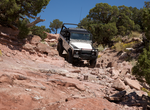
Off-road Flat Iron Mesa Safari Trail, Moab, Utah
The Flat Iron Mesa Safari Trail is popular during the Easter Jeep Safari but is lightly used the rest of the year. Route-finding is challenging because tire tracks can be hard to find. Flat Iron Mesa is south of Moab and is bounded by Kane Springs Canyon on the north, Hatch Wash Canyon on the west, West Coyote Canyon on the south, and Highway 191 on the east. The 4WD ... -
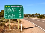
Drive Flinders Highway (B100), South Australia
Flinders Highway connects the South Australian towns of Ceduna and Port Lincoln, a distance of 410 kilometres. The highway was formerly designated as National Route Alternate 1 and currently signed as B100. Route B100, formerly National Route Alternate 1 (from 1978 to 1999), consisting of the Flinders Highway and Lincoln Highway, presents an alternative but somewhat l... -
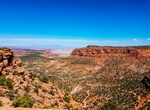
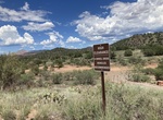
Off-road Flint Trail to The Maze, Canyonland National Park, Utah
The Flint Trail traverses slopes of clay that are extremely slippery when wet. The Flint Trail is often closed during winter. The road between Teapot Rock campsite and the Land of Standing Rocks is considered very difficult under any conditions and involves considerable risk of vehicle damage. Four-wheel-drive roads in The Maze are extremely remote, very difficult, p... -
Drive Floor of the Valley Road (Zion Canyon Scenic Drive), Zion National Park, Utah
The Floor of the Valley Road, also known as the Zion Canyon Scenic Drive, follows the canyon of the North Fork of the Virgin River, also known as Zion Canyon, through Zion National Park, Utah, USA. A precursor to the present nine-mile road was first built in 1916, but was later redesigned by the National Park Service Branch of Plans and Designs to highlight the natura... -
Drive to Fontainhas, Santo Antão, Cape Verde
Fontainhas is a settlement in the northern part of the island of Santo Antão, Cape Verde. It is situated near the rocky north coast of the island, 2 km southwest of Ponta do Sol and 19 km north of the island capital Porto Novo. The settlement includes the smaller villages Corvo and Forminguinhas, about 1 km west of Fontainhas proper. -
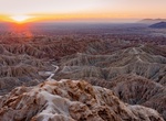
Drive or Hike to Fonts Point, Anza-Borrego Desert State Park, California
Fonts Point Trail is a popular trail in Anza-Borrego Desert State Park, California. The trail is mostly soft sand for the whole way. It's possible to drive a passenger vehicle but it's risky. That trail starts at S-22 at the Fonts Point Wash. Once parked walk up a little to get some great views of the Borrego Badlands. Another great view is from nearby Inspiration Poi... -
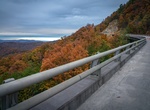
Drive Foothills Parkway, Great Smoky Mountains National Park
The Foothills Parkway is a national parkway which partly traverses the foothills of the northern Great Smoky Mountains in East Tennessee, located in the southeastern United States. If completed, the 71-mile (114 km) parkway will connect U.S. Route 129 (U.S. 129) along the Little Tennessee River in the west with Interstate 40 (I-40) along the Pigeon River in the east. ... -
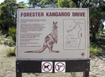
Drive Forester Kangaroo Drive, Mount William National Park, Tasmania, Australia
Forester Kangaroo Drive is an unsealed dirt road that connects to Musselroe Bay Road at both ends. At dawn and dusk kangaroos and wallabies come out in droves to graze in the fields. Forester Kangaroos are the only kangaroos in Tasmania, and this is one of the best places to see them. -
Off-road Forest Road 525, Sedona, Arizona
Forest Road 525C is part of the scenic loop that runs north of Arizona Route 89A. In 2020 locals raise alarm on overcamping along 525. Coconino National Forest has changed dispersed camping in the Sedona and Flagstaff Arizona areas for 2022. Campers and recreationists visiting Coconino National Forest in the area of Forest Road 525 will be able to use and camp in eig... -
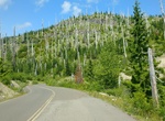
Drive Forest Road 99, Washington
This 16-mile, winding road leads you from forests into the heart of the blast zone. Ten interpretive sites provide views of the volcano and interpretive information. The final site, Windy Ridge Viewpoint, offers a sweeping vista of the crater, Spirit Lake and landscape blasted by the 1980 eruption. This drive is extremely popular, so expect visitors. The road is diff... -
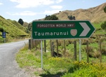
Drive Forgotten World Highway, New Zealand
New Zealand State Highway 43 (SH 43), also called the Forgotten World Highway, is a road that runs 148 km from Stratford in Taranaki to Taumarunui in the King Country. It contains the only unsealed portion of the New Zealand state highway network. The road passes through small towns such as Toko, Douglas, Te Wera, Pohukura, Strathmore, Whangamōmona, Marco, Koruatahi, ... -
Drive Formula One Car
Formula One, also known as Formula 1 or F1 and referred to officially as the FIA Formula One World Championship, is the highest class of single seater auto racing sanctioned by the Fédération Internationale de l'Automobile (FIA). The "formula" designation in the name refers to a set of rules with which all participants' cars must comply. The F1 season co... -
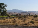
Drive Fort Churchill and Sand Springs Toll Road, Nevada
Fort Churchill and Sand Springs Toll Road was opened in 1866. A segment of the toll road within Churchill County, Nevada is listed on the National Register of Historic Places on November 24, 1974. This segment allowed a team of 18 mules to pull three heavily laden freight wagons across a mountain. One end of the road was located at Fort Churchill. Running between Dayt...


Price: $211.46