Give us feedback!


 See all

Our philosophy is simple. We want to encourage you to dream. BIG! Then we help you plan your trip, get the most out of it while you're traveling and help you share your experience with friends.
Join Now It's FREE
Dream Packages
Duration: 4 hours
Price: $135.27
Price: $135.27
Duration: 3 hours
Price: $120.56
Price: $120.56
Duration: 14 hours
Price: $551.14
Price: $551.14
Duration: 10 hours 30 minutes
Price: $129.01
Price: $129.01
Dreams Still To Do
Checked-Off Dreams
Dreams Still To Do
Checked-Off Dreams
Advertisement
Explore Driving Experiences
-
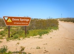
Off-road Dove Springs OHV Area, California
From cross-country play in the sandy bowl to steep hill climbs, the Dove Springs OHV area offers over 5,000 acres of open-use public land for you to enjoy. The Dove Springs bowl is also a great starting point to begin to explore the hundreds of miles of trail riding opportunities available in this region. -
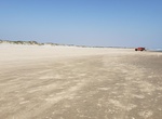
Drive Down Island (South Beach), Padre Island National Seashore, Texas
One of the most popular activities to do when visiting the national seashore is to drive on the beach and travel down island. Venturing beyond the pavement can get you to some of the most remote areas of the park, awarding you the experience of solitude in this natural landscape. Popular areas of the park such as Little Shell Beach, Big Shell Beach, Yarborough Pass, a... -
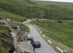
Drive Drumbeg Road (B869), Sutherland, Scotland
Drumbeg Road (B869) is a 35.4km (22 miles) long drive through the Assynt district of Sutherland in the Scotish Highlands. This picturesque route has stunning views of beaches, lochs, mountains and the sea. It's a paved road but very narrow and has steep hills and unexpected switchbacks. -
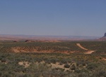
Off-road Dry Fork - Coyote Gulch (Hole-in-the-Rock Road), Utah
To reach Dry Fork - Coyote Gulch drive from the town of Escalante, Utah for 5.0 miles east on Highway 12 to the signed Hole-In-The-Rock Roa. For here there is a good gravel road on the south side of Highway 12 that leads to the Hole-In-The-Rock Road. From here travel 26.3 miles to the signed Dry Fork Road. Turn east (left) and follow the Dry Forks Road 0.7 miles to ... -
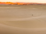
Off-road or Sandboard Dumont Dunes OHV Area, California
Dumont Dunes is an area of the Mojave Desert containing large sand dunes, located approximately 31 miles north of Baker, California on California State Route 127. The Dumont Dunes Off -Highway Vehicle (OHV) Area, also referred to as an Open Area, is an exciting and remote area for OHV recreation. Bordered by steep volcanic hills and the slow running Amargosa River, th... -
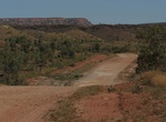
Drive Duncan Road, Western Australia & Northern Territory
Duncan Road is a generally northeast-southwest former highway in the northeast of Western Australia and northwest of Northern Territory which links the Victoria Highway with Halls Creek. The road, approximately 443 kilometres (275 mi) in length, was designated as National Route 80 from its terminus at Halls Creek through to Nicholson. National Route 80 continued east ... -
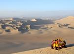
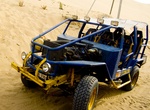
Ride Dune Buggy
A dune buggy is a recreational vehicle with large wheels, and wide tires, designed for use on sand dunes, beaches, or desert recreation. It is called a "Beach Buggy" in the United Kingdom, Ireland and many other English speaking countries. The design is usually a modified vehicle and engine mounted on an open chassis. The modifications usually attempt to increase the ... -
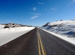
Drive Dunes Drive, White Sands National Monument, New Mexico
Dunes Drive is an eight-mile (13 km) scenic drive that leads from the visitor center into the heart of the gypsum dunefield. The 16-mile (26km) round-trip drive takes approximately 45 minutes. However, you may want to allow additional time to explore the dunes, take photos, and/or learn about the natural and cultural history of the world's largest gypsum dunefield. Al... -
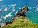
See Views from Dunquin, County Kerry, Ireland
Dún Chaoin is a Gaeltacht village in west County Kerry, Ireland. Dunquin lies at the Western tip of the Dingle Peninsula, overlooking the Blasket Islands. It is the most westerly settlement of Ireland. Nearby Dunmore Head is the most westerly point of mainland Ireland. There is dramatic cliff scenery, with a view of the Blasket Islands, where Peig Sayers lived.... -
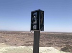
Off-road to Dusty Phone Booth & Basketball Hoop, Ocotillo Wells SVRA, California
This steep hill is often used as a navigation point by those exploring the Truckhaven region. The peak of this unique hill is topped with a novelty phone booth. Nearby, one can find some intriguing pieces of “off-road folk art” including totem poles and a concrete motorcycle. -
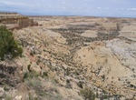
Off-road Eagle Canyon Road, San Rafael Swell, Utah
Eagle Canyon Road is an old Jeep trail in southern San Rafael Swell area of Utah. The canyon is open to high clearance 4x4 vehicles but if they are much wider than a jeep they might not be able to make it around a few of the obstacles where the road is either washing out or partially obstructed by rock falls. The trailhead is right at the Swasey Cabin site where a res... -
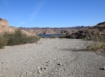
Drive Eagle Wash Road, Nevada
Eagle Wash Road is a great run for those looking for a short, easy drive with scenic views of the surrounding desert and mountains. The road ends at a cove on the Colorado River. This is a great place for swimming or other water activities during the summer. Eagle Wash Road is connected to several trails that can be explored at the same time. TIPS: 4WD recommended... -
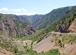
Drive East Portal Road, Gunnison National Park, Colorado
Those wishing to drive to the Gunnison River may do so by taking the East Portal Road. This road provides access into Curecanti National Recreation Area where camping, picnicking and fishing are available. East Portal Road is closed in winter. The road has very steep grades and hairpin curves. Vehicles with an overall length (including trailer) greater than 22 feet ar... -
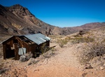
Off-road Echo Canyon to Inyo Mine, Death Valley National Park, California
Echo Canyon Road is a very fun off-road drive in the Death Valley National Park and is 10 miles to Inyo Mine Start. A high-clearance vehicle is needed for the first 3 miles and then 4x4 is required. The road tends to have deep gravel and is quite rocky 3 miles from the highway. High-clearance first three miles, 4WD required beyond. Lees Camp Road, which connects to Am...
Price: $108.64