Give us feedback!


 See all

Our philosophy is simple. We want to encourage you to dream. BIG! Then we help you plan your trip, get the most out of it while you're traveling and help you share your experience with friends.
Join Now It's FREE
Dream Packages
Duration: 14 hours
Price: $551.14
Price: $551.14
Duration: 12 hours
Price: $211.46
Price: $211.46
Duration: 4 days
Price: $1457.59
Price: $1457.59
Duration: 8 hours
Price: $133.44
Price: $133.44
Dreams Still To Do
Checked-Off Dreams
Dreams Still To Do
Checked-Off Dreams
Advertisement
Explore Driving Experiences
-
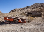
Off-road Goler Wash Road (Coyote Canyon Road), Death Valley National Park, California
Goler Wash Road goes from Wingate Rd to Barker Ranch. Also connect to Coyote Canyon Road. Distances: Start at Wingate Rd Enter Goler Canyon: 1.5 miles Newman Cabin and campsite: 3.7 miles Turnoff (South) to Keystone Mine Camp: 4.4 miles Turnoff (South) to Baker Ranch & Start of Coyote Canyon Road: 5.8 miles Barker rnach: 6.4 miles For experienced 4WD drivers onl... -
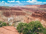
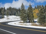
Drive to Goosenecks & Panorama Point Overlooks, Capitol Reef National Park, Utah
Goosenecks Overlook is located in the northern part of Capitol Reef National Park along route 24, just south of Chimney Rock Trail. The 800ft-high viewpoints above Sulphur Creek are worth a stop. Afternoon light is best for photography. On the road up to Goosenecks, stop at Panorama Point Overview. A deep, colorful canyon has been cut by Utah's Sulphur Creek as s... -
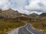
Drive Gordon River Road (Strathgordon Road (B61)), Tasmania, Australia
The Gordon River Road, sometimes called the Strathgordon Road, (B61), is a road in the south western region of Tasmania, Australia. The 85-kilometre (53 mi) road was built by the Hydro-Electric Commission of Tasmania with funding from the Australian Government to service the construction of the Gordon and the Serpentine dams, leading to the flooding of Lake Pedder. In... -
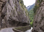
Drive Gorges de Saint-Georges, France
Gorges de Saint-Georges goes alongside Aude river and is so narrow that there is only one lane for the road. There is a traffic light to regulates safe driving through this spectacular street. The gorge is located near the town of Axat in Aude department, southern France. -
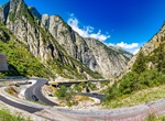
Drive Gotthard Pass, Switzerland
The Gotthard Pass or St. Gotthard Pass (Italian:Passo del San Gottardo, German:Gotthardpass) at 2,106 m (6,909 ft) is a mountain pass in the Alps traversing the Saint-Gotthard Massif and connecting northern and southern Switzerland. The pass lies between Airolo in the Italian-speaking canton of Ticino, and Andermatt in the German-speaking canton of Uri, and connects f... -
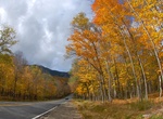
Drive through Grafton Notch, Maine
Grafton Notch is a notch, or mountain pass, located in Oxford County, Maine. The notch demarks the northeastern end the Mahoosuc Range, and thus of the White Mountains. Maine State Route 26 passes through the notch. North of the height of land, the notch drains into the Swift Cambridge River, then into the Dead Cambridge River and Umbagog Lake, the source of the Andro... -
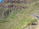
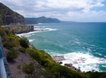
Drive Gran Canaria West Coast Road (GC-200), Gran Canaria, Canary Islands
Most of the west coast of Gran Canaria are high cliffs. Carved in these cliffs, several hundred metres above the ocean, is road GC-200, an exhilarating drive and one of the most exciting drives in the Canary Islands. The best section (between the viewpoints Mirador del Balcon and Andén Verde) has been closed since 2016 following major rock falls. There is now a... -
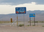
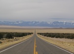
Drive Grand Army of the Republic Highway (Nevada Route 6), Nevada
U.S. Route 6 (US 6) stretching from Bishop, California, in the west to Provincetown, Massachusetts, on the East Coast. Named the “Grand Army of the Republic” highway in honor of the Union Army during the Civil War, was one of the earliest coast-to-coast numbered routes. The Nevada portion crosses the center of the state, serving the cities of Tonopah and E... -
Drive Grand Army of the Republic Highway (Utah Route 6), Utah
U.S. Route 6, also known as the Grand Army of the Republic Highway, runs through Rocky River as Lake Road. This route goes from just west of Green River to the Nevada border. The Grand Army of the Republic was an organization of veterans of the Civil War. The organization ended when the last Civil War veteran died in 1956. -
Off-road Grand Bench Road, Grand Staircase-Escalate National Park, Utah
Grand Bench Road in Grand Staircase-Escalate National Park is rough and not driven often. There also is a huge gorge you have to drive down into and out of. Expect it to take about 7 hours to go 40 miles. Not recommend after a rain. -
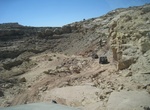
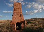
Off-road to Grand Gulch Mine (BLM 1002), Grand Canyon-Parashant National Monument, Arizona
Grand Gulch Mine was a very profitable copper mine in the Arizona strip, located along BLM 1002 road in Grand Canyon-Parashant National Monument in Arizona. Because the mine was a wealthier mine, the buildings are still in relatively good shape, so it’s worth the trip to check out. This drive can be a long one, so plan for the whole day and bring plenty of food ... -
Drive & Cycle Grand Loop Road, Yellowstone National Park
The Grand Loop Road Historic District encompasses the primary road system in Yellowstone National Park. Much of the 140-mile (230 km) system was originally planned by Captain Hiram M. Chittenden of the US Army Corps of Engineers in the early days of the park, when it was under military administration. The Grand Loop Road provides access to the major features of t... -
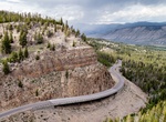
Drive Grand Mesa Scenic and Historic Byway, Colorado
Grand Mesa Scenic and Historic Byway, also known at the Grand Mesa National Scenic and Historic Byway, runs North from Cedaredge along Highway 65, to the top of the Grand Mesa at more than 10,000 feet (3,000 m). It also includes Land's End Road to the Land's End Observatory from Highway 65. The byway sneaks past Island Lake, one of more than 300 trout-filled lakes in ... -
Drive Grand Pacific Drive, New South Wales, Australia
Starting in the Royal National Park, less than an hour south of Sydney's CBD, the Grand Pacific Drive is a 140 kilometre scenic coastal drive taking you through rainforests, over the iconic Sea Cliff Bridge and through the coastal cities and townships of Wollongong, Shellharbour, Kiama and the Shoalhaven. You can choose to make your way back to Sydney via the charmin... -
Attend Grand Prix of Long Beach, California
The Toyota Grand Prix of Long Beach is an open-wheel race held on a street circuit in Long Beach, California. Christopher Pook is the founder and promoter which began as a vision while working at a travel agency in downtown Long Beach. It was the premier circuit in the Champ Car from 1996, and was the first event in the World Series each year from 2004. The 2008 ...

Price: $270.00