Give us feedback!


 See all

Our philosophy is simple. We want to encourage you to dream. BIG! Then we help you plan your trip, get the most out of it while you're traveling and help you share your experience with friends.
Join Now It's FREE
Dream Packages
Duration: 12 hours 30 minutes
Price: $289.36
Price: $289.36
Duration: 10 hours 30 minutes
Price: $129.01
Price: $129.01
Duration: 4 hours
Price: $135.27
Price: $135.27
Duration: 3 days
Price: $559.53
Price: $559.53
Dreams Still To Do
Checked-Off Dreams
Dreams Still To Do
Checked-Off Dreams
Advertisement
Explore Driving Experiences
-
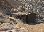
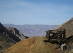
Off-road to Chloride City, Death Valley National Park, California
Chloride City is a ghost town in Inyo County, California, USA. It is located 8.5 miles (14 km) north-northeast of Beatty Junction, at an elevation of 4,770 ft (1,450 m). The former settlement is now in Death Valley National Park. The town was established in 1905 when the Bullfrog, Nevada, gold discovery brought people into the area. The ghost town contains numerous ad... -
Off-road Christmas Tree Pass Road, Nevada
This graded, dirt road runs through 16 miles of ruggedly beautiful canyon rich with wildlife and petroglyphs, so make sure to bring your camera for this one. Petroglyphs are located in Grapevine Canyon and are worth the hike to reach them. The extensive petroglyphs in Grapevine Canyon are accessible from the Christmas Tree Pass Road, located off State Highway 163, si... -
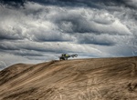
Off-road Christmas Valley Sand Dunes, Oregon
The Christmas Valley Sand Dunes are a natural sand dune complex covering 11,000 acres (45 km2) of public lands east of Christmas Valley in Lake County, Oregon, United States, about 100 miles (160 km) southeast of Bend. The area is accessible via the Christmas Valley National Back Country Byway. The dunes are up to 60 feet (18 m) high. It is the largest inland shifting... -
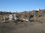
Off-road to Chuckwalla Springs Mine & Arch, Bradshaw Trail, California
Chuckwalla Springs Arch, California -
Off-road Cigarette Springs Road (Cedar Mesa), Bears Ears National Monument, Utah
Cigarette Springs Road is a fairly well-maintained but rough road that cuts deep into the heart of Cedar Mesa area of Bears Ears National Monument. Cigarette Springs Road is about 19 miles from the U.S. 163 turnoff. Road Canyon and The Citadel are the main sites to hike. -
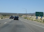
Drive Cima Road, Mojave Desert, California
Cima Road is a 15-mile long corridor from Kelso Cima Road to Ivanpah Road. It is a key link between Interstate 40 and 15, posted at 55mph with an approximate ADT of 650. The roadway width varies from 22 feet to 24 feet. The route is characterized by extremely soft shoulders, with numerous low water crossings. The proposed project includes: increasing the roadway width... -
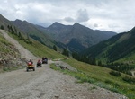
Off-road Cinnamon Pass Road, Colorado
This trail, combined with Engineer Pass, constitutes the famous Alpine Loop. Cinnamon Pass Road is a 9.2 mile out and back trail with a mslal section in a loop connection Animas Forks with American Basin. Cinnamon Pass sits 12,640’ above the San Juan Mountains. During the gold rush of Colorado, Cinnamon pass was used to reach what would soon be the town of Sil... -
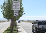
Drive on Civic Musical Road, Lancaster, California
The Civic Musical Road was built on Avenue K in Lancaster, California, United States, on 5 September 2008. Covering a quarter-mile stretch of road between 60th Street West and 70th Street West, the Musical Road used grooves cut into the asphalt to replicate part of the Finale of the William Tell Overture. It was paved over on 23 September after nearby residents compla... -
Off-road to Clair Camp, Pleasant Canyon Trail, Panamint Valley, California
Clair Camp is a popular 4×4 destination located 5 miles east of Ballarat up Pleasant Canyon. There are several early 1900s era cars and an abandoned grader with a flat tire along the trail. -
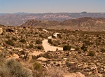
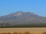
Off-road to Clark Mountain Mine Sites, Mojave National Preserve, California
Clark Mountain is a mountain located in the Clark Mountain Range in the Mojave National Preserve, close to the California-Nevada border. A network of dirt roads lead to several abandoned mine and town sites. Exit I-15 at Cima Road or Yates Well use a map to navigate a maze of unmaintained dirt roads. Clark Mountain is the only portion of Mojave National Preserve nort... -
Off-road Cleghorn Ridge Trail, California
Cleghorn Ridge Trail is a combination of two parallel trails, one difficult and the other easy that intersect at several points. Beginning at Silverwood Lake, California Hwy 138 this trial offers ridge top views over Mount Baldy and ends at I-15 Cajon Pass exit 129 or back to Hwy 138 again. The difficult trail runs from Silverwood Lake entrance to the intersection on ... -
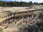
Drive Cliff Palace Loop Road, Mesa Verde National Park, Colorado
Cliff Palace Loop Road is a 6-mile (10-km) drive with overlooks of various cliff dwellings, access to the ranger-guided tours of Cliff Palace and Balcony House, and the trailhead for the Soda Canyon Overlook Trail.Stops along this road include: Cliff Palace Overlook Cliff Canyon Overlook House of Many Windows Overlook Hemenway House Overlook Balcony House Parki... -
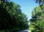
Drive Clinton Road, New Jersey
Clinton Road is located in West Milford, Passaic County, New Jersey. It runs in a generally north-south direction, beginning at Route 23 near Newfoundland and running roughly 10 miles (16 km) to its northern terminus at Upper Greenwood Lake. The road and the land around it have gained notoriety over the years as an area rife with many legends of paranormal occurrences... -
Off-road Cohenour Loop Road, Lake Mead, Arizona
Cohenour Road Loop is an off-road adventure that takes you past abandoned mines, around a volcanic peak and through some desert canyons. You might even see some wild horses or burros, and can definitely expect to see some petroglyphs. Although this trail is fairly easy, sand makes 4WD a must. Access: Cohenour Loop Road is a 4WD access road and starts along Bonelli... -
Drive or Ride Col de Turini, France
The Col de Turini (el. 1607 m) is a high mountain pass in the Alps in the department of Alpes-Maritimes in France. It lies near Sospel, between the communes of Moulinet and La Bollène-Vésubie in the Arrondissement of Nice. It is famous for a stage of the Monte Carlo Rally which is held on the tight road with its many hairpin turns. Until a few years ago,...


Price: $229.00