Give us feedback!


 See all

Our philosophy is simple. We want to encourage you to dream. BIG! Then we help you plan your trip, get the most out of it while you're traveling and help you share your experience with friends.
Join Now It's FREE
Dream Packages
Duration: 10 hours
Price: $180.27
Price: $180.27
Duration: 12 hours
Price: $154.81
Price: $154.81
Duration: 3 days
Price: $604.38
Price: $604.38
Duration: 3 hours
Price: $312.25
Price: $312.25
Dreams Still To Do
Checked-Off Dreams
Dreams Still To Do
Checked-Off Dreams
Advertisement
Explore Driving Experiences
-
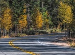
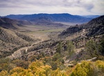
Drive California State Route 38
State Route 38 (SR 38) is a mostly rural and scenic road in the U.S. state of California. Despite the orientation of its alignment, SR 38 is assigned in a west–east direction. This route is part of the California Freeway and Expressway System and is eligible for the State Scenic Highway System. However, it is only a scenic highway between a point east of the Sou... -
Drive California State Route 49
State Route 49 (SR 49) is a north–south state highway in the U.S. state of California that passes through many historic mining communities of the 1849 California gold rush. Highway 49 is numbered after the "49ers", the waves of immigrants who swept into the area looking for gold, and it is known as the Golden Chain Highway. This roadway begins at Oakhurst, Mader... -
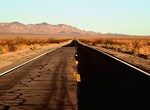
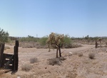
Drive California State Route 62 (29 Palms Hwy), California
State Route 62 (SR 62) is a state highway in the U.S. state of California that cuts across the Little San Bernardino Mountains in Riverside and San Bernardino counties. Its western terminus is at Interstate 10 in unincorporated Riverside County outside the borders of Whitewater and Palm Springs. Its eastern terminus is at the Arizona state line just east of Parker, Ar... -
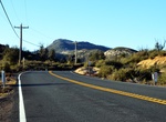
Drive California State Route 79 (SR79), San Diego County, California
State Route 79 (SR 79) is a state highway in the U.S. state of California. The route begins at Interstate 8 (I-8) in San Diego County, continuing north through the town of Cuyamaca into Julian. After passing through Warner Springs, the route crosses into Riverside County, providing access to the cities of Temecula and Murrieta. SR 79 ends at I-10 in Beaumont. SR 79 be... -
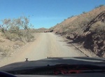
Off-road or Mountain Bike Callville Wash North Trail, Nevada
A fairly easy drive, Callville Wash North Trail gives you the thrill of driving in the wilderness without ever being more than 2 miles from the paved Northshore Road. Although in most conditions, it can probably done in a 2WD vehicle like a Jeep, 4WD is recommended for safety, as the second half of the drive gets rougher and rockier. Always check the weather report be... -
Off-road or Mountain Bike Callville Wash South Trail, Nevada
The Callville Wash South Road is a dirt road along the bed of Callville Wash, running from Northshore Road and featuring 5 miles of rugged desert landscape, including sandstone bluffs and imposing mountains. It is a fairly safe road that ends across the water from Callville Bay, but does have some sections where a 4WD is highly recommended. TIPS: Pay attention t... -
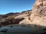
Off-road Callville Wash Trail, Lake Mead, Nevada
This is an easy off-road trail near the site of historic Fort Callville that was established as a Mormon outpost, shut down in 1869, and put underwater with the filling of Lake Mead in the 1930s. Distance: 12 miles out and back How to Get There: Calville Wash Trail is located between mile markers 13 & 14 along Northshore Drive in Lake Mead NRA TIPS: Fee ... -
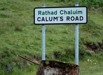
Drive Calum's Road, Isla of Raasay, Scotland
One man spent 10 years building a spectacular section of road because no one else would on the Island of Raasay, Scotland. Malcolm Macleod (Calum Macleòid) (15 November 1911 – 26 January 1988) was Local Assistant Keeper of Rona Lighthouse and the part-time postman for the north end of Raasay. -
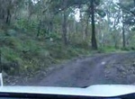
Ride through Cambanoora Gorge, Queensland, Australia
The Cambanoora Gorge runs between the source of the Condamine River and the town of Killarney in Queensland, Australia. It is also known as the Condamine Gorge or the 14 River Crossings. The gorge begins in the historical area of The Head which is borderd by Wilsons Peak to the east and Mount Superbus to the north. Commencing at this broad grassland, the Gorge narrows... -
Drive or Mountain Bike Camino de Dos Republicas, Organ Pipe Cactus National Monument, Arizona
Camino de Dos Republicas to Gachado line-shack and Dos Lomitas ranch house goes for 10 miles off of Hwy 85. This road is rough and crosses several washes. Please read the caution signs at the beginning of this road. The Gachado Line Camp main house is a great example of vernacular architecture, which means that the house was entirely built using materials found natur... -
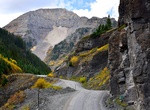
Off-road Camp Bird Road, Ouray, Colorado
Camp Bird Road (Co Rd 361) is a 4.4 mile mountain road southwest of Ouray County, in Colorado. The road is accessible from June until October. -
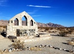
Off-road to Camp Iron Mountain Chapel, California
Camp Iron Mountain was a World War II installation, one of a number established during the 1942- 44 period. It was located in the Desert Training Center/California Arizona Maneuver Area, just north of Camp Granite, almost halfway between Indio and the Colorado River, south of Needles. Camp Iron Mountain was primarily used by the 3d Armored Division. Camp Iron Mountai... -
Off-road to Camp Reno, Arizona
Camp Reno was established by the 1st Cavalry in 1867 and abandoned in 1870. It was an outpost of Fort McDowell and was intended to establish a military presence in Tonto Basin and surrounding areas due to the problems settlers and ranchers were having with regular raids by the Apaches. Not much is left of Camp Reno, the desert has reclaimed the site except for a few ... -
Off-road Canebrake Road/Chimney Creek Road, Inyokern, California
Chimney Peak Recreation Area includes most of the Bakersfield Field Office's Southern Sierra Recreation sites and Wilderness areas, including Domelands Wilderness, Sacatar Trail Wilderness, Owens Peak Wilderness, Chimney Peak Wilderness, Long Valley Campground, Chimney Creek Campground, Walker Pass Campground, the Owens Peak segment of the Pacific Crest National Sceni... -
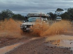
Off-road Canning Stock Route, Western Australia
The Canning Stock Route is a track that runs from Halls Creek in the Kimberley region of Western Australia to Wiluna in the mid-west region. With a total distance of around 1,850 km (1,150 mi) it is the longest historic stock route in the world. The Canning Stock route is considered one of the world's great four-wheel drive adventures. Apart from keeping the track ope...

Price: $551.14