Give us feedback!


 See all

Our philosophy is simple. We want to encourage you to dream. BIG! Then we help you plan your trip, get the most out of it while you're traveling and help you share your experience with friends.
Join Now It's FREE
Dream Packages
Duration: 12 hours
Price: $211.46
Price: $211.46
Duration: 14 hours
Price: $551.14
Price: $551.14
Duration: 4 hours
Price: $135.27
Price: $135.27
Duration: 10 hours
Price: $180.27
Price: $180.27
Dreams Still To Do
Checked-Off Dreams
Dreams Still To Do
Checked-Off Dreams
Advertisement
Explore Driving Experiences
-
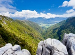
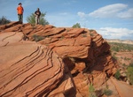
Explore Takaka Hill, New Zealand
Takaka Hill is a range of hills located in the northwest of the South Island of New Zealand. Made of marble which has weathered into many strange forms and with numerous sink holes, it is typical karst country. There is only one road winding over and around the flanks of Takaka Hill, State Highway 60, following the valleys of the Takaka River to the northwest and... -
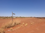
Off-road Talawana Track, Western Australia
The Talawana Track is a remote unsealed track that runs between Windy Corner on the Gary Highway and the Marble Bar Road in Western Australia, a distance of 596 kilometres. The majority of it was built by Len Beadell and the Gunbarrel Road Construction Party in 1963 as part of a series of connecting roads for the Woomera rocket range in South Australia. It was the fin... -
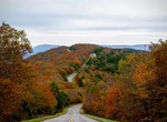
Drive Talimena National Scenic Byway, Arkansas & Oklahoma
Built to capitalize on amazing views, the Talimena runs through south east Oklahoma, into Arkansas, taking a 54 mile high road through a Ouachita national forest. The Talimena Scenic Drive is a National Scenic Byway in southeastern Oklahoma and extreme western Arkansas spanning a 54.0-mile (86.9 km) stretch of Oklahoma State Highway 1 (SH-1) and Arkansas Highway 88 (A... -
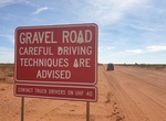
Drive Tanami Road (McGuire Track), Western Australia & Northern Territory
The Tanami Road, also known as the Tanami Track, Tanami Highway, and the McGuire Track, is a road in Australia that runs between the Stuart Highway in the Northern Territory and the Great Northern Highway in Western Australia. It is also known as State Route 5 in the Northern Territory. Its southern junction is 19 kilometres (12 mi) north of Alice Springs and the nort... -
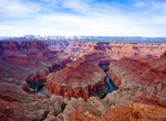
Off-road to Tatahatso Point, Arizona
Tatahatso Point overlooks Point Hansbrough and the Colorado River in north-central Arizona. Hiking Permit from office Lake Powell Navajo Tribal Park -
Off-road or Mountain Bike Taylor Canyon Road (White Rim Road), Canyonlands National Park, Utah
Taylor Canyon Road is accessed from White Rim Road (permit required) in Canyonlands National Park. -
Off-road Tectonic Gorge, Ocotillo Wells SVRA, California
Tectonic Gorge is a huge canyon in the northeastern section of Ocotillo Wells Recreation Area. The canyon and its accompanying badlands is one of the “sickest” terrains in Ocotillo Wells. Not only is this a popular place for riding, it was also the location for the series finale of The X-Files. -
Off-road Temple Bar Back Road, Arizona
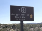
The Temple Bar Back Road is a 25.60mile gravel road that connects Temple Bar with Gregg’s Hideout Road. The drive takes you past old mines and offers views of Lake Mead. Access: Take Bluebird Canyon down to Hualapai Wash, backtrack to Gregg’s Hideout Road. Watch for a sign at the Temple Bar turnoff. Follow the dirt road to Temple Bar. From Temple Bar... -
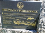
Off-road & Hike to Temple Fork Saw Mill, Utah
This hike is a fairly easy and popular. The first half of this trail is not shaded so be sure to bring lots of water. A large portion of the trail goes along the river and its fun to see all the beaver dams and felled trees. Temple Fork Saw Mill burned down so all you will see at the end is a little monument (no buildings). -
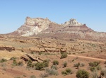
Off-road Temple Mountain Road, San Rafael Swell, Utah
Temple Mountain Road climbs along canyons and buttes to the Swell’s highest point, Temple Mountain, at 6,798 feet. There are many rugged roads left by former uranium mining operations to explore. Also Temple Mountain itself is a popular but technical day climb. 4WD or AWD recommended or park and hop on mountain bike and pedal the 10-mile loop around the mountai... -
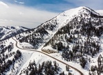
Drive Teton Pass, Wyoming
Teton Pass is a high mountain pass in the western United States, located at the southern end of the Teton Range in western Wyoming, between the towns of Wilson, Wyoming and Victor, Idaho. The pass provides access from the Jackson Hole valley in Wyoming to the Teton Valley of eastern Idaho, including the access route to Grand Targhee Resort through Driggs, Idaho. To th... -
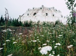
Visit The Abandoned Igloo City Hotel, Denali National Park and Preserve
In Cantwell, Alaska along the George Parks Highway, this abandoned four-story igloo-shaped hotel has become a roadside attraction. Originally constructed in the 1970's, the hotel never opened, reportedly due to building code violations. A string of owners have used the site as a gas station and gift shop. -
Off-road to The Barracks Trail, Utah
The Barracks Trail is 27 miles that goes through the gorgeous landscape of Southern Utah. The Barracks is a great canyon along the East Virgin River just outside Zion National Park. -
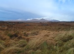
Drive or Cycle The Bog Road (Roundstone Bog), Connemara, Ireland
Driving or Cycling The Bog Road through Roundstone Bog in Connemara, County Galway offers tranquil scenery with the backdrop of the Twelve Bens. Take the R341 towards Ballyconneely, turn left at Ballinaboy before the bridge and you will discover the famous Roundstone Bog conservation area. -
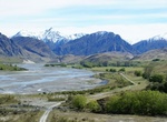
Off-road The Branches Road, New Zealand
The Branches Road is a beautiful remote 4WD road located at the end of Skippers Canyon Road that leads to Branches Station. The road is more exposed and the cliff is getting higher than on the first part on Skippers Road. In winter months the road is not recommended due to mud, frost and snow.
Price: $335.27