Give us feedback!


 See all

Our philosophy is simple. We want to encourage you to dream. BIG! Then we help you plan your trip, get the most out of it while you're traveling and help you share your experience with friends.
Join Now It's FREE
Dream Packages
Duration: 10 hours
Price: $180.27
Price: $180.27
Duration: 3 hours
Price: $120.56
Price: $120.56
Duration: 6 hours
Price: $499.00
Price: $499.00
Duration: 3 days
Price: $559.53
Price: $559.53
Dreams Still To Do
Checked-Off Dreams
Dreams Still To Do
Checked-Off Dreams
Advertisement
Explore Driving Experiences
-
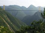
Drive or Walk Shiziguan Floating Bridge, Xuan'en County, China
Shiziguan Floating Bridge is a wooden plank bridge that runs through the Shiziguan scenic area in China. The bridge spans the Qingjiang river and is 1,640 feet (500 metres) long and 4.5 meters wide. The bridge opened to the public on 1st May 2016. -
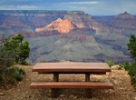
Drive to Shoshone Point, Grand Canyon National Park, Arizona
A 1 mile unimproved dirt road leads to Shoshone Point, an area with spectacular views of Grand Canyon. The site features a covered pavilion, picnic tables, grills, trash cans and a vault toilet. There is no water or electricity at the site. The National Park Service offers this site on the South Rim of Grand Canyon for reservation by groups wishing to host a wedd... -
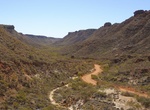
Drive Shothole Canyon, Cape Range National Park, Western Australia
An unsealed road traverses the bottom of this scenic canyon in one of the most rugged areas of Cape Range National Park. The 12km scenic drive along the floor of this spectacular gorge takes you deep inside Shothole Canyon. From the carpark take a short walk (Class 4) up the steps to a lookout with views of the rugged limestone walls leading back to Exmouth Gulf. Th... -
Drive across Sidu River Bridge, China
The Sidu River Bridge (Siduhe Bridge) is a 1,222 m-long (4,009 ft) suspension bridge crossing the valley of the Sidu River near Yesanguan in Badong County of the Hubei Province of the People's Republic of China. It opened to traffic on November 15, 2009. The bridge spans a 500 m (1,600 ft) deep valley of the Sidu River (a left tributary of the Qingjiang River), and ha... -
Drive Sierra Vista Scenic Byway, Sierra National Forest, California
The Sierra Vista Scenic Byway is an 82.7-mile (133.1 km) route through the Sierra National Forest in the U.S. state of California. Many examples of the Sierra’s most distinctive granite domes, meadows and glacial valleys can be seen along the way. The Sierra Vista Scenic Byway begins two miles (3 km) north of the foothill community of North Fork, climbing the we... -
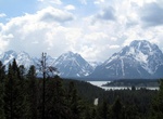
Drive or Bike to Signal Mountain Viewpoint, Grand Teton National Park, Wyoming
Signal Mountain is an isolated summit standing 7,720 feet (2,350 m) above sea level. The mountain is located in Grand Teton National Park in the U.S. state of Wyoming. Signal Mountain has a 5-mile (8.0 km) long road providing vehicular access to an observation area located just below the main summit. The Signal Mountain Trail is a hiking trail that goes from Signal Mo... -
Drive Silverado Trail, Napa Valley, California
The Silverado Trail is a scenic route that travels 29 miles along the Eastern edge of the Napa Valley, parallel to and several miles to the east of California State Route 29. The road began as a trail built in 1852 after flooding made the main Napa Valley road impassable. Later, it served as a wagon trail to link cinnabar mines on Mount St. Helena to San Pablo Bay, th... -
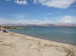
Off-road or Hike to Sinker Reef Beach, Two Peoples Bay Nature Reserve, Albany, Western Australia
Those with four-wheel drive vehicles can also set out on Sinker Reef Track to Sinker Reef Beach and enjoy magnificent coastal views. This portion of Two Peoples Bay National Park is much more rugged than the northern side of the park. Jagged black rocks rise in rows along this entire stretch of coastline and the track to get there is about 2km in length and can be tra... -
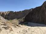
Off-road or Hike Sin Nombre Canyon, Anza-Borrego Desert State Park, California
Canyon Sin Nombre Rd is a 4.2 mile trail through southern part of Anza-Borrego Desert State Parkto Carrizo Creek Wash. -
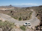
Drive Sitgreaves Pass, Arizona
Sitgreaves Pass is along the old Route 66 and tops out at 3,550 feet. The pass was named for Captain Lorenzo Sitgreaves, who traveled through the area in 1851. It's a very narrow, two-lane blacktop with no shoulders, crazy switchbacks and steep drop-offs plunging thousands of feet down. There are memorials to deceased people whose cremains are scattered at the site. ... -
Camp at Six Mile Cove, Lake Mohave, Nevada
For an off-the-beaten-path experience, camp at Six Mile Cove! Located on Lake Mohave, Six Mile Cove is about 3 miles (via lake) south of Cottonwood Cove. How to Get There: The cove can be accessed by a dirt road from Cottonwood Cove Road. Turn off Hwy 95 onto Cottonwood Cove Road for 6.8 miles. Turn right onto Mead Davis Powerline Rd. Drive down this dirt road for aro... -
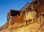
Off-road to Skidoo, California
Skidoo lies at an elevation of 5689 feet (1734 m) and is a virtual ghost town located in Death Valley National Park. It is on the National Register of Historic Places. Skidoo ghost town has over 1000 mines. Skidoo was famous in the first decade of the 20th century when gold had been found in the area. Within a decade the town had been abandoned, however, and now no st... -
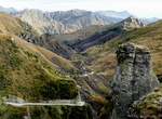
Off-road Skippers Canyon, New Zealand
Skippers Canyon is a historic and scenic gorge, some 22 kilometres in length, that is located several kilometres north of Queenstown. Today accessed from Queenstown via the same road that leads to Coronet Peak skifield, Skippers Canyon houses the Shotover River, one of New Zealand's richest gold bearing rivers which was named by William Gilbert Rees. Rees, his wife Fr... -
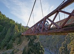
Cross or Jump Off Skippers Canyon Bridge, New Zealand
Skippers Canyon is a historic and scenic gorge, some 22 kilometres in length, that is located several kilometres north of Queenstown. Skippers Canyon houses the Shotover River, one of New Zealand's richest gold bearing rivers which was named by William Gilbert Rees. The first bridge that enabled the gold miners to safely reach Skippers Point was a suspension stru... -
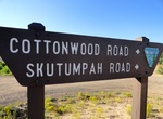
Off-road Skutumpah Road (BLM 500), Grand Staircase-Escalante National Monument, Utah
Skutumpah Road, also known as BLM 500, is a scenic route through the Grand Staircase-Escalante National Monument in Utah. It's a primitive road requiring high-clearance and 4WD vehicles for most of its length. The road offers access to various natural features and hiking trails within the monument, showcasing its unique geology and remote beauty.

Price: $1457.59