Give us feedback!


 See all

Our philosophy is simple. We want to encourage you to dream. BIG! Then we help you plan your trip, get the most out of it while you're traveling and help you share your experience with friends.
Join Now It's FREE
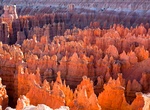
Dream Packages
Duration: 3 hours
Price: $120.56
Price: $120.56
Duration: 10 hours
Price: $199.57
Price: $199.57
Duration: 8 hours
Price: $108.64
Price: $108.64
Duration: 3 days
Price: $604.38
Price: $604.38
Dreams Still To Do
Checked-Off Dreams
Dreams Still To Do
Checked-Off Dreams
Advertisement
Explore Driving Experiences
-
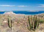
Off-road San Evaristo Inland Road (Mission Trail), Baja California Sur, Mexico
Just south of San Evaristo is a 4WD road that goes inland up the mountains and eventually gets to Hwy 1 via a few different routes. This road goes by some old mission ruins. The road is initially steep and eroded as it heads up into the mountains — but should be no problem for a high clearance 4x4. Once you get to the top there are great views of the Sea of Cor... -
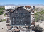
Off-road to San Gregorio Historical Marker, Borrego Springs, California
San Gregorio Historical Marker (#673) is to mark the location of the Anza Expeditions of 1774 and 1775 made their camps. Water for the 240 people and over 800 head of stock on the 1775 march was obtained from a series of wells. Located east of Borrego Springs, California. -
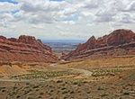
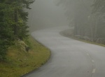
Drive through San Rafael Swell & Spotted Wolf Canyon, Utah
Interstate 70 (I-70) is a mainline route of the Interstate Highway System in the United States connecting Utah and Maryland. In Utah between Fremont Junction and the junction of SR-24 near Green River, Interstate 70 crosses a geologic feature called the San Rafael Swell. The construction of the freeway through the swell is listed as one of the engineering marvels of t... -
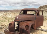
Off-road to San Rafael Swell Studebaker Truck, Utah
Abandoned Studebaker Truck in San Rafael Swell. -
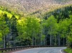
Drive Santa Fe National Forest Scenic Byway, New Mexico
Santa Fe National Forest Scenic Byway originates in downtown Santa Fe at the oldest public building in America – the Palace of the Governors – and loops 15 miles through an aspen-evergreen forest to the Santa Fe Ski Basin. The Santa Fe National Forest covers 1.6 million acres of mountains, valleys and mesas ranging from 5,000 to 13,000 feet in elevation. ... -
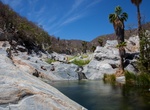
Off-road to Santa Rita Hot Springs, Baja California Sur, Mexico
Explore some of Baja’s natural wonders that lie off the beaten path by off-roading to the breathtaking freshwater pools and hot springs of Santa Rita. It can be reached by a dusty desert roads past the small villages of Santiago and San Jorge, located 90 minutes north of Los Cabos on the East Cape side of the peninsula. To access Santa Rita’s secluded cany... -
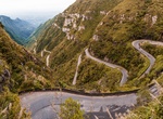
Drive SC-390 in Serra do Rio do Rastro, Brazil
Serra do Rio do Rastro (Mountain Range of the River of the Track) is a mountain range located in the southeast of the state of Santa Catarina, Southern Brazil. It is crossed by the road SC-390, with remarkable landscapes and deep cliffs. This mountain range is situated between the municipalities of Lauro Müller and Bom Jardim da Serra, and its highest point is si... -
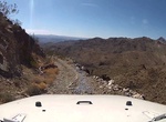
Off-road to Scanlon Bay (Scanlon Ferry Road), Nevada
If you’re looking for one of the most challenging and grueling drives in the country, then Scanlon Ferry Road is for you. The gravel road to Scanlon Bay starts in Gold Butte National Monument and is located on the Nevada side of Lake Mead, across from South Cove. This road is remote, narrow and cliff-exposed, so make sure you and your vehicle are up to the chall... -
Drive Scenic Byway 12, Utah
State Route 12 or Scenic Byway 12 (SR-12), also known as"Highway 12 — A Journey Through Time Scenic Byway", is a state highway designated an All-American Road located in Garfield County and Wayne County, Utah, USA. Proceeding west to east for 122 miles (nearly 200 km), the highway starts south of Panguitch at an intersection with US-89, crosses part of Dixi... -
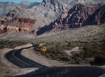
Drive or Bike Scenic Loop Drive, Red Rock Canyon, Nevada
The 13 mile Scenic Drive through Red Rock Canyon allows visitors to explore the highs and lows of the canyon from their vehicle or bicycle, with many scenic stops and and trailheads along the way. Entrance fees support visitor facilities and upkeep for this world-renowned scenic drive. Bicycles are allowed on the one-way Scenic Drive, paved spur roads, and designated... -
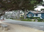
Drive Scenic Road, Carmel-By-The-Sea, California
Scenic Road goes along Carmel Beach in Carmel-By-The-Sea, California. -
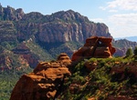
Off-road or Mountain Bike Schnebly Hill Road, Sedona, Arizona
Schnebly Hill Road is a scenic 13 mile route the goes eastward out of Sedona to intersect Interstate 17. Begin the drive off Interstate 17 where it start dropping from the top of massive Mogollon Rim more than 2,000 feet into the town of Sedona. Mountain bikers looking for an easy day will enjoy the ride down. This is a rough 4WD only road. If you stop along the rou... -
Drive Schoodic Loop Road, Acadia National Park, Maine
Schoodic Loop Road is a one-way 7-mile (11 km) long loop road through Schoodic Peninsula in Acadia National Park, Maine. The main feature is Schoodic Head, the highest point on the peninsula at 440 feet (130 m) above sea level. A number of hiking trails ascend the Head. Other features include the picnic area at Frazer Point, views of Schoodic Point, Blueberry Hill, an... -
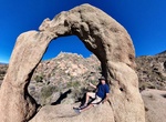
Find Scorpion Arch, Arizona
NOTE: Location is only for Arrastra Mountain Wilderness, not the actual arch. Do some research online to find exact location. Scorpion Arch is a freestanding arch located in the middle of nowhere in Arizona's Arrastra Mountain Wilderness between Wickenburg and Kingman in Arizona near the ghost town call Nothing. It’s about half the size of Utah’s Delicate... -
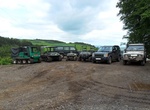
Experience Scottish Off Road Driving Centre, Cupar, Scotland
The Scottish Off Road Driving Centre is a big, challenging 4 x 4 offroad driving course in Scotland. The off-road driving range in Fife has a wide variety of natural and man made obstacles designed to offer challenges for every 4x4 and All Terrain Vehicle user from the complete novice to the hardened professional.
Price: $270.00