Give us feedback!


 See all

Our philosophy is simple. We want to encourage you to dream. BIG! Then we help you plan your trip, get the most out of it while you're traveling and help you share your experience with friends.
Join Now It's FREE
Dream Packages
Duration: 6 hours
Price: $162.00
Price: $162.00
Duration: 12 hours
Price: $211.46
Price: $211.46
Duration: 4 days
Price: $772.57
Price: $772.57
Duration: 3 days
Price: $604.38
Price: $604.38
Dreams Still To Do
Checked-Off Dreams
Dreams Still To Do
Checked-Off Dreams
Advertisement
Explore Driving Experiences
-
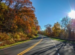
Drive Skyline Drive, Shenandoah National Park, Virginia
Skyline Drive runs 105 miles north and south along the crest of the Blue Ridge Mountains in Shenandoah National Park and is the only public road through the park. It takes about three hours to travel the entire length of the park on a clear day. You can enter Shenandoah at only four places: Front Royal Entrance Station near Rt. 66 and 340 Thornton Gap Entrance Sta... -
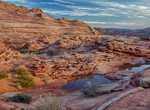
Hike to Sky Pocket & Lost City, Vermilion Cliffs National Monument, Arizona
Sky Pocket and Lost City are two remote rock formations areas in Vermilion Cliffs National Monument east of White Pocket. Off-road to the "trailhead" and head north following the white cliffs on the left side of the canyon. -
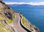
Drive Slea Head Drive, Dingle Peninsula, Ireland
The Slea Head Drive is a circular route that begins and ends in Dingle, Ireland. There are a large number of attractions and stunning views on the western end of the peninsula. The route is clearly labelled by road signs throughout its length. Expect to spend about a half-day to make sure to see everything. The road is very narrow. Take the loop clockwise to go in sam... -
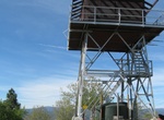
Off-road to Smith Peak Lookout, Stanislaus National Forest, California
Smith Peak Lookout features an exterior wrap-around walkway and is regularly staffed by Forest Service employees. -
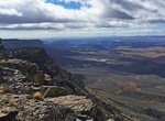
Off-road Smoky Mountain Road (BLM 330), Utah
The Smoky Mountain Road is a designated scenic backway for Utah Route-12 and is a very scenic trail through Grand Staircase Escalante National Monument and Glen Canyon National Recreation Area. But is considered one of the longest, roughest, and most challenging roads in Southern Utah. The 78 miles long dirt road is very rough and links Scenic Byway 12 and Highway 89,... -
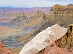
Off-road to Snap Point, Arizona
Snap Point is an awe inspiring viewpoint. It is the official western end of the Grand Canyon north rim. Snap Point provides a tremendous view east back up the Grand Canyon, down to Lake Mead, and north up the Pakoon Basin. On a clear day mountains over 100 miles to the west are visible.Most high clearance 4x4s and pickups can reach the first view near Fort Garrett Poi... -
Off-road Snap Point Road (BLM 1012 & BLM 1680), Grand Canyon-Parashant National Monument, Arizona
Snap Point Road (BLM 1012) is a 19.1-mile point-to-point 4WD trail within the Grand Canyon-Parashant National Monument. The BLM recommends ATVs/UTVs or short-wheelbase, lifted 4x4s. The trail consists of packed dirt and rock which can be rough at times. Snap Point Road is the only way to access Snap Point BLM 1680. BLM 1680 to Snap Point is a 7.2-mile out-and-back tr... -
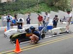
Build and Race a Soap Box Derby Car
The Soap Box Derby is a youth soapbox car racing program which has been run in the United States since 1934. World Championship finals are held each July at Derby Downs in Akron, Ohio. Cars competing in this and related events are unpowered, relying completely upon gravity to move. Using standardized wheels with precision ball bearings, modern gravity-powered racers s... -
Train at Soens Youth Track, Ocotillo Wells SVRA, California
Behind a fenced enclosure and lined with protective hay bales, the Youth Track provides a safe riding area for children to build their skill sets. It is for riders 12 and under on 70cc engines or less. This track is dedicated to Harold Soens, who worked tirelessly to open up the world of OHV to kids. -
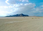
Camp at Soggy Dry Lake, California
Camping is best on one of the sides as the middle can get quite windy at times. Prevailing winds generally come from the west. The lake is a perfect place for large groups to meet and camp with off-road vehicles. -
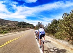
Drive Southern Scenic Route, New Zealand
This journey between Queenstown and Dunedin is approximately 610 kilometres (km) of natural and cultural attractions laid out one after the other – wildlife viewing, short walks, mountain-biking, fishing, hunting, boating, camping, tramping and caving – making it an ideal drive for those with time to explore. The Southern Scenic Route is a tourist highway ... -
Drive South Grade Road (S6), Palomar Mountain, San Diego, California
County Route S6 is a county route in San Diego County, California. It connects Del Mar with Palomar Mountain across San Diego County. It is one of a few San Diego County Routes with a discontinuity in its routing. About four miles (6.4 km) east on SR 76, S6 begins again as South Grade Road, which winds northward on Palomar Mountain. It intersects with S7, then contin... -
Drive South Rim Drive, Gunnison National Park, Colorado
Scenic Drives within the National Park provide a particularly enjoyable experience. The South Rim Drive is 7 miles from Tomichi Point to High Point sporting 12 distinct overlooks. Most are reached by walking a short trail from a turnout. Allow 2-3 hours to allow for viewing from several of the overlooks. Those with limited time should consider stopping at Gunnison Poi... -
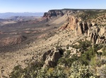
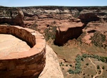
Drive South Rim Drive Hwy, Canyon de Chelly National Monument, Arizona
Check out the views of Canyon de Chelly from the rim, following the South Rim Drive Hwy. Ancient ruins and geologic structures are visible, but in the distance, from turnoffs. -
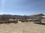
Drive or Ride South Unit Scenic Drive, Theodore Roosevelt National Park, North Dakota
Plan at least 1.5 hours to make it around the South Unit's stunning 36 mile scenic loop drive. The road winds across the rolling, jumbled badlands with fantastic scenery in all directions. Along the way are numerous scenic overlooks and trailheads. The two-way paved loop is open to motor vehicles (including RVs) and cyclists.

Price: $335.27