Give us feedback!


 See all

Our philosophy is simple. We want to encourage you to dream. BIG! Then we help you plan your trip, get the most out of it while you're traveling and help you share your experience with friends.
Join Now It's FREE
Dream Packages
Duration: 3 days
Price: $559.53
Price: $559.53
Duration: 14 hours
Price: $551.14
Price: $551.14
Duration: 4 days
Price: $1457.59
Price: $1457.59
Duration: 2 days
Price: $335.27
Price: $335.27
Dreams Still To Do
Checked-Off Dreams
Dreams Still To Do
Checked-Off Dreams
Advertisement
Explore Driving Experiences
-
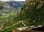
Drive Lysebotn (Lysefjord fjord) Road, Norway
Lysefjord is a fjord located in Forsand in Ryfylke in south-western Norway. Lysebotn, at the far eastern end, is largely populated by workers at the nearby hydroelectric plants at Lyse and Tjodan, both built inside the mountains. A spectacular road which rises almost 900 m (2700 feet) through a series of 27 hairpin bends links Lysebotn with the outside world. -
Drive across Mackinac Bridge, Michigan
The Mackinac Bridge is a suspension bridge spanning the Straits of Mackinac to connect the non-contiguous Upper and Lower peninsulas of the U.S. state of Michigan. Opened in 1957, the bridge (familiarly known as "Big Mac" and "Mighty Mac") is the third longest in total suspension in the world and the longest suspension bridge between anchorages in the Western hemisphe... -
Drive Magnetic Hill (India)
Magnet Hill is a "Cyclops hill" located near Leh in Ladakh, India. The layout of the area and surrounding slopes create the appearance of a hill. The hill road is actually a downhill road. Objects and cars on the hill road may appear to roll uphill in defiance of gravity when they are, in fact, rolling downhill. The other two such magnetic hills are in Gujarat. One is... -
Drive Maloja Pass, Swiss Alps, Switzerland
Maloja Pass is a high mountain pass in the Swiss Alps in the canton of Graubünden, linking the Engadine with the Val Bregaglia, still in Switzerland and Chiavenna in Italy. It marks the divide between the Danube and Po watersheds. Lägh da Bitabergh is near the pass. The road from Chiavenna to Silvaplana with distances and elevation: 0 km ... -
Drive Manaia Road, Egmont National Park, New Zealand
Manaia Road is one of three entry points to Egmont National Park. The other two being Egmont Road and Pembroke Road. -
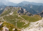
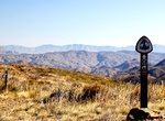
Drive to Mangart Saddle (Mangart Pass), Slovenia
Mangart Saddle or the Mangart Pass (Mangartsko sedloorMangrtsko sedlo) is a mountain saddle in the Julian Alps in northwestern Slovenia. It has an elevation of 2,072 metres (6,798 ft). It is the most common starting point for the ascent of Mt. Mangart (2,679 m or 8,789 ft). The Mangart Road (Mangartska cesta) that leads over Mangart Saddle, with its elevation of 2,055... -
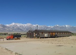
Drive Manzanar Auto Tour, Manzanar National Historic Site, California
Drive the 3.2 mile auto tour around Manzanar National Historic Site to see remnants of orchards, eleven recently excavated rock gardens and ponds, building foundations, and the camp cemetery. -
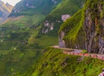
Drive Mã Pí Lèng Pass, Hà Giang province, North Vietnam
The Mã Pí Lèng Pass is a mountain pass on the Highway 4C in the territory of Pai Lung and Pa Vi commune, Hà Giang province, North Vietnam. It is approximately 20 kilometres (12 mi) long, on the section of the Highway 4C connecting the towns of Đồng Văn and Mèo Vạc. It is at the altitude of 1,500 m (4,921 ft). The road was first built... -
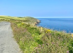
Drive Marine Drive Arch, Isle of Man
Marine Driveruns from Douglas Head to Port Soderick and is home to one of the six viewing points along the Isle of Man's coastline. -
Off-road to Marlboro Point, Moab, Utah
Marlboro Point is a great place to see a sunrise. It's located in a remote area between Canyonlands National Park and Dead Horse Point State Park -
Off-road Martinez Canyon, Tonto National Forest, Arizona
The East Martinez Canyon Road is a 13.1 km trail that connect Box Canyon with Martinez Mine. -
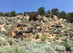
Off-road to Masonic Mining Camp, California
Masonic (formerly Lorena) is a ghost town located about 10 miles (16 km) northeast of Bridgeport, Mono County, California, USA. The town consists of an upper, middle, and lower town; most of the few ruins remaining are in the middle town. Gold was first discovered in the 1860s, but production ceased near the start of the 20th century. The town's population peaked at a... -
Off-road Mason Valley Truck Trail, Julian, California
Mason Valley Truck Trail is a 9.1 mile lightly trafficked point-to-point trail located near Julian, California. -
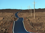
Drive Mauna Kea Summit Road, Big Island, Hawaii
Mauna Kea Summit Road (known as John A. Burns Way) provides access to the Onizuka Center for International Astronomy (at elevation 9,300 ft / 2,835m) then climbs Mauna Kea past the Mauna Kea Ice Age Reserveto the height of 13,780 ft (4,200m) at grades averaging 17% making this the third highest public road in the United States. The road is 14 miles (23 km) long, of wh... -
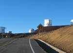
Drive Mauna Loa Observatory Road, Big Island, Hawaii
Mauna Loa Observatory Road is an unmarked 17.1 mile (27.5km) long narrow rough (but paved) road which winds its way towards Mauna Loa Solar Observatory, Mauna Loa Atmospheric Observatory, and AMiBA on the slopes of Mauna Loa. It was connected in 1963 to the old Tom Vance road from 1950.


Price: $103.26