Give us feedback!


 See all

Our philosophy is simple. We want to encourage you to dream. BIG! Then we help you plan your trip, get the most out of it while you're traveling and help you share your experience with friends.
Join Now It's FREE
Dream Packages
Duration: 10 hours 30 minutes
Price: $129.01
Price: $129.01
Duration: 8 hours
Price: $133.44
Price: $133.44
Duration: 4 days
Price: $772.57
Price: $772.57
Duration: 3 days
Price: $559.53
Price: $559.53
Dreams Still To Do
Checked-Off Dreams
Dreams Still To Do
Checked-Off Dreams
Advertisement
Explore Driving Experiences
-
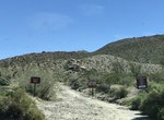
Off-road Little Sahara Recreation Area, Utah
The Little Sahara Recreation Area is a large area of sand dunes, hills and sagebrush flats located in the northeast corner of the Sevier Desert in Juab County in the west central part of Utah, United States. The recreation area is managed by the Bureau of Land Management of the United States Department of the Interior. A 9,000-acre (36 km2) portion of the northwest co... -
Off-road or Hike Lizard Canyon/Wash, Anza-Borrego Desert State Park, California
Lizard Canyon Trail is a moderate 2.8 mile out and back trail located between Julian and Borrego Springs along Route 78. Lizard Wash is usually a good bet for wildflowers just because it’s a wash. At at mile 0.8, the road forks with the main road, Lizard Canyon East Fork, continuing to the left. The rockier road, Lizard Canyon West Fork, heading right. The ... -
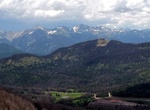
Drive to Lobo Overlook, Colorado
The Lobo Overlook in Colorado sits right on top of the Continental Divide with excellent views of the San Juan Mountains and west toward Pagosa Springs. The lookout has a restroom, picnic tables, a fenced in overlook, and gravel parking lot. From The town of South Fork, travel west on US Highway 160 to the very top of Wolf Creek Pass (about 17 miles) At the top turn... -
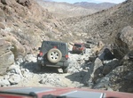
Off-road Lockhart Basin Road, Utah
Lockhart Basin Road is a 59.5 mile point-to-point trail located near Moab just outside the eastern side of Canyonland National Park. It goes through Kane Creek Canyon, Island in the Sky Mesa and Deadhorse Point. Bureau of Land Management (BLM) oversees Lockhart Basin, where no permits are required for you to camp, drive or bike. But the road does include a few techni... -
Drive down Lombard Street, San Francisco, California
Lombard Street is an east–west street in San Francisco, California. It is famous for having a steep, one-block section that consists of eight tight hairpin turns. Lombard Street begins at Presidio Boulevard inside The Presidio and runs east through the Cow Hollow neighborhood. For 12 blocks between Broderick Street and Van Ness Avenue, it is a principal arterial... -
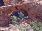
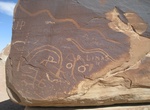
Off-road & Hike to Lone Pine Arch & Petroglyphs, St. George, Utah
Lone Pine Arch (Ripple Arch) is a large natural arch plus unusual rock art panels is located northwest of St. George. The area is know as Red Hollow. The arch is fairly easy to spot, 2/3 the way up the sandstone mountain. It's a considerable hard scrambling to get up under the arch. -
See Lone Tree, Vermilion Cliffs National Monument, Arizona
Lone Tree is located off Paw Hole Road just east of House Rock Road. -
Off-road Lookout Mountain, Inyo National Forest, California
This route starts north of Mammoth Lakes, off of Hwy. 395 at 2S06 and heads north. The road circumnavigates Lookout Mountain with a side trip to the top on road 2S02. There are spectacual 360-degree views of the Long Valley Caldera and other volcanic features such as Obsidian Dome and Mono Craters. -
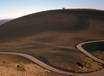
Drive Loop Road, Craters of the Moon National Monument, Idaho
The seven-mile loop road in Craters of the Moon National Monument, Idaho provides unequaled opportunities to explore the National Monument; including access to trails that take you over, under, and around various volcanic features. Trail mileages are round-trip distances. Allow half an hour for the drive itself and more time for stopping at viewpoints and for hiking t... -
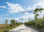
Drive Loop Road Scenic Drive, Ochopee, Florida
Rustic road surrounded by cypress & pine trees, with swamps home to alligators, vultures & turtles. -
Off-road to Los Angeles Mine, Joshua Tree National Park, California
We think this site is called Los Angeles Mine, but do not have any additional information. -
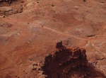
Off-road Lower Cedar Mountain Road Petroglyph Sites, San Rafael Swell, Utah
Lower Cedar Mountain Road is a 9.4 mile trail through San Rafael Swell Recreation Area between Green River and Castle Dale, Utah. There are a group of 4 separate petroglyph sites along this section of the abandoned railroad grade that are all located within close proximity of each other. The sites include Railroad Rock, 45 Degree Rock, the Daisy Chain Panel and the Si... -
Off-road Lower Coyote Canyon, Anza-Borrego Desert State Park, California
Coyote Canyon is located in the northwest area of Anza-Borrego Desert State Park. There is a year-round stream that runs through the canyon and serves as a water source for the bighorn sheep and other wildlife. Coyote Canyon Until the mid 80’s this canyon was drivable all the way from the Terwilliger Valley to Borrego Springs City and back, now the 3.2 miles be... -
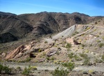
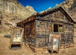
Off-road to Lucky Strike Mine, San Rafael Swell, Utah
Lucky Strike Mine is an old abandoned mining ghost town tucked deep within the southern section of San Rafael Swell, Utah. It's about 23 miles northwest of Temple Mountain and 25 miles south of I-70. December 8, 1949 4 miners were prospecting for uranium and found the coveted yellow ore and staked three claims and named them Lucky Strike 1, 2, and 3. High-clearance ... -
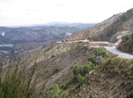
Drive Lyell Highway, Tasmania, Australia
The Lyell Highway (Route A10) is a highway in Tasmania, running from Hobart to Queenstown. It is the one of two transport routes that passes through the West Coast Range, the other being the Anthony Road. The name is derived from Mount Lyell, the mountain peak where copper was found in the late 19th century; the Mount Lyell Mining and Railway Company was the predomina...


Price: $604.38