Give us feedback!


 See all

Our philosophy is simple. We want to encourage you to dream. BIG! Then we help you plan your trip, get the most out of it while you're traveling and help you share your experience with friends.
Join Now It's FREE
Dream Packages
Duration: 3 hours
Price: $312.25
Price: $312.25
Duration: 10 hours
Price: $180.27
Price: $180.27
Duration: 12 hours
Price: $211.46
Price: $211.46
Duration: 3 days
Price: $559.53
Price: $559.53
Dreams Still To Do
Checked-Off Dreams
Dreams Still To Do
Checked-Off Dreams
Advertisement
Explore Driving Experiences
-
Drive Kennedy Developmental Road between Winton and Boulia, Queensland, Australia
Kennedy Developmental Road (State Highway 62) goes between Winton and Boulia. -
Off-road Kessler Peak Road, Mojave Desert, California
Kessler Peak Road starts on Cima Road, 11.7 miles south of Interstate 15. The trail is unmarked, but is approximately a half-mile south of the Teutonia Peak trailhead. There are a few nice primitive campsites along the first few miles of the road. Several abandonded lines and old camps are scattered along the route. The best known mine is the Evening Star Mine, whic... -
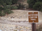
Off-road & Hike Keystone Canyon, Mojave National Preserve, California
Hike the deteriorating road into Keystone Canyon for 3 miles one way, ascending the New York Mountains. Continue cross-country to the top of the ridge for spectacular views. Watch for pinyon pine, juniper, turbinella oak, and even a few white fir near the top. The hike starts 18 miles south of Nipton Road on Ivanpah Road, then 2.5 miles west on an unmarked dirt road. ... -
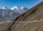
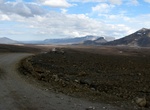
Drive Khargush Pass, Tajikistan
Khargush Pass is a high mountain pass at an elevation of 4.344m (14,251ft) above the sea level, located in eastern Tajikistan. The average gradient is 5.5% though in actuality there are long sections between 10% and 15%. -
Drive through Khyber Pass, Afghanistan & Pakistan
The Khyber Pass (altitude: 1,070 m or 3,510 ft) is a mountain pass connecting Afghanistan and Pakistan, cutting through the northeastern part of the Spin Ghar mountains. An integral part of the ancient Silk Road, it is one of the oldest known passes in the world. Throughout history it has been an important trade route between Central Asia and South Asia and a strategi... -
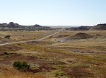
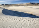
Explore Killpecker Sand Dunes, Wyoming
The Killpecker Sand Dunes Open Play Area Campground is located about 32 miles from Rock Springs. It is a non-fee area and is ADA accessible. It has a vault toilet and fire rings. The Killpecker Sand Dunes Open Play Area is part of the Greater Sand Dunes Area of Critical Environmental Concern (ACEC). ACECs are areas within the public lands where special management atte... -
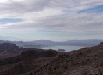
Off-road to Kingman Wash Mine, Arizona
Kingman Wash Mine, Arizona -
Attend King of the Hammers, Johnson Valley, California
King of the Hammers is considered the toughest one-day off-road race in the world. It is the largest off-road race event in North America in terms of both competitors and spectators. It combines desert racing and rock crawling, and has expanded from one race to a series of 5 races held throughout the week that take place each February on BLM-manged public lands in Joh... -
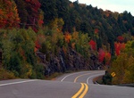
Drive King's Highway 60 (Algonquin Park Corridor), Ontario, Canada
King's Highway 60, commonly referred to as Highway 60, is a provincially maintained highway in the Canadian province of Ontario. The 255.8-kilometre (158.9 mi) highway serves as the primary corridor through Algonquin Provincial Park, where it is dedicated as the Frank McDougall Parkway. East of Algonquin Park, the route serves east–west traffic in the highlands ... -
Drive through Kissing Rock, Bregaglia, Switzerland
The Kissing Rock is a landmark in Bregaglia, Switzerland. -
Off-road or Hike Kjalvegur (Kjolur Trail, Route F35), Iceland
Kjalvegur is a highland road in Iceland, crossing Kjölur north to south. The road begins in the south of Iceland near Haukadalur and behind the Gullfoss waterfall, ending in the north near Blönduós. The road traverses the interior between two glaciers, Langjökull and Hofsjökull. It is the second longest of the roads through the Highlands of ... -
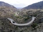
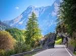
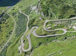
Drive Klausen Pass, Uri, Switzerland
Klausen Pass (German: Klausenpass; elevation: 1,948 metres or 6,391 feet) is a high mountain pass in the Swiss Alps connecting Altdorf in the canton of Uri with Linthal in the canton of Glarus. Somewhat unusually, the boundary between the two cantons does not lie at the summit of the pass, but some 8 kilometres (5.0 mi) down the slope towards Linthal, with the ... -
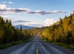
Drive Klondike Highway, Canada & Alaska
The Klondike Highway is a highway that runs from the Alaska Panhandle through the province of British Columbia and the territory of Yukon in Canada, linking the coastal town of Skagway, Alaska, to Dawson City, Yukon. Its route somewhat parallels the route used by prospectors in the 1898 Klondike Gold Rush. In both British Columbia and Yukon, the highway is marked as Y... -
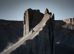
Off-road Knife's Edge, Swing Arm City, Utah
“Knifes Edge” is one of the biggest banked features in Swing Arm City, Utah. This massive feature is seen almost instantly when turning off the main road and into the area. -
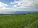
Drive Kohala Mountain Road, Big Island, Hawaii
Kohala Mountain Road, designated Route 250, travels upon the Kohala mountain on the island of Hawaiʻi in the state of Hawaii, United States. Kohala Mountain road, known locally as "the High Road", begins about 1.8 miles (2.9 km) west of Waimea (Hawaii Route 250 southern terminus), near the Hawaii Preparatory Academy campus. Route 19 at this point is known as Hawaii Be...


Price: $199.57