Give us feedback!


 See all

Our philosophy is simple. We want to encourage you to dream. BIG! Then we help you plan your trip, get the most out of it while you're traveling and help you share your experience with friends.
Join Now It's FREE
Dream Packages
Duration: 12 hours
Price: $154.81
Price: $154.81
Duration: 10 hours
Price: $270.00
Price: $270.00
Duration: 9 hours
Price: $229.00
Price: $229.00
Duration: 3 hours
Price: $120.56
Price: $120.56
Dreams Still To Do
Checked-Off Dreams
Dreams Still To Do
Checked-Off Dreams
Advertisement
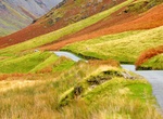
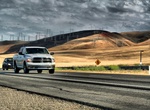
Explore Driving Experiences
-
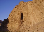
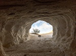
Off-road Hole in the Wall Road, Death Valley National Park, California
The Hole in the Wall Road in Death Valley National Parkgoes through a 400’ deep gap in wall-like ridge. Vehicle needed: High-clearance first four miles to the Hole-in-the-Wall, then 4WD the next two miles to the road’s end due to deep gravel and rocks. Distance: Six miles. Start: Hwy 190, 5.7 miles east of Furnace Creek Inn. Camping: No camping first t... -
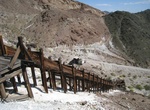
Off-road to Holly Ash Mine, California
The Holy Ash Mine is located on the northeaterns edge of Red Rock Canyon State Park. The Holly Ash Mine was in operation from 1939 to 1958 producing pumice for a variety of uses, but mainly for Holly Cleanser. About 25,000 tons of material were mined. The Holy Ash was a direct competitor of the Dutch Cleanser Mine only a few short miles to the south. -
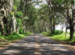
Drive Holo Holo Koloa Scenic Byway, Kauaʻi, Hawaii
Kauaʻi's Holo Holo Koloa Scenic Byway is a state designated scenic byway that runs over 19 miles and connects many of Kauai's most historical and cultural sights such as the Maluhia Road (Tree Tunnel), Puhi (Spouting Horn), The National Tropical Botanical Gardens, and the Salt Beds. -
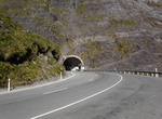
Drive through Homer Tunnel, New Zealand
The Homer Tunnel is a road tunnel in the Fiordland region of the South Island of New Zealand, opened in 1954. New Zealand State Highway 94 passes through the tunnel, linking Milford Sound to Te Anau and Queenstown, by piercing the Main Divide at the Homer Saddle. It connects between the valley of the Eglinton and Hollyford Rivers to the east and that of the Cleddau to... -
Drive Honister Pass, Lake District National Park, England
Honister Pass is a mountain pass in the Lake District in Cumbria, England. It is located on the B5289 road, linking Seatoller, in the valley of Borrowdale, to Gatesgarth at the southern end of Buttermere. The pass reaches an elevation of 1,167 feet (356 m), making it one of the highest in the region, and also one of the steepest, with gradients of up to 1-in-4 (25%). ... -
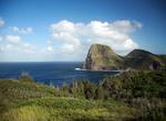
Drive Honoapiilani & Kahekili Highways (Routes 30 & 340),, North Side of West Maui, Hawaii
The Honoapiilani Highway (Route 30) is a road on West Maui, Hawaii. It begins in downtown Wailuku, extending south through Waikapu and Maalaea. Following terrain of the island it circumvents the West side of West Maui connecting Olowalu, Launiupuko, Lahaina, Kahana, through the regions of Kapalua and Honolua, and ending in Honokohau Bay. At this point the road continu... -
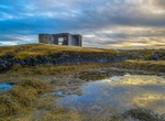
Off-road to Hópsnes, Grindavík, Iceland
A spit next to the town of Grindavík. It was formed during an eruption from a row of craters north of the town (Sundhnúksröðin). Port conditions are good as a result of the lava entering the sea. -
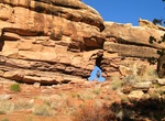
Off-road Horse Canyon Road, Canyonlands National Park, Utah
Offroad Horse Canyon Road to Tower Ruin in Canyonlands National Park. Horse Canyon road leads to several arches and cultural sites. Permit required for day and overnight use. Roads travel along canyon bottoms where deep sand, deep water and quicksand are common. Too sandy for mountain bikes. At Peekaboo, vehicle campsites are available and prehistoric rock art may b... -
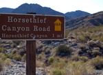
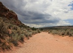
Off-road or Mountain Bike Horse Thief Canyon Road, Arizona
This bumpy but mostly easy ride follows the bed of Horse Thief Wash through Lake Mead NRA backcountry up to the base of Wilson Ridge, where it dead-ends into a sandy and primitive campground and hiker access to Mount Wilson Wilderness Area. The road gets narrow in parts and has several large rocks sticking up in the middle, but a high-clearance vehicle (or good mounta... -
Off-road House Rock Valley Rd (BLM 1065), Utah & Arizona
House Rock Valley Road features a national monument, sweeping vistas, Hikes and a chance of spotting California condors. From the south, House Rock Valley Rd is accesses from Hwy 89A approx. 43 miles east of Fredonia, AZ or 27.5 miles from Navajo Bridge. The roadcontinues north for 29.5 miles to U.S. Route 89 in Utah. The northern entrance is via The Cockscomb Rd vi... -
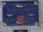
Off-road to HS-4 Black Knights Helicopter Crash Site Memorial, Salt Wells, Nevada
Five Navy men were killed when their SH-3 Sea King helicopter went down near Sand Mountain on a training exercise on March 22, 1978. Visitors have paid their respects by leaving unopened cans of beer at the base of the memorial. The memorial was restored in March 2022 by E Clampus Vitus in cooperation with the Bureau of Land Management and the U.S. Navy. -
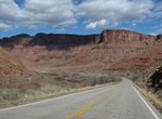
Drive Hwy 128 Scenic Byway, Utah
State Route 128 (SR-128) is a 44.564-mile-long (71.719 km) state highway in the U.S. state of Utah. The entire length of the highway has been designated the Upper Colorado River Scenic Byway, as part of the Utah Scenic Byways program. This road also forms part of the Dinosaur Diamond Prehistoric Highway, a National Scenic Byway. Residents of Moab frequently refer to S... -
Drive I-5 through Central Valley, California
The Central Valley is a broad, elongated, flat valley that dominates the interior of California, United States. It is 40–60 mi (60–100 km) wide and runs approximately 450 mi (720 km) from north-northwest to south-southeast, inland from and parallel to the Pacific coast. It covers approximately 18,000 sq mi (47,000 km2), about 11% of California's land area.... -
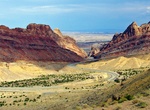
Drive I-70 in San Rafael Swell, Utah
The stretch of I-70 in the San Rafael Swell is a great drive. The harsh elements beat against this dome and eroded it into a wild, broken array of multi-colored sandstone. Wind and water carved this jumble of rock into incredible formations as buttes, canyons, pinnacles and mesas emerged, making the Swell one of the most ruggedly beautiful pockets of terrain in the wo... -
Off-road Ibex Spring Road, Death Valley, California
High-clearance 2.8 miles west from Hwy 127 to signed junction. 4WD west to Ibex Spring and Buckwheat Wash and south to Saratoga Spring Road. Frequent gully crossings, deep washouts, off camber slopes, and/or deep sand make travel slow. Historic mines, verdant springs, remote roads, and towering sand dunes.
Price: $551.14