Give us feedback!


 See all

Our philosophy is simple. We want to encourage you to dream. BIG! Then we help you plan your trip, get the most out of it while you're traveling and help you share your experience with friends.
Join Now It's FREE
Dream Packages
Duration: 4 days
Price: $1457.59
Price: $1457.59
Duration: 14 hours
Price: $551.14
Price: $551.14
Duration: 10 hours 30 minutes
Price: $129.01
Price: $129.01
Duration: 12 hours
Price: $211.46
Price: $211.46
Dreams Still To Do
Checked-Off Dreams
Dreams Still To Do
Checked-Off Dreams
Advertisement
Explore Driving Experiences
-
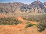
Off-road Jawbone Canyon OHV Area, California
The Jawbone Canyon Off-Highway Vehicle Area provides a wide variety of riding opportunities including cross country play, trail riding, and advanced technical hill climbing opportunities. Jawbone is also a great starting point to begin to explore the hundreds of miles of trail riding opportunities available in the area outside of the OHV Open Area. -
Off-road & Hike to Jawbone Flats, Oregon
NOTE: Jawbone Flats was largely destroyed by the Beachie Creek Fire in 2020. Jawbone Flats is a ghost town in Marion County, Oregon, United States. It is located along Opal Creek, approximately 22 miles (35 km) from Salem, the state capitol, and is accessible via the Opal Pool Loop trail. Established in 1931, Jawbone Flats was a mining camp founded after miners discov... -
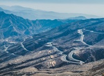
Drive up Jebel Jais, UAE
A 20 km (12 mi) road has been built, which hairpins most of the way up the Jebel Jais mountain on the United Arab Emirates side. Near the top of the road, there are parking places, food providers, toilets and a viewing platform. After a security checkpoint, the road continues up a few kilometers further to the world's longest zip-line and an Etisalat cell tower, as we... -
Drive Jemez Scenic Byway (New Mexico 4)
New Mexico State Road 4 is a state highway in New Mexico, United States of America. It is significant as the main access route connecting the remote town of Los Alamos, Los Alamos National Laboratory, and Bandelier National Monument to other, more major highways in New Mexico. Its total length is approximately 64 miles (103 km). Starting in Los Alamos and then travels... -
Drive John D. Rockefeller Jr. Memorial Parkway, Wyoming
John D. Rockefeller, Jr. Memorial Parkway is a scenic road that connects Grand Teton National Park and Yellowstone National Park in Wyoming, United States. It is federally owned and managed by the National Park Service. It is named in remembrance of John D. Rockefeller, Jr., a conservationist and philanthropist who was instrumental in the creation and enlargement of n... -
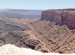
Off-road John's Canyon Road (244), Utah
The route follows an old road which parallels the San Juan river on a large bench several hundred feet above the river and several hundred feet below the top of Cedar Mesa. The John's Canyon Road (244)is located near Mexican Hat, Utah. The road skirts the base of Cedar Mesa between Cedar Point and the Slickhorn Canyon complex. Also goes below Muley Point. -
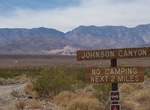
Off-road & Hike Johnson Canyon Road to Hungry Bill's Ranch, Death Valley National Park, California
Johnson Canyon is a fun side trail off West Side Road in Death Valley National Park. High-clearance is recommended for the first 6 miles which is pretty flat, but the last 4 miles require 4WD as it goes up the canyon. Last 0.1 mile of road is over-grown and very wet. Johnson Canyon Rd ends at a steep 2-mile hike leads to Hungry Bill's Ranch, with its rock-walled terra... -
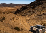
Off-road Johnson Valley OHV Area, Landers, California
Johnson Valley is a varied landscape for the off-highway vehicle driver. It is punctuated by steep red rocky mountains, rolling hills, open valley, dry lake beds and sandy washes. Elevations range from 4,600 feet at Hartwell Hills to 2,300 feet at Melville Dry Lake. Vegetation consists of creosote scrub, annual grasses, wild flowers and Joshua Trees. Johnson Valley of... -
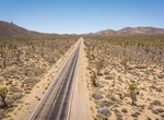
Drive Joshua Tree Highway (Nevada State Route 164), Nevada
Nevada State Route 164 (SR 164) is a state highway in southern Clark County, Nevada. The route, along with the unnumbered Nipton Road located in California, connects U.S. Route 95 (US 95) in Nevada to Interstate 15 in California just south of Primm, via the small town of Nipton, California. The highway is also known as Joshua Tree Highway. The route begins at the Cali... -
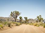
Off-road or Mountain Bike Joshua Tree National Park, California
Mountain bikes and 4-wheel-drive vehicles are welcome in the park. For your own safety and for the protection of natural features, stay on established roads. Tire tracks on the open desert can last for years and will spoil the wilderness experience of future visitors. Off-road vehicles and all-terrain vehicles may not be used in the park. The park’s unpaved... -
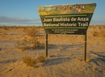
Explore Juan Bautista de Anza National Historic Trail, Arizona & California
The Juan Bautista de Anza National Historic Trail is a 1,210-mile (1,950 km) trail extending from Nogales on the U.S.-Mexico border in Arizona, through the California desert and coastal areas in Southern California and the Central Coast region to San Francisco. The trail commemorates the 1775–1776 land route that Spanish commander Juan Bautista de Anza took from... -
Off-road Jump Canyon (BLM 1033), Grand Canyon-Parashant National Monument, Arizona
Jump Canyon (BLM 1033) is a wide connector trail between Hobble Canyon (BLM 1032) and Hidden Canyon (BLM 1003). The road goes through a beautiful, picturesque, rocky canyon. Hidden Canyon (1003) is a more advanced and technical trail where 4WD and high clearance is required -
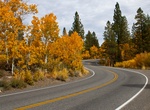
Drive June Lake Loop, California
The majority of June Lake, California is spread narrowly along a five-mile stretch of California State Route 158, which is also known as theJune Lake Loop Road, or in the populated areas,Boulder Drive. Thier are four lakes (June Lake, Gull Lake, Silver Lake & Grant Lake) inside the June Lake Loop. -
Drive Jungo Road (Nevada State Route 49), Nevada
Former State Route 49, also known as Jungo Road, is an unimproved road from County Route 447 (former State Route 34) near Gerlach east to Winnemucca via the ghost towns of Sulphur and Jungo. It crosses the Kamma Mountains northeast of Sulphur. Most of the route runs parallel to the Feather River Route, a rail line originally built by the Western Pacific Railroad. In a... -
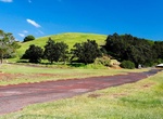
Drive Kahuku Road, Kahuku Unit, Hawaii Volcanoes National Park, Hawaii
Kahuku Road is the main road that goes through the Kahuku Unit in Hawaii Volcanoes National Park. It's a unpaved road beyond Upper Palm Trailhead.


Price: $270.00