Give us feedback!


 See all

Our philosophy is simple. We want to encourage you to dream. BIG! Then we help you plan your trip, get the most out of it while you're traveling and help you share your experience with friends.
Join Now It's FREE
Dream Packages
Duration: 14 hours
Price: $551.14
Price: $551.14
Duration: 4 days
Price: $772.57
Price: $772.57
Duration: 9 hours
Price: $229.00
Price: $229.00
Duration: 12 hours
Price: $211.46
Price: $211.46
Dreams Still To Do
Checked-Off Dreams
Dreams Still To Do
Checked-Off Dreams
Advertisement
Explore Driving Experiences
-
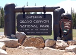
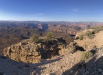
Drive Kaibab Plateau – North Rim Parkway (SR 67), Grand Canyon National Park, Arizona
State Route 67 (SR 67) is a 43.4 mi (69.8 km) long, north–south state highway in northern Arizona. Also called the Kaibab Plateau – North Rim Parkway, SR 67 is the sole road that links U.S. Route 89A (US 89A) at Jacob Lake to the North Rim of Grand Canyon National Park. Along the route, the road heads through the national park as well as Kaibab Nation... -
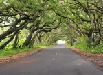
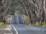
Drive Kalapana-Kapoho Road (Red Road), Big Island, Hawaii
The Kapoho Kalapana Road, also known as the Red Road, is most scenic roads in the state of Hawaii. The 14 miles along the coastline on Highway 137 between mile markers 8 and 22. It runs along the coast through tree tunnels in the lush Puna district, and passes by a few beach parks and hot ponds which make great stops to take in the surroundings. -
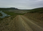
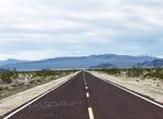
Off-road Kaldidalsvegur (Route 550), Iceland
The Kaldidalsvegur is the shortest of the highland tracks traversing the Highlands of Iceland, therefore the nickname "highlands for beginners". Its name derives from the valley it crosses:kaldidalurmeans "cold dale/valley". Sometimes the Kaldidalsvegur is referred to as simply "the Kaldidalur". The route begins a bit to the north of Þingvellir and to the west o... -
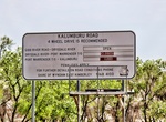
Off-road Kalumburu Road, Western Australia
The Kalumburu Road in the Kimberley region of Western Australia is a 267 kilometre unsealed road that connects the Gibb River Road to the Aboriginal community of Kalumburu on the coast via the Mitchell Plateau. The road, which often becomes inaccessible during the wet season, is suitable for four-wheel drive traffic and facilities are limited to supplies available at ... -
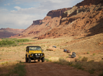
Off-road Kane Creek Canyon Safari Trail, Utah
Kane Creek Canyon Trail is a 26.1 mile out and back trail located near Monticello, Utah. The trail winds back and forth across the floor of Kane Creek Canyon and crosses Kane Creek many times - more than 50 crossings. The lower portion of the canyon is narrow, torturous for 4x4's, but one of the most beautiful. Flash flooding is also possible so watch the weather. L... -
Drive around Kangaroo Island, South Australia
The 420km circular navigation of Kangaroo Island, Australia's third largest island, is on sealed roads and features highlights including Seal Bay and Flinders Chase National Park -
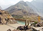
Drive Karakoram Highway (KKH), China & Pakistan
The Karakoram Highway (KKH) is the highest paved international road in the world. It connects China and Pakistan across the Karakoram mountain range, through the Khunjerab Pass, at an elevation of 4,693 metres (15,397 ft) as confirmed by both SRTM and multiple GPS readings. It connects China's Xinjiang region with Pakistan's Gilgit–Baltistan and Khyber Pakhtunkh... -
Drive Katahdin Loop Road, Katahdin Woods and Waters National Monument, Maine
The Katahdin Loop Road is typically open to wheeled vehicle traffic from late May-late October. The Loop Road is accessed via Maine Route 11 and Swift Brook Road. Swift Brook Road is a private logging road and a neighboring timber company manages the two gates on the road leading into the monument. The timber company determines when the gates will open and close for t... -
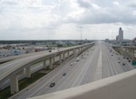
Drive Katy Freeway, Houston, Texas
From the western suburb of Katy to downtown Houston, I-10 is known as the Katy Freeway. This section was widened in 2008 to as many as 26 total lanes, counting the six lanes of the access (frontage/feeder) road, which feature traffic signals, and driveway access and are not limited-access and therefore not technically part of the freeway itself but are ... -
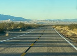
Drive Kelbaker Road, Mojave National Preserve, California
Kelso and Baker are connected by Kelbaker Road, a 56-mile paved road stretching from I-15 at Baker in the north to I-40 east of Ludlow, in the south. About 16 miles southeast of Baker, Kelbaker Road traverses a 25,600-acre area of lava flows and volcanic cinder cones thought to range in age form 10,000 to 7 million years old. In 1973, the area was designated as Cinder... -
Off-road Kelly Grade, Utah
Kelly Grade is the portion of Smoky Mountain Road that abruptly changes elevation by almost one thousand feet from the Kaiparowits Plateau to the flats north of Lake Powell. -
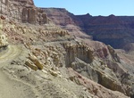
Off-Road to Kelly Point Overlook, Arizona
Kelly Point Overlook is a viewpoint overlooking the Colorado River. The road is through Grand Canyon - Parashant National Monument. The overlook is on NPS land administered by Grand Canyon National Park or Lake Mead National Recreation Area. The road to Kelly Point is long and rough. It is usually a two-day round trip from St. George (115 miles one-way). For Kelly P... -
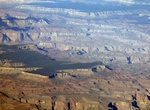
Off-road Kelly Point Road (BLM 1203), Grand Canyon-Parashant National Monument, Arizona
The Kelly Point road (NPS1203) leads to fantastic views but is only for those with the fortitude to withstand hours of bouncing around the cab of a very high clearance 4x4 or a UTV. NPS1203 starts by Mt. Dellenbaugh where Mohave County Road 103 ends at the BLM/NPS boundary. There are numerous flat sandy places to camp at the end of the road near the canyon rim, all wi... -
Drive Kelso Cima Road, Mojave Desert, California
Kelso-Cima Road is a 19 mile paved road and a main highway through the central part of Mojave National Preserve, connecting the "towns" of Kelso and Cima. -
Drive Kennedy Developmental Road between Hughenden to Porcupine Gorge, Queensland, Australia
Porcupine Gorge National Park extends for more than 25 kilometres along Porcupine Creek. The gorge lookout is around 60 kilometres north of Hughenden. The Pyramid campground and gorge walk are another 11 kilometres further north. Zero your tripmeter at the Flinders Discovery Centre and travel north along the Kennedy Development Road (Hann Highway). As you drive along...
Price: $103.26