Give us feedback!


 See all

Our philosophy is simple. We want to encourage you to dream. BIG! Then we help you plan your trip, get the most out of it while you're traveling and help you share your experience with friends.
Join Now It's FREE
Dream Packages
Duration: 10 hours
Price: $270.00
Price: $270.00
Duration: 10 hours 30 minutes
Price: $129.01
Price: $129.01
Duration: 8 hours
Price: $108.64
Price: $108.64
Duration: 10 hours
Price: $199.57
Price: $199.57
Dreams Still To Do
Checked-Off Dreams
Dreams Still To Do
Checked-Off Dreams
Advertisement
Explore Driving Experiences
-
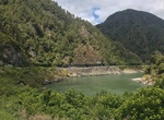
Drive Hawk's Crag (Buller Gorge), New Zealand
Hawk's Crag is a single-lane half tunnel blasted out of a solid rock bluff in the Buller Gorge. It was constructed in 1869. -
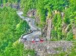
Drive Hawk's Nest Highway, New York
Hawk's Nest is a scenic location outside Port Jervis, New York. Its name is derived from the birds of prey that nest in the area. The location is also known for its winding roads and scenic overlooks in the Delaware River valley. New York State Route 97, which traverses the site, was originally a one-lane dirt road beginning in 1859. It was paved between 1931–19... -
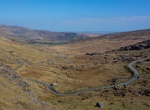
Drive Healy Pass (R574 Road), Ireland
The R574 is an Irish regional road in the Beara peninsula which crosses the Caha Mountains via the (Tim) Healy Pass. It runs from the R572 at Adrigole in County Cork to the R571 near Lauragh in County Kerry. It is a popular tourist route with the pass at an altitude of 300m giving panoramas towards Bantry Bay to the south-east and the Kenmare River to the north-west. ... -
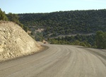
Off-road Hell's Backbone Road, Utah
Hell's Backbone Road (153) is a 38-mile (61 km) gravel road that was built by the Civilian Conservation Corps in the 1930s, and connects the towns of Boulder, Utah and Escalante, Utah. Halfway along the road is Hell's Backbone Bridge, which is 109 feet (33 m) long, and 14 feet (4.3 m) wide. A 1,500-foot (460 m) drop is on either side. Near the bridge are spectacular v... -
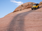
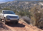
Off-road Hells Revenge Safari Trail, Moab, Utah
Hells Revenge 4x4 Trail is as beautiful as it is challenging. High vantage point offers great views of the La Sal Mountains, Negro Bill Canyon, Abyss Canyon and the Colorado River. Trail is well marked with black tire marks, yellow flame symbols and brown sign posts, but it is still confusing in spots even with a tracklog. Rated a 6 by the Red-Rock Four-Wheelers, the... -
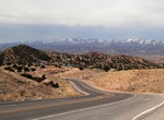
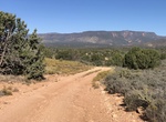
Drive High Road to Taos, New Mexico
The 56-mile (90 km) High Road to Taos is a scenic, winding road through the Sangre de Cristo Mountains between Santa Fe and Taos. (The "Low Road" runs through the valleys along the Rio Grande). It winds through high desert, mountains, forests, small farms, and tiny Spanish Land Grant villages and Pueblo Indian villages. Scattered along the way are the galleries and st... -
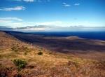
Drive to Hilina Pali Lookout via Hilina Pali Road, Volcanoes National Park, Hawaii
Note: Hilina Pali Road past Kulanaokuaiki Is closed to vehicles (it is open to pedestrians and non-motorized bicycles). The drive to Hilina Pali Overlook is 9 miles (14.5 km) along the Hilina Pali Road (turn off from Chain of Craters Road). Hilina Pali Overlook is approximately 2,282 ft (695.6 m) in elevation and over 12 miles (19.3 km) long. The last lava flow in thi... -
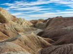
Off-road Hills of the Moon Wash, Anza-Borrego Desert State Park, California
Hills of the Moon Wash is in the Badlands in Anza-Borrego Desert State Park. Access it from Hwy 78 via the Borrego Mounatin Wash Rd (5.5 miles) and cross the San Felipe Wash. The road up this wash starts out fairly easy but gets more difficult as it becomes more narrow and twisty. The wash is 3 miles one way. A high-clearance vehicle is definitely required and 4WD ... -
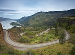
Drive Historic Columbia River Highway, Oregon
The Historic Columbia River Highway is an approximately 75-mile (120 km) scenic highway in the U.S. state of Oregon between Troutdale and The Dalles, built through the Columbia River Gorge between 1913 and 1922. As the first planned scenic roadway in the United States, it has been recognized in numerous ways, including a listing on the National Register of Historic Pl... -
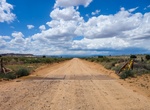
Off-road Hobble Canyon (BLM 1032), Grand Canyon-Parashant National Monument, Arizona
Hobble Canyon (BLM 1032) is a scenic drive within Grand Canyon-Parashant National Monument. It passes besides long grasses along with many livestock corrals. Be careful of livestock on the road. -
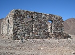
Off-road to Hodges Mine (Hodge Mine), Bradshaw Trail, California
Hodges Mine (Hodge Mine) is located in the Mule Mountains. -
Off-road Hog Canyon OHV, Kanab, Utah
The Hog Canyon OHV Trail System is a network of technical motorized trails north of Kanab, UT offering OHV enthusiasts roughly 30 miles of trails through spectacular terrain ranging from easy sand to extreme rock crawling. The Hog Canyon OHV trails navigate steep inclines, rocky surfaces, narrow passages, and deep sand and are suitable for four-wheel-drive vehicles, A... -
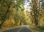
Drive Hoh Valley Drive, Olympic National Park, Washington
The Hoh Rain Forest is located in the stretch of the Pacific Northwest rainforest which once spanned the Pacific coast from southeastern Alaska to the central coast of California. The Hoh is one of the finest remaining examples of temperate rainforest in the United States and is one of the park's most popular destinations. The Hoh lies on the west side of Olympic Nat... -
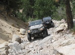
Off-road Holcomb Trail, Big Bear, California
Holcomb View Trail is stop 1 of the Gold Fever Trail near Big Bear Lake. Holcomb Creek (3N93) is very difficult 4WD trail in the Big Bear area. It’s approximately 5.5 miles of rock gardens and off-camber tippy climbs with a few water crossings of Holcomb Creek. -
Off-Road Hole in the Rock Trail (Westside), Utah
The Hole in the Rock Trail (officially the Glen Canyon Recreation Area Road) is a historic road running west of the Escalante River in southern Utah in the western United States. Running almost 200 miles (320 km) from near Escalante to Bluff, it travels within the borders of the Grand Staircase-Escalante National Monument and the adjacent Glen Canyon National Recreati...
Price: $133.44