Give us feedback!


 See all

Our philosophy is simple. We want to encourage you to dream. BIG! Then we help you plan your trip, get the most out of it while you're traveling and help you share your experience with friends.
Join Now It's FREE
Dream Packages
Duration: 4 hours
Price: $135.27
Price: $135.27
Duration: 2 days
Price: $335.27
Price: $335.27
Duration: 3 hours
Price: $312.25
Price: $312.25
Duration: 6 hours
Price: $162.00
Price: $162.00
Dreams Still To Do
Checked-Off Dreams
Dreams Still To Do
Checked-Off Dreams
Advertisement
Explore Driving Experiences
-
Off-road Mormon Trail through East Fork of Lake Canyon (Hole in the Rock Eastside), Utah
Off-road the Mormon Trail (Emigrant Trail) through the East Fork of Lake Canyon, Utah. This is consider the eastern side of the Hole in the Rock Road. From route 276, turn south on Nokai Dome Road and turn right about 5 mles down this dirt road. After around another 3 miles the road turns left and then forks - stay on the same road. The fun part of the trail starts i... -
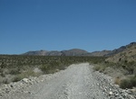
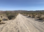
Off-road Mormon Well Road, Nevada
The 41.6 mile Mormon Well Road crosses the Desert National Wildlife Refuge. This well-maintained dirt road that rises in elevation from the desert floor to more than 6,000 feet in elevation. High clearance for some of the rougher places. Did not require 4 wheel drive. Passenger cars commonly seen on the trail. Check here for current road conditions. Mormon Well Spr... -
Off-road Mortero Canyon Road (East), Azna Borrego State Park, California
Mortero Canyon Road eastern trailhead is located off S2 in Azna Borrego State Park. The last part of the road going up the hill is very rough and rocky requires experienced 4WD. -
Off-road Mortero Canyon Road (West), Azna Borrego State Park, California
Mortero Canyon Road (West) connects S2 with the R.R. Water Tower & Phone Booth Dos Cabezas railroad. -
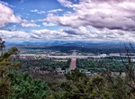
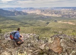
See the View From Mount Ainslie, Canberra
Mount Ainslie is a hill with an elevation of 843 metres (2,766 ft) AHD that is located in the northeastern suburbs of Canberra, in the Australian Capital Territory, Australia. Mount Ainslie lies within part of the Canberra Nature Park. Mount Ainslie borders on the inner suburbs of Campbell, Ainslie and Hackett and is named in honour of James Ainslie, a 19th-ce... -
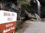
Drive Mountain Waters Scenic Byway, North Carolina
The Mountain Waters Scenic Byway is a two-lane highway in North Carolina, which travels through the Nantahala National Forest in Macon and Swain County, North Carolina counties. The first part of this 61.3-mile (98.7 km) byway follows the combined route of U.S. 64 and NC 28 from Highlands, North Carolina to Franklin, North Carolina and features views of the Cullasaja ... -
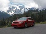
Drive Mount Baker Scenic Byway (Route 542), Washington
State Route 542 (SR 542) is a 57.24-mile-long (92.12 km) state highway in the U.S. state of Washington, serving Mount Baker in Whatcom County. SR 542 travels east as the Mount Baker Highway from an interchange with Interstate 5 (I-5) in Bellingham through the Nooksack River valley to the Mt. Baker Ski Area at Austin Pass. SR 542 begins as Sunset Drive and the Mount Ba... -
Drive Mount Evans Scenic Byway, Idaho Springs, Colorado
The Mount Evans Scenic Byway begins at the junction of Interstate 70 and State Highway 103 near Idaho Springs, Colorado and continues on State Highway 5 through a corridor between the Mount Evans Wilderness where it ends near the summit of Mount Evans. The byway is 28 miles (45 km) in length and gains over 7,000 feet (2,100 m) of elevation. Achieving a final elevation... -
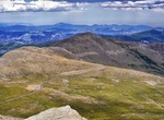
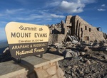
Drive to Mount Evans Summit, Front Range, Colorado
Mount Evans is the highest peak in the namesake Mount Evans Wilderness in the Front Range of the Rocky Mountains of North America. The prominent 14,271-foot (4,350 m) fourteener is located 13.4 miles (21.6 km) southwest by south (bearing 214°) of Idaho Springs in Clear Creek County, Colorado, United States, on the drainage divide between Arapaho National Forest an... -
Off-road Mount Mee Forest Road, Queensland, Australia
Mount Mee is a mountain in Queensland, Australia, located north of the town of Dayboro on the D'Aguilar Range. Offroad on the road connecting Acher campground and The Gantry. The park features six different walking tracks, two picnic grounds, a camping ground, and numerous tracks for offroad driving. Mount Mee State Forest and Forest Reserve is a nature preserve locat... -
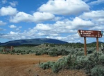
Off-road Mount Trumbull Scenic Loop Drive, Arizona
Start this loop at the Mt Trumbull Schoolhouse at Mohave County Road 5 (CR5 - Southern Section). To get there from Interstate 15, take Exit 2 east onto the Southern Parkway (Hwy 7) toward the airport. Take Exit 3 (River Road) and turn south. Set your vehicle trip odometer to 0 where the pavement ends at the state line. BLM Road 1069: You have now crossed into Ariz... -
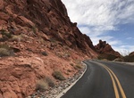
Drive Mouse's Tank Road, Valley of Fire State Park, Nevada
Enjoy a drive through Valley of Fire State Park on Mouse’s Tank Road. Also known as White Domes Road, Mouse’s Tank Road is a paved scenic drive featuring narrow canyons, stunning viewpoints, colorful rocks, petroglyphs and hiking trails. Mouse’s Tank Road forks northward beside the visitor center. This road is only 5.7 miles long, but is one of the m... -
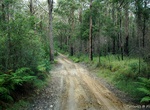
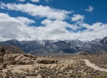
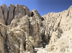
Off-road Movie Flat Road, Alabama Hills, California
The Alabama Hills are a popular filming location for television and movie productions, especially Westerns set in an archetypical "rugged" environment. Since the early 1920s, 150 movies and about a dozen television shows have been filmed here, including Tom Mix films, Hopalong Cassidy films, The Gene Autry Show, The Lone Ranger and Bonanza. Meanwhile Classics such as ... -
Off-road to Mt. Logan Overlook & Hell's Hole, Arizona
Just east of the Sawmill bronze plaque and Mt. Trumbull trailhead along Mohave County Road 5 is the BLM1044 spur road that heads south to Mt. Logan. Reset your odometer to zero at the Fire Danger sign. Look for the grey Kaibab squirrels with their bright white tails in these woods. They were released here from a population taken from the South Rim of the Grand Canyon ... -
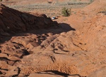
Off-road to Mud Palisades of Olla Wash, Anza-Borrego Desert State Park, California
The Mud Palisades are located at the end of Olla Wash, located near the end of Fish Creek Wash. The deeply eroded cliff faces of the aptly named Mud Palisades of Anza-Borrego Desert State Park in California look like a delicately designed cathedral in the desert. Road condition vary a lot from year to year, but normally any AWD should do.
Price: $604.38