Give us feedback!


 See all

Our philosophy is simple. We want to encourage you to dream. BIG! Then we help you plan your trip, get the most out of it while you're traveling and help you share your experience with friends.
Join Now It's FREE
Dream Packages
Duration: 12 hours
Price: $154.81
Price: $154.81
Duration: 3 days
Price: $559.53
Price: $559.53
Duration: 2 days
Price: $335.27
Price: $335.27
Duration: 12 hours
Price: $103.26
Price: $103.26
Dreams Still To Do
Checked-Off Dreams
Dreams Still To Do
Checked-Off Dreams
Advertisement
Explore Driving Experiences
-
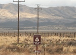
Drive Pony Express Trail Back Country Byway, Utah
Relive a dramatic part of the West's history as you travel the same trail that Pony Express riders covered over 100 years ago. You can stop at stations and modern interpretive sites along the Backcountry Byway where exhausted riders once rested before continuing on to complete their 1,800-mile run. You can extend your visit to the past with a night's stay at the campg... -
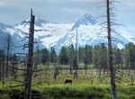
Drive Portage Glacier Highway, Alaska
The Portage Glacier Highway, or Portage Glacier Road, is a highway located in the U.S. state of Alaska. The highway is made up of a series of roads, bridges, and tunnels that connect the Portage Glacier area of the Chugach National Forest and the city of Whittier to the Seward Highway. Most of the highway travels through mainly rural areas just north of the Kenai Peni... -
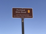
Off-road Portland Mine Road, Arizona
The Portland Mine Road is located off Princess Cove Road north of Katherline Landing. -
Drive Potash-Lower Colorado River Scenic Byway (Potash Road), Moab, Utah
The Potash-Lower Colorado River Scenic Byway (Hwy 279, also known as Potash Road) provides great views of the Colorado River, ancient rock art and dinosaur tracks. It's 17.0 miles (27.4 km) long and takes about an hour. A late afternoon start is rewarding as the sunset on the reddish-orange sandstone cliffs along the route is especially beautiful on the return drive t... -
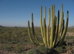
Drive or Mountain Bike Pozo Nuevo Road, Organ Pipe Cactus National Monument, Arizona
Pozo Nuevo Road is a 14 mile road that connects Puerto Blanco Drive with Bates Well Road. Offers views of the Cipriano Hills, the Growler Valley, and the historic Pozo Nuevo line-camp. High clearance or 4x4 recommended. Closed during the winter. Bikes are allowed on all roads open to vehicle traffic. Biking is not allowed on any trails. -
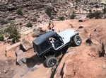
Off-road Pritchett Canyon 4x4 Trail, Utah
Pritchett Canyon is one of the most difficult 4x4 trail you can do in the Moab area. Only extreme 4x4 vehicles should try this trail. Recommend the following 4x4 equipement: 2 Locking Differentials, 33" or Larger Tires, Winch, Oil Spill Containment Material. High possibility of rollover, breakdown annd body damage. There is a small fee to enter Pritchett Canyon. -
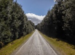
Drive through Pruana Beech Myrtle Forest, Tasmania, Australia
Drive through the Myrtle Forest in the Pruana Forest Reserve. -
Drive or Mountain Bike Puerto Blanco Drive, Organ Pipe Cactus National Monument, Arizona
Puerto Blanco Drive is the other popular road in the park. The 37 mile drive provides access to the Pinkley Peak Picnic Area, Red Tanks trail head, Senita Basin and Quitobaquito Springs. Several stops along the way provide wonderful views and information on the ecology and culture of the Sonoran Desert. The Puerto Blanco Drive was completely reopened in 2014. Be advi... -
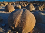
Visit Pumpkin Patch, Ocotillo Wells, California
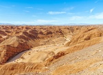
Pumpkin Patch is located within Ocotillo Wells State Vehicular Recreation Area. It can be accessed via the Arroyo Salado Trail, Cut Across Trail or from a few trails from Ocotillo Wells. Pumpkin Patch is a remote field of round rocks is a popular destination in Ocotillo Wells. Created long ago when the climate here was wet, then shaped through years of erosion, the ... -
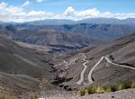
Drive over Andes Purmamarca to the Salina Grande, Argentina
An extremely twisty climb via well-paved road up to the high plateau where you will experience extremely thin air approx 14,000 feet above sea level) and spectacular landscapes of the mountains and the vast salt flat with its interestng natural and man-made geometric patterns. When you get to the small outpost, be sure to spend the Peso or so to use the "Porta-Potty" ... -
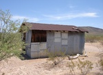
Off-road to Putney Flat Quarry, Ash Fork, Arizona
Abandoned Putney Flat quarry near Ash Fork Arizona about a half mile off of SR89. Located in the Kaibab National Forest. -
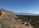
Drive Puyé Scenic Byway, New Mexico
Puyé Scenic Byway is 14miles (22.5km) route out and back that travels through a diverse landscape and exemplifes the natural wonders of New Mexico. It ends at the towering heights of Puye Cliff Dwellings, a National Historic Landmark. -
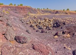
Off-road Quarry Road, Ocotillo Wells SVRA, California
Quarry Road is a well-graded dirt road within the Ocotillo Wells State Vehicular Recreation Area (SVRA) in California. It provides access to various terrains, including the Shell Reef, a unique geological formation with fossilized seashells embedded in stone. The road is also a gateway to other areas like the San Felipe Wash and the Borrego Sink. The road starts o... -
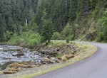
Drive Quartzville Back Country Byway, Oregon
The Quartzville Back Country Byway parallels the winding Quartzville Creek Wild and Scenic River, offering views of old-growth forests and wildlife, and provides easy access to developed and undeveloped picnic and camping sites. The corridor offers a variety of recreational opportunities, such as fishing, camping and boating for skilled whitewater paddlers. Quartzvil... -
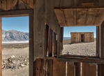
Off-road to Queen of Sheba Mine & Carbonate Mine, Death Valley National Park, California
The Queen of Sheba Mine is found at the end of Queen of Sheba Road in Death Valley National Park, California. Queen of Sheba Road is accessed from the West Side Road. Carbonate Mine workings on hillside northeast of Queen of Sheba Lead Mine. The Queen of Sheba Mine and Carbonate Mine sites serve as historical remnants of the robust mining activities that once thrived...
Price: $604.38